File:Lech de Crespëina Saslonch Cir Chedul Odles Parc Naturel Puez.jpg
Jump to navigation
Jump to search

Size of this preview: 800 × 229 pixels. Other resolutions: 320 × 92 pixels | 640 × 183 pixels | 1,024 × 293 pixels | 1,280 × 367 pixels | 2,560 × 734 pixels | 15,000 × 4,299 pixels.
Original file (15,000 × 4,299 pixels, file size: 50 MB, MIME type: image/jpeg)
Captions
Captions
Add a one-line explanation of what this file represents
Summary[edit]
| Warning | The original file is very high-resolution. It might not load properly or could cause your browser to freeze when opened at full size. |
|---|
| Description |
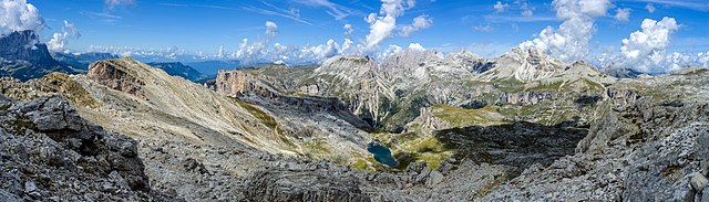
Deutsch: Der Crespëina See mit dem Langkofel, den Cispitzen, das Chedul Tal und der Mont de Sëura Stock links, die Geisler Spitzen und das Puezgebiet in Gröden. Aussicht aus dem Sas Ciampac 2667 m.
English: The Crespëina lake with the Langkofel the Val de Chedul on the left and the Puez mountains on the right. View from Sas Ciampac 2667 m. The Puez-Geisler Nature Park, Dolomites UNESCO World Heritage Site. |
||||||
| Date | |||||||
| Source | Own work | ||||||
| Author |
|
||||||
| Permission (Reusing this file) |
Own work, attribution required (Multi-license with GFDL and Creative Commons CC-BY 2.5). Capture: Photo by Wolfgang Moroder |

| Camera location | | View this and other nearby images on: OpenStreetMap |
|---|

|
NOTE: This image is a panorama consisting of multiple frames that were merged or stitched in software. As a result, this image necessarily underwent some form of digital manipulation. These manipulations may include blending, blurring, cloning, and colour and perspective adjustments. As a result of these adjustments, the image content may be slightly different from reality at the points where multiple images were combined. This manipulation is often required due to lens, perspective, and parallax distortions.
|
Assessment[edit]
|
Licensing[edit]
I, the copyright holder of this work, hereby publish it under the following licenses:

|
Permission is granted to copy, distribute and/or modify this document under the terms of the GNU Free Documentation License, Version 1.2 or any later version published by the Free Software Foundation; with no Invariant Sections, no Front-Cover Texts, and no Back-Cover Texts. A copy of the license is included in the section entitled GNU Free Documentation License. |
This file is licensed under the Creative Commons Attribution-Share Alike 3.0 Unported license.
- You are free:
- to share – to copy, distribute and transmit the work
- to remix – to adapt the work
- Under the following conditions:
- attribution – You must give appropriate credit, provide a link to the license, and indicate if changes were made. You may do so in any reasonable manner, but not in any way that suggests the licensor endorses you or your use.
- share alike – If you remix, transform, or build upon the material, you must distribute your contributions under the same or compatible license as the original.
You may select the license of your choice.
| Annotations | This image is annotated: View the annotations at Commons |

_Gherdeina.jpg)

File history
Click on a date/time to view the file as it appeared at that time.
| Date/Time | Thumbnail | Dimensions | User | Comment | |
|---|---|---|---|---|---|
| current | 08:42, 28 September 2018 | 15,000 × 4,299 (50 MB) | Moroder (talk | contribs) | upper right border | |
| 07:06, 26 September 2018 | 15,000 × 4,299 (45.64 MB) | Moroder (talk | contribs) | cloned | ||
| 11:34, 14 September 2018 | 15,000 × 4,299 (45.51 MB) | Moroder (talk | contribs) | == {{int:filedesc}} == {{LargeImage}} {{Information |Description= {{de|Der Crespëina See mit dem Langkofel, den Cispitzen, das Chedul Tal und der Mont de Sëura Stock links, die Geisler Spitzen und das Puezgebiet in Gröden.}} {{en|The Crespëina lake with the Langkofel the Val de Chedul on the left and the Puez mountains on the right. The Puez-Geisler Nature Park, Dolomites UNESCO World Heritage Site. }} |Source={{Own}} |Author={{User:Morod... |
You cannot overwrite this file.
File usage on Commons
The following 19 pages use this file:
- User:Eatcha/POTY-2018-Round-1-Results
- User:Mai-Sachme/South Tyrol/2018 September 11-20
- User:Mai-Sachme/South Tyrol/2018 September 21-30
- User talk:Moroder/Archives 2018-3
- Commons:Featured picture candidates/File:Lech de Crespëina Saslonch Cir Chedul Odles Parc Naturel Puez.jpg
- Commons:Featured picture candidates/Log/September 2018
- Commons:Featured pictures/Places/Natural/Italy
- Commons:Featured pictures/chronological/2018-B
- Commons:Picture of the Year/2018/Candidates
- Commons:Picture of the Year/2018/R1/Gallery/2018-B
- Commons:Picture of the Year/2018/R1/Gallery/ALL
- Commons:Picture of the Year/2018/R1/Gallery/M09
- Commons:Picture of the Year/2018/R1/Gallery/Panoramic views
- Commons:Picture of the Year/2018/R1/v/Lech de Crespëina Saslonch Cir Chedul Odles Parc Naturel Puez.jpg
- Commons:Quality images/Subject/Places/Natural structures/Panorama/Archive 2018-2019
- Commons:Quality images candidates/Archives September 17 2018
- File:Lech Crespëina Gherdëina.jpg
- File:Lech Crespëina vs Col dala Pieres Gherdëina.jpg
- File:Lech de Crespëina Saslonch Cir Chedul Odles Parc Naturel Puez.jpg
File usage on other wikis
The following other wikis use this file:
- Usage on en.wikipedia.org
- Usage on lld.wikipedia.org