File:Landskap - Ringerike.svg
Jump to navigation
Jump to search

Size of this PNG preview of this SVG file: 568 × 600 pixels. Other resolutions: 227 × 240 pixels | 455 × 480 pixels | 727 × 768 pixels | 970 × 1,024 pixels | 1,940 × 2,048 pixels | 966 × 1,020 pixels.
Original file (SVG file, nominally 966 × 1,020 pixels, file size: 151 KB)
Captions
Captions
Add a one-line explanation of what this file represents
Summary[edit]
| Description |
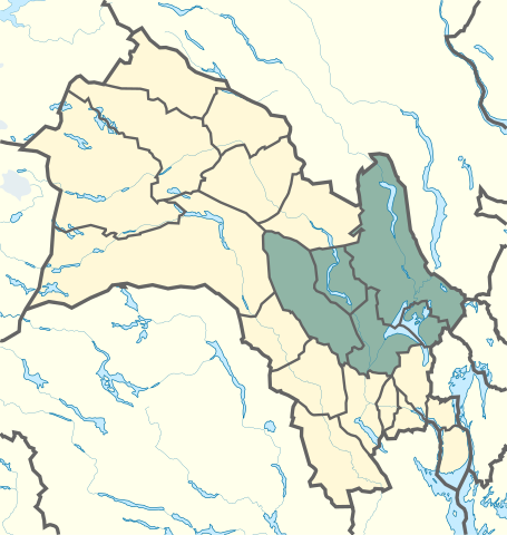
Norsk bokmål: Ringerike er et gammelt navn på bygdene omkring nordre del av Tyrifjorden og lavlandet langs Randselva, Begna (Ådalselva) og Sokna, samt de vidstrakte skogtraktene omkring. I middelalderen omfattet Ringerike også Krødsherad, Modum og Sigdal.[1] |
| Date | |
| Source |
This vector image includes elements that have been taken or adapted from this file: |
| Author |
|
Licensing[edit]
This file is licensed under the Creative Commons Attribution-Share Alike 3.0 Unported license.
- You are free:
- to share – to copy, distribute and transmit the work
- to remix – to adapt the work
- Under the following conditions:
- attribution – You must give appropriate credit, provide a link to the license, and indicate if changes were made. You may do so in any reasonable manner, but not in any way that suggests the licensor endorses you or your use.
- share alike – If you remix, transform, or build upon the material, you must distribute your contributions under the same or compatible license as the original.
- ↑ Store norske leksikon. www.snl.no. Retrieved on 2021-01-15.
File history
Click on a date/time to view the file as it appeared at that time.
| Date/Time | Thumbnail | Dimensions | User | Comment | |
|---|---|---|---|---|---|
| current | 23:34, 14 January 2021 | | 966 × 1,020 (151 KB) | Worldlydev (talk | contribs) | Uploaded a work by *Derivative work: User:Worldlydev *Original work: User:NordNordWest from {{AttribSVG|Norway_Buskerud_location_map.svg|NordNordWest}} with UploadWizard |
You cannot overwrite this file.
File usage on Commons
The following page uses this file:
File usage on other wikis
The following other wikis use this file:
- Usage on no.wikipedia.org