File:Landsat Niijima and Shikinejima Island.jpg
Jump to navigation
Jump to search
No higher resolution available.
Landsat_Niijima_and_Shikinejima_Island.jpg (409 × 541 pixels, file size: 39 KB, MIME type: image/jpeg)
Captions
Captions
Add a one-line explanation of what this file represents
Summary[edit]
| Description |
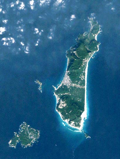
Landsat picture of Niijima (right) and Shikinejima Island (left), Izu islands, Japan. 日本語: 新島式根島衛星写真 |
||
| Date | |||
| Source |
日本語: ランドサットの衛星写真→カシミールにて読み込み→補正
|
||
| Author | っ at Japanese Wikipedia |
Licensing[edit]
| This file is licensed under the Creative Commons Attribution-Share Alike 3.0 Unported license. Subject to disclaimers. | ||
| ||
| This licensing tag was added to this file as part of the GFDL licensing update. |

|
Permission is granted to copy, distribute and/or modify this document under the terms of the GNU Free Documentation License, Version 1.2 or any later version published by the Free Software Foundation; with no Invariant Sections, no Front-Cover Texts, and no Back-Cover Texts. A copy of the license is included in the section entitled GNU Free Documentation License. Subject to disclaimers. |
Original upload log[edit]
| This file was moved from Japanese Wikipedia.
See below for original file information. | ||||||||||||||||||||||||||||||||
| ||||||||||||||||||||||||||||||||
|
| ||||||||||||||||||||||||||||||||
File history
Click on a date/time to view the file as it appeared at that time.
| Date/Time | Thumbnail | Dimensions | User | Comment | |
|---|---|---|---|---|---|
| current | 04:48, 5 July 2006 | | 409 × 541 (39 KB) | Taichi (talk | contribs) | Landsat picture of Shikinejima Island, Izu islands, Japan. '''Source:''' ja:画像:新島式根島衛星写真001.jpg {{Landsat}} Category:Izu Islands |
You cannot overwrite this file.
File usage on Commons
The following 5 pages use this file:
- File:Landsat Shikinejima Island.jpg (file redirect)
- File:新島式根島衛星写真001.jpg (file redirect)
- Category:Niijima
- Category:Niijima, Tokyo
- Category:Shikinejima
File usage on other wikis
The following other wikis use this file:
- Usage on ar.wikipedia.org
- Usage on ast.wikipedia.org
- Usage on az.wikipedia.org
- Usage on ca.wikipedia.org
- Usage on ceb.wikipedia.org
- Usage on ckb.wikipedia.org
- Usage on cs.wikipedia.org
- Usage on de.wikipedia.org
- Usage on en.wikipedia.org
- Usage on en.wikivoyage.org
- Usage on es.wikipedia.org
- Usage on eu.wikipedia.org
- Usage on fa.wikipedia.org
- Usage on frr.wikipedia.org
- Usage on fr.wikipedia.org
- Usage on he.wikipedia.org
- Usage on hy.wikipedia.org
- Usage on it.wikipedia.org
- Discussioni utente:Silvio.dellacqua
- Discussioni utente:Sal73x
- Isole Izu
- Discussioni utente:Flavio Filoni/Archivio 001
- Discussioni utente:Theridel
- Progetto:Geografia/Isole/Inviti e benvenuti
- Discussioni utente:Cittadinovara
- Template:Benvenuto - progetto:Isole
- Discussioni utente:Doge2727
- Discussioni utente:Ramatteo/Archivio1
- Discussioni progetto:Geografia/Isole/Archivio1
- Discussioni utente:Betta27/archivio3
- Discussioni utente:Borgil/Cassetto 2006-2011
- Discussioni utente:Mαρκος/2012/1
- Usage on ja.wikipedia.org
- Usage on ko.wikipedia.org
- Usage on lt.wikipedia.org
- Usage on ml.wikipedia.org
View more global usage of this file.