File:Landsat 29may03 28m Freeport named.jpg
Jump to navigation
Jump to search
Size of this preview: 212 × 597 pixels. Other resolutions: 85 × 240 pixels | 170 × 480 pixels | 272 × 768 pixels | 1,273 × 3,587 pixels.
Original file (1,273 × 3,587 pixels, file size: 838 KB, MIME type: image/jpeg)
Captions
Captions
Add a one-line explanation of what this file represents
Summary[edit]
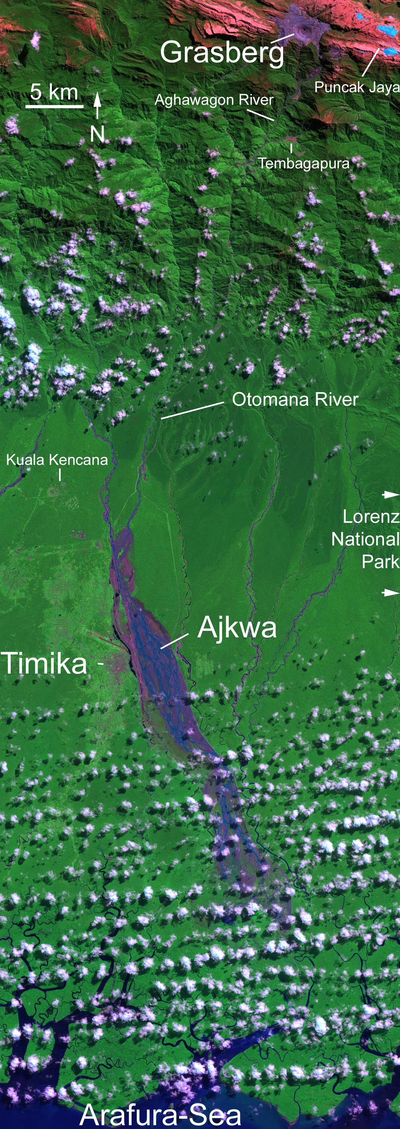
| Description | Grasberg-Mine in West New Guinea (West Papua). Ausschnitt aus dem hochaufgelösten (6000x6000 Pixel) Landsat-Original, beschriftet. Abraum der Mine in violett, hellblau: Gletscher. Falschfarbene Darstellung. Farben: snow and ice appears blue while clouds are white, bare unvegetated land such as the rocky limestone summit ridges appear red or pinkish, the deep purple and grey is the open pit copper mine while the lush rainforest of the lowlands appears green. In the large format image, runoff into the rivers south of the mine shows up in deep purple, much of which is fine debris washed downstream from the mine. |
| Date | |
| Source | http://veimages.gsfc.nasa.gov//16923/landsat_carstenz_29may03_28.5m.jpg |
| Author | Nasa, Landsat 7’s Enhanced Thematic Mapper Plus (ETM+) |
Licensing[edit]
| This file is in the public domain in the United States because it was solely created by NASA. NASA copyright policy states that "NASA material is not protected by copyright unless noted". (See Template:PD-USGov, NASA copyright policy page or JPL Image Use Policy.) | ||
 |
Warnings:
|
File history
Click on a date/time to view the file as it appeared at that time.
| Date/Time | Thumbnail | Dimensions | User | Comment | |
|---|---|---|---|---|---|
| current | 03:36, 8 November 2006 | 1,273 × 3,587 (838 KB) | Echeetah~commonswiki (talk | contribs) | == Beschreibung == {{Information |Description=Grasberg-Mine in West New Guinea (West Papua). Ausschnitt aus dem hochaufgelösten (6000x6000 Pixel) Landsat-Original, beschriftet. Abraum der Mine in violett, hellblau: Gletscher. Falschfarbene Darstellung. F |
You cannot overwrite this file.
File usage on Commons
There are no pages that use this file.
File usage on other wikis
The following other wikis use this file:
- Usage on cs.wikipedia.org
- Usage on de.wikipedia.org
- Usage on en.wikipedia.org
- Usage on es.wikipedia.org
- Usage on fr.wikipedia.org
- Usage on id.wikipedia.org
- Usage on it.wikipedia.org
- Usage on ja.wikipedia.org
- Usage on nl.wikipedia.org