File:La baye françoise.png
Jump to navigation
Jump to search

Size of this preview: 800 × 498 pixels. Other resolutions: 320 × 199 pixels | 640 × 398 pixels | 1,024 × 637 pixels | 1,280 × 796 pixels | 2,560 × 1,593 pixels | 3,409 × 2,121 pixels.
Original file (3,409 × 2,121 pixels, file size: 12.18 MB, MIME type: image/png)
Captions
Captions
Add a one-line explanation of what this file represents
Summary
[edit]
| Author |
Samuel de Champlain |
| Description |
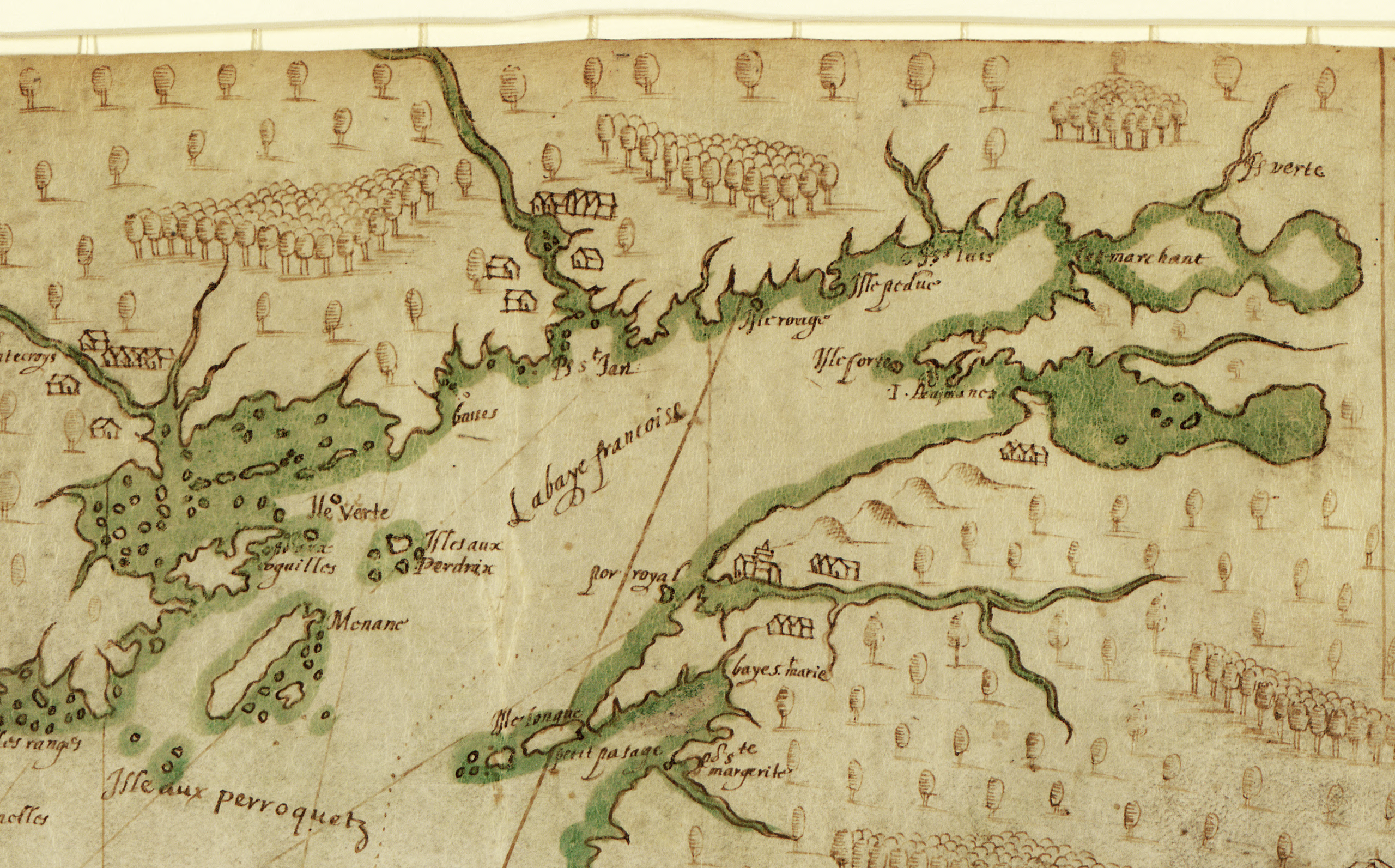
Français : Détail d'une carte sur vélin de style portulan, dessinée par Samuel de Champlain, fondateur de la Nouvelle-France. Il s'agit d'un des grands trésors cartographiques d'Amérique ; la carte offre la première délimitation approfondie de la Nouvelle-Angleterre et des côtes canadiennes. Ce détail montre Port-Royal ; la Baie Françoise (de Fundy), l'île longue. Les noms des lieux et la ligne côtière correspondent de très près au récit de Champlain dans ses Voyages, publiés en 1613. Champlain a personnellement conçu et dessiné la carte. Champlain a fondé ce travail entièrement sur ses propres travaux d'exploration et d'observation, incluant ses entretiens avec des Indiens (sauvages ), ainsi que sur ses propres calculs. La carte montre des habitations le long de la côte, à la fois des établissements français et des villages indiens. Les symboles de colline indiquent des élévations visibles de la côte. Les hauts-fonds dangereux sont indiqués comme des groupes de petits points, et les ancres représentent des endroits où il a jeté l'ancre.
Côte atlantique (Amérique du Nord); Provinces Maritimes; Cartes marines. |
| Date | 1607 |
| Medium |
Русский: Карты
Français : Cartes
English: Maps
中文:地图
Português: Mapas
العربية: خرائط
Español: Mapas |
| Dimensions |
English: 1 manuscript map : color, vellum ; 37 x 55 centimeters |
| Collection |
Русский: Библиотека Конгресса
Français : Bibliothèque du Congrès
English: Library of Congress
中文:国会图书馆
Português: Biblioteca do Congresso
العربية: مكتبة الكونغرس
Español: Biblioteca del Congreso |
| Place of creation |
English: New Brunswick
Français : Nouveau Brunswick
English: New Brunswick
中文:新不伦瑞克
Português: New Brunswick
العربية: New Brunswick
Español: Nuevo Brunswick |
| Notes | Original language title: Description des côtess, pts., rades, illes de la Nouuelle France faict selon son vray méridien |
| References | http://hdl.loc.gov/loc.wdl/dlc.280 |
| Source/Photographer | https://www.loc.gov/resource/g3321p.ct001431/ |
| Other versions | Description of the Coasts, Points, Harbours and Islands of New France WDL280.png |
| Camera location | | View this and other nearby images on: OpenStreetMap |
|---|
Licensing
[edit]
|
This is a faithful photographic reproduction of a two-dimensional, public domain work of art. The work of art itself is in the public domain for the following reason:
The official position taken by the Wikimedia Foundation is that "faithful reproductions of two-dimensional public domain works of art are public domain".
This photographic reproduction is therefore also considered to be in the public domain in the United States. In other jurisdictions, re-use of this content may be restricted; see Reuse of PD-Art photographs for details. | ||||
File history
Click on a date/time to view the file as it appeared at that time.
| Date/Time | Thumbnail | Dimensions | User | Comment | |
|---|---|---|---|---|---|
| current | 23:50, 24 November 2016 | | 3,409 × 2,121 (12.18 MB) | Pierre5018 (talk | contribs) | User created page with UploadWizard |
You cannot overwrite this file.
File usage on Commons
The following page uses this file:
File usage on other wikis
The following other wikis use this file:
- Usage on ceb.wikipedia.org
- Usage on fr.wikipedia.org
- Usage on www.wikidata.org