File:Lüneburg Carte 1730 detail.jpg
Jump to navigation
Jump to search

Size of this preview: 800 × 297 pixels. Other resolutions: 320 × 119 pixels | 640 × 238 pixels | 1,024 × 380 pixels | 1,280 × 475 pixels | 2,824 × 1,049 pixels.
Original file (2,824 × 1,049 pixels, file size: 1.51 MB, MIME type: image/jpeg)
Captions
Captions
Add a one-line explanation of what this file represents
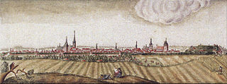
| Description | Stadtansicht Lüneburg, Ausschnitt aus: Carte von Lüneburg, wie sie eigentlich mit Wällen, Mauren und Zwingers nebst andern Wercken fortifizirt ... aufgemessen und cartiret 1730 von C. L. Balsleben, cop. fec. J. Detl. Rechtern (NLA-HSTAH, 32 k Lüneburg, 1 pm) |
| Date | |
| Source | Baudenkmale in Niedersachsen 22.1. Hansestadt Lüneburg, ISBN 978-3-86568-563-6 |
| Author | C. L. Balsleben; J. Detl. Rechtern |
| Permission (Reusing this file) |
Author died more than 70 years ago - public domain |
| Other versions |
 |
|
This work is in the public domain in its country of origin and other countries and areas where the copyright term is the author's life plus 100 years or fewer. | |
| This file has been identified as being free of known restrictions under copyright law, including all related and neighboring rights. | |
File history
Click on a date/time to view the file as it appeared at that time.
| Date/Time | Thumbnail | Dimensions | User | Comment | |
|---|---|---|---|---|---|
| current | 13:47, 30 June 2010 | 2,824 × 1,049 (1.51 MB) | AndreasPraefcke (talk | contribs) | {{Information |Description=Stadtansicht Lüneburg, Ausschnitt aus: ''Carte von Lüneburg, wie sie eigentlich mit Wällen, Mauren und Zwingers nebst andern Wercken fortifizirt ... aufgemessen und cartiret 1730 von C. L. Balsleben, cop. fec. J. Detl. Recht |
You cannot overwrite this file.
File usage on Commons
The following 2 pages use this file: