File:Kuntsevo town (1931).jpg
Jump to navigation
Jump to search

Size of this preview: 800 × 540 pixels. Other resolutions: 320 × 216 pixels | 640 × 432 pixels | 998 × 674 pixels.
Original file (998 × 674 pixels, file size: 412 KB, MIME type: image/jpeg)
Captions
Captions
Add a one-line explanation of what this file represents
 This media file has been nominated for deletion since 2 June 2024. To discuss it, please visit the nomination page.
Do not remove this tag until the deletion nomination is closed. Reason for the nomination: Bogus license tag, no evidence that authors died 70 or more years ago to be PD under COM:Russia.
| |||
| |||
.jpg)
.jpg)
Summary
[edit].jpg&action=edit§ion=1)
| Description |
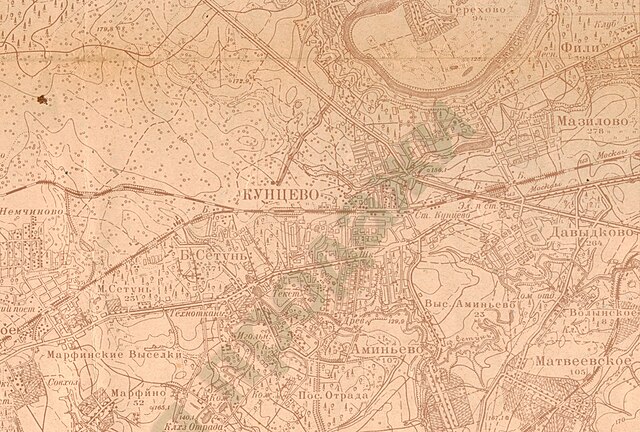
English: A district near Kuntsevo town at the topographic map "Moscow and outskirts" 1931.
Scale 1:50 000
Русский: Район города Кунцево на топографической карта "Москва и окрестности" 1931 года.
Масштаб 1:50 000 Карта составлена в "Госкартогеодезии" при Научно-Исследовательском институте Геодезии и Картографии по материалам топографических съемок Производственного Отдела Г.Г.К. , произведённых в 1922-28 гг., в масштабах 1:25000 и 1:50000 и по материалам съёмок 1926-28 гг. |
| Date | |
| Source | http://susanin.homedns.org/index.php?option=com_content&view=article&id=3:mostopo31&catid=2:c1&Itemid=7 |
| Author | Издание Госкартогеодезии института Геодезии и Картографии ГГУ-ВСНХ-СССР, Ленинград |
| Camera location | | View this and other nearby images on: OpenStreetMap |
|---|
.jpg¶ms=055.726917_N_0037.422695_E_globe:Earth_type:camera__&language=en)
Licensing
[edit].jpg&action=edit§ion=2)

|
Permission is granted to copy, distribute and/or modify this document under the terms of the GNU Free Documentation License, Version 1.2 or any later version published by the Free Software Foundation; with no Invariant Sections, no Front-Cover Texts, and no Back-Cover Texts. A copy of the license is included in the section entitled GNU Free Documentation License. |
File history
Click on a date/time to view the file as it appeared at that time.
| Date/Time | Thumbnail | Dimensions | User | Comment | |
|---|---|---|---|---|---|
| current | 03:57, 25 January 2009 | | 998 × 674 (412 KB) | DonAvero (talk | contribs) | {{Information |Description={{en|1=A district near Kuntsevo town at the topographic map "Moscow and outskirts" 1931. Scale 1:50 000 }} {{ru|1=Район города Кунцево на топографической карта "Москва и окрес� |
You cannot overwrite this file.
File usage on Commons
There are no pages that use this file.
File usage on other wikis
The following other wikis use this file:
- Usage on ru.wikipedia.org
.jpg&oldid=880772152)