File:Krems - Steinertor (1).JPG
Jump to navigation
Jump to search

Size of this preview: 446 × 599 pixels. Other resolutions: 178 × 240 pixels | 357 × 480 pixels | 571 × 768 pixels | 762 × 1,024 pixels | 1,524 × 2,048 pixels | 2,844 × 3,822 pixels.
Original file (2,844 × 3,822 pixels, file size: 8.27 MB, MIME type: image/jpeg)
Captions
Captions
Add a one-line explanation of what this file represents
Summary[edit]
| Description |
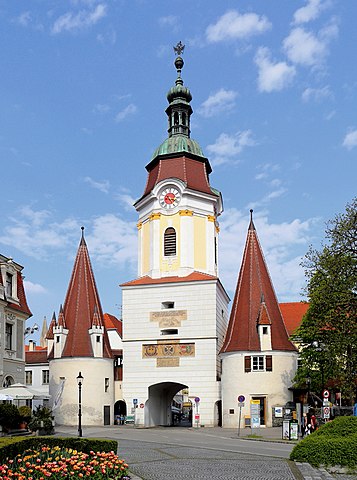
Deutsch: Das Steiner Tor in der niederösterreichischen Bezirkshauptstadt Krems an der Donau.
Das einzige erhaltene von den ehemals 4 Stadttoren ist das Wahrzeichen der Stadt und war früher Teil der Stadtmauer, die mittlerweile abgetragen ist. Das untere Stockwerk des mächtigen Rechteckturmes sowie die flankierenden Trabantentürme stammen aus dem Ende des 15. Jahrhunderts. Der barocke Turmaufbau erfolgte in der Regierungszeit Maria Theresias (um 1750). |
| Date | |
| Source | Own work |
| Author | C.Stadler/Bwag |
| Permission (Reusing this file) |
Deutsch: Hallo, du darfst mein Foto kostenlos nutzen, aber nenne mich bitte als Fotograf, beispielsweise „Foto: C.Stadler/Bwag“ oder © C.Stadler/Bwag; CC-BY-SA-4.0. Auf mehr Angaben bestehe ich nicht - im Gegensatz zu manch anderen, die die Vorgaben der unten angeführten Lizenzierung auf Punkt und Beistrich einfordern. English: Feel free to use my photos, but please mention me as the author like © C.Stadler/Bwag or © C.Stadler/Bwag; CC-BY-SA-4.0 (that's good enough) and if you want send me a message: bwag@gmx.net. |
| Other versions |
|
.JPG)
.JPG&action=edit§ion=1)
| Object location | | View this and other nearby images on: OpenStreetMap |
|---|
.JPG¶ms=048.409850_N_0015.596490_E_globe:Earth_class:object_type:object__&language=en)
| Camera location | | View this and other nearby images on: OpenStreetMap |
|---|
.JPG¶ms=048.409633_N_0015.595973_E_globe:Earth_type:camera_alt:202.2_source:exif_&language=en)
Licensing[edit]
.JPG&action=edit§ion=2)
I, the copyright holder of this work, hereby publish it under the following license:
This file is licensed under the Creative Commons Attribution-Share Alike 4.0 International license.
- You are free:
- to share – to copy, distribute and transmit the work
- to remix – to adapt the work
- Under the following conditions:
- attribution – You must give appropriate credit, provide a link to the license, and indicate if changes were made. You may do so in any reasonable manner, but not in any way that suggests the licensor endorses you or your use.
- share alike – If you remix, transform, or build upon the material, you must distribute your contributions under the same or compatible license as the original.
This image has been assessed using the Quality image guidelines and is considered a Quality image.
|
File history
Click on a date/time to view the file as it appeared at that time.
| Date/Time | Thumbnail | Dimensions | User | Comment | |
|---|---|---|---|---|---|
| current | 07:58, 22 June 2021 | | 2,844 × 3,822 (8.27 MB) | Bwag (talk | contribs) | b |
| 19:30, 14 April 2016 |  | 2,844 × 3,822 (8.15 MB) | Bwag (talk | contribs) | {{Information |Description= {{de|1= Das Steiner Tor in der niederösterreichischen Bezirkshauptstadt Krems an der Donau.<br/>Das einzige erhaltene von den ehemals 4 Stadttoren ist das Wahrzeichen der Stad... |
You cannot overwrite this file.
File usage on Commons
The following 8 pages use this file:
- User talk:Bwag
- User talk:Manfred Kuzel/Archive/2017
- Commons:Files used on RegiowikiAT/7
- Commons:Files used on Wikimedia Österreich Mitglieder/1
- Commons:Quality images/Subject/Architecture/Religious/Churches/Archive 2017-2
- Commons:Quality images candidates/Archives July 21 2017
- File:Krems - Steinertor (2).JPG
- Category:Steiner Tor, Krems
File usage on other wikis
The following other wikis use this file:
- Usage on ban.wikipedia.org
- Usage on bg.wikipedia.org
- Usage on ca.wikipedia.org
- Usage on cs.wikipedia.org
- Usage on de.wikipedia.org
- Usage on el.wikipedia.org
- Usage on en.wikipedia.org
- Usage on en.wikivoyage.org
- Usage on et.wikipedia.org
- Usage on fr.wikipedia.org
- Usage on he.wikipedia.org
- Usage on hu.wikipedia.org
- Usage on hy.wikipedia.org
- Usage on is.wikipedia.org
- Usage on pl.wikipedia.org
- Usage on sl.wikipedia.org
- Usage on uk.wikipedia.org
- Usage on www.wikidata.org
- Usage on zh.wikipedia.org
.JPG&oldid=706304625)