File:Kosovo map-fr.svg
Jump to navigation
Jump to search

Size of this PNG preview of this SVG file: 582 × 599 pixels. Other resolutions: 233 × 240 pixels | 466 × 480 pixels | 746 × 768 pixels | 994 × 1,024 pixels | 1,989 × 2,048 pixels | 1,777 × 1,830 pixels.
Original file (SVG file, nominally 1,777 × 1,830 pixels, file size: 3.75 MB)
Captions
Captions
Add a one-line explanation of what this file represents
Summary[edit]
| Description |
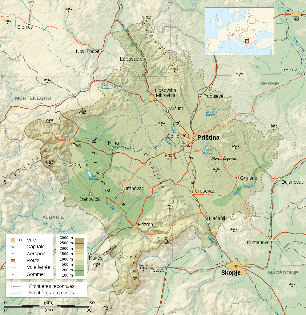
Čeština: Mapa Kosova. Dansk: Kort over Kosovo. Deutsch: Karte des Kosovo. English: Map of the Kosovo. Español: Mapa de Kosovo. Français : Carte du Kosovo. Italiano: Mappa del Kosovo. Magyar: Koszovó térképe albán és szerb helységnevekkel. Polski: Mapa Kosowa. Română: Harta provinciei Kosovo Svenska: Karta över Kosovo, engelskspråkig. Türkçe: Kosova haritası. Русский: Карта Косово, на английском. 日本語: コソボの地図]]。 |
| Date | |
| Source |
Logiciels utilisés :
Autres données :
|
| Author | Sémhur |
| Other versions |
[] |
| Attribution (required by the license) | © Sémhur / Wikimedia Commons / |
| SVG development |

| Camera location | | View this and other nearby images on: OpenStreetMap |
|---|
Licensing[edit]
I, the copyright holder of this work, hereby publish it under the following licenses:
| Copyleft: This work of art is free; you can redistribute it and/or modify it according to terms of the Free Art License. You will find a specimen of this license on the Copyleft Attitude site as well as on other sites. |
This file is licensed under the Creative Commons Attribution-Share Alike Attribution-Share Alike 4.0 International, 3.0 Unported, 2.5 Generic, 2.0 Generic and 1.0 Generic license.
- You are free:
- to share – to copy, distribute and transmit the work
- to remix – to adapt the work
- Under the following conditions:
- attribution – You must give appropriate credit, provide a link to the license, and indicate if changes were made. You may do so in any reasonable manner, but not in any way that suggests the licensor endorses you or your use.
- share alike – If you remix, transform, or build upon the material, you must distribute your contributions under the same or compatible license as the original.
You may select the license of your choice.
File history
Click on a date/time to view the file as it appeared at that time.
| Date/Time | Thumbnail | Dimensions | User | Comment | |
|---|---|---|---|---|---|
| current | 13:16, 16 May 2008 | | 1,777 × 1,830 (3.75 MB) | Sémhur (talk | contribs) | Mise en conformité avec les autres cartes de la série (frontières reconnues - frontières litigieuses) |
| 11:13, 4 March 2008 |  | 1,777 × 1,830 (3.73 MB) | Sémhur (talk | contribs) | Neutralisation de la carte par suppression des frontières du Kosovo, textes plus lisibles (plus gros et plus sombres), corrections toponymiques | |
| 22:55, 24 February 2008 |  | 1,777 × 1,830 (3.73 MB) | Sémhur (talk | contribs) | {{Information |Description= {{en| French Map of the Kosovo.}} {{fr| Carte du Kosovo.}} |Source=Travail personnel. {{clr}} Sources : * Fond de carte : [http://www2.jpl.nasa.gov/srtm NASA Shuttle Radar Topography Mission] (doma |
You cannot overwrite this file.
File usage on Commons
The following page uses this file:
File usage on other wikis
The following other wikis use this file:
- Usage on als.wikipedia.org
- Usage on ang.wikipedia.org
- Usage on ast.wikipedia.org
- Usage on azb.wikipedia.org
- Usage on bat-smg.wikipedia.org
- Usage on br.wikipedia.org
- Usage on ca.wikipedia.org
- Usage on diq.wikipedia.org
- Usage on el.wikipedia.org
- Usage on eo.wikipedia.org
- Usage on et.wikipedia.org
- Usage on fr.wikipedia.org
- Usage on la.wikipedia.org
- Usage on mk.wikipedia.org
- Usage on no.wikipedia.org
- Usage on sq.wikipedia.org
- Usage on sr.wikipedia.org