File:KiryatGat.png
Jump to navigation
Jump to search
Size of this preview: 750 × 599 pixels. Other resolutions: 300 × 240 pixels | 601 × 480 pixels | 877 × 701 pixels.
Original file (877 × 701 pixels, file size: 28 KB, MIME type: image/png)
Captions
Captions
Add a one-line explanation of what this file represents
Summary
[edit]
| Description |
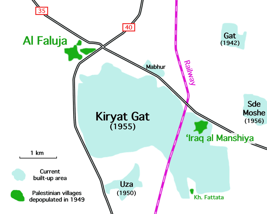
English: Kiryat Gat, Israel, showing location of Palestinian villages depopulated in 1949.
العربية: كريات جات ، إسرائيل ، تظهر موقع القرى الفلسطينية التي تم إخلاء سكانها عام 1949. |
| Date | |
| Source | Own work |
| Author | Zero0000 |
Licensing
[edit]
I, the copyright holder of this work, hereby publish it under the following license:
This file is licensed under the Creative Commons Attribution-Share Alike 4.0 International license.
- You are free:
- to share – to copy, distribute and transmit the work
- to remix – to adapt the work
- Under the following conditions:
- attribution – You must give appropriate credit, provide a link to the license, and indicate if changes were made. You may do so in any reasonable manner, but not in any way that suggests the licensor endorses you or your use.
- share alike – If you remix, transform, or build upon the material, you must distribute your contributions under the same or compatible license as the original.
File history
Click on a date/time to view the file as it appeared at that time.
| Date/Time | Thumbnail | Dimensions | User | Comment | |
|---|---|---|---|---|---|
| current | 10:17, 28 March 2015 | | 877 × 701 (28 KB) | Zero0000 (talk | contribs) | Add years. Not sure about Mabhur. Pre-1956 according to maps. |
| 10:04, 28 March 2015 |  | 877 × 701 (26 KB) | Zero0000 (talk | contribs) | User created page with UploadWizard |
You cannot overwrite this file.
File usage on Commons
The following page uses this file:
File usage on other wikis
The following other wikis use this file:
- Usage on ar.wikipedia.org
- Usage on en.wikipedia.org
- Usage on ja.wikipedia.org