File:Kirov Kalujskoe Namesnichestvo Atlas Rossijskoy Imperii 1792.png
Jump to navigation
Jump to search
No higher resolution available.
Kirov_Kalujskoe_Namesnichestvo_Atlas_Rossijskoy_Imperii_1792.png (278 × 125 pixels, file size: 29 KB, MIME type: image/png)
Captions
Captions
Add a one-line explanation of what this file represents
Summary
[edit]| Description |
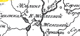
Русский: Фрагмент карты взятый из "Российский атлас, из сорока четырех карт состоящий и на сорок два наместничества империю разделяющий" — большого настольного атласа справочного характера, изданного в 1792 году. На карте изображены деревни Верхний и Нижний Железной(ныне г. Киров Калужской области)
English: Fragment of Kaluga region from "Russian atlas" published in 1792 |
| Date | |
| Source | http://www.runivers.ru/lib/atlas/atlas4296/43128/ |
| Author | А. Вильбрехт гравировка Алексей Савинков, И. Леонов; вырезка Т. Михайлов |
Licensing
[edit]|
This work is in the public domain in its country of origin and other countries and areas where the copyright term is the author's life plus 100 years or fewer. | |
| This file has been identified as being free of known restrictions under copyright law, including all related and neighboring rights. | |

File history
Click on a date/time to view the file as it appeared at that time.
| Date/Time | Thumbnail | Dimensions | User | Comment | |
|---|---|---|---|---|---|
| current | 15:46, 27 July 2013 | | 278 × 125 (29 KB) | Бровкин (talk | contribs) | {{Information |Description = {{ru| Фрагмент карты взятый из "Российский атлас, из сорока четырех карт состоящий и на сорок два наместничества империю ра... |
You cannot overwrite this file.
File usage on Commons
There are no pages that use this file.
File usage on other wikis
The following other wikis use this file:
- Usage on ru.wikipedia.org