File:Kingdom of Numidia-02.png
Jump to navigation
Jump to search

Size of this preview: 800 × 346 pixels. Other resolutions: 320 × 138 pixels | 640 × 277 pixels | 1,024 × 443 pixels | 2,246 × 971 pixels.
Original file (2,246 × 971 pixels, file size: 495 KB, MIME type: image/png)
Captions
Captions
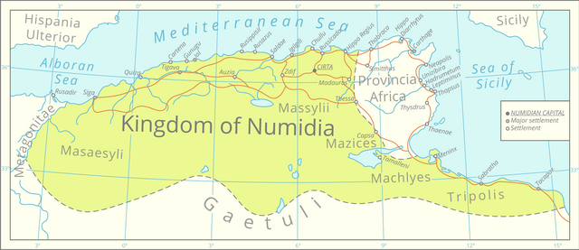
A map of the Kingdom of Numidia at it's height
Summary[edit]
| Description |
English: This map was assembled using the boundaries of this map, Roman road data from this [1] dataset, river and lake data from the Pergamon Atlas as well as settlement significance from the Barrington Atlas.
The graphics were assembled in QGIS and processed in Adobe Illustrator. All data is projected in the Lambert azimuthal equal-area projection. |
| Date | |
| Source | Own work |
| Author | Cattette |
Licensing[edit]
I, the copyright holder of this work, hereby publish it under the following license:
This file is licensed under the Creative Commons Attribution 4.0 International license.
- You are free:
- to share – to copy, distribute and transmit the work
- to remix – to adapt the work
- Under the following conditions:
- attribution – You must give appropriate credit, provide a link to the license, and indicate if changes were made. You may do so in any reasonable manner, but not in any way that suggests the licensor endorses you or your use.
File history
Click on a date/time to view the file as it appeared at that time.
| Date/Time | Thumbnail | Dimensions | User | Comment | |
|---|---|---|---|---|---|
| current | 00:26, 30 March 2021 | | 2,246 × 971 (495 KB) | Cattette (talk | contribs) | Uploaded own work with UploadWizard |
You cannot overwrite this file.
File usage on Commons
The following 4 pages use this file:
File usage on other wikis
The following other wikis use this file:
- Usage on ar.wikipedia.org
- Usage on ast.wikipedia.org
- Usage on az.wikipedia.org
- Usage on bs.wikipedia.org
- Usage on ca.wikipedia.org
- Usage on cs.wikipedia.org
- Usage on de.wikipedia.org
- Usage on el.wikipedia.org
- Usage on en.wikipedia.org
- Usage on eo.wikipedia.org
- Usage on fa.wikipedia.org
- Usage on fi.wikipedia.org
- Usage on fr.wikipedia.org
- Usage on fy.wikipedia.org
- Usage on gl.wikipedia.org
- Usage on ha.wikipedia.org
- Usage on ia.wikipedia.org
- Usage on ja.wikipedia.org
- Usage on kab.wikipedia.org
- Usage on ko.wikipedia.org
- Usage on lt.wikipedia.org
- Usage on lv.wikipedia.org
- Usage on mk.wikipedia.org
- Usage on pl.wikipedia.org
- Usage on rue.wikipedia.org
- Usage on sl.wikipedia.org
- Usage on www.wikidata.org