File:Kildwick & Crosshills 1st railway station (site), Yorkshire (geograph 5667518).jpg
Jump to navigation
Jump to search

Size of this preview: 800 × 600 pixels. Other resolutions: 320 × 240 pixels | 640 × 480 pixels | 1,024 × 768 pixels | 1,280 × 960 pixels | 1,600 × 1,200 pixels.
Original file (1,600 × 1,200 pixels, file size: 570 KB, MIME type: image/jpeg)
Captions
Captions
Add a one-line explanation of what this file represents
Summary
[edit],_Yorkshire_(geograph_5667518).jpg&action=edit§ion=1)
| Description |
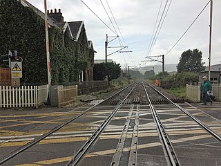
English: Kildwick & Crosshills 1st railway station (site), Yorkshire Opened in 1847 as 'Kildwick' by the Leeds & Bradford Extension Railway, soon to be part of the Midland Railway, on the line from Shipley to Skipton. It was renamed 'Kildwick & Cross Hills" in 1863 and to "Kildwick and Crosshills" in 1884, before closing in 1889 when it was replaced by a new station some 400m further west. That in turn also closed in 1965. View west (in torrential rain!) towards the 2nd station (site) and Skipton. Remarkably the 1st station building has survived. |
| Date | |
| Source | From geograph.org.uk |
| Author | Nigel Thompson |
| Permission (Reusing this file) |
Creative Commons Attribution Share-alike license 2.0 |
| Attribution (required by the license) | Nigel Thompson / Kildwick & Crosshills 1st railway station (site), Yorkshire / |
| Camera location | | View this and other nearby images on: OpenStreetMap |
|---|
,_Yorkshire_(geograph_5667518).jpg¶ms=053.903502_N_-001.983222_E_globe:Earth_type:camera_source:geograph-osgb36(SE01204526)_heading:270.00&language=en)
| Object location | | View this and other nearby images on: OpenStreetMap |
|---|
,_Yorkshire_(geograph_5667518).jpg¶ms=053.903590_N_-001.984130_E_globe:Earth_class:object_type:object_source:geograph-osgb36(SE01144527)_heading:270.00&language=en)
Licensing
[edit],_Yorkshire_(geograph_5667518).jpg&action=edit§ion=2)

|
This image was taken from the Geograph project collection. See this photograph's page on the Geograph website for the photographer's contact details. The copyright on this image is owned by Nigel Thompson and is licensed for reuse under the Creative Commons Attribution-ShareAlike 2.0 license.
|
This file is licensed under the Creative Commons Attribution-Share Alike 2.0 Generic license.
Attribution: Nigel Thompson
- You are free:
- to share – to copy, distribute and transmit the work
- to remix – to adapt the work
- Under the following conditions:
- attribution – You must give appropriate credit, provide a link to the license, and indicate if changes were made. You may do so in any reasonable manner, but not in any way that suggests the licensor endorses you or your use.
- share alike – If you remix, transform, or build upon the material, you must distribute your contributions under the same or compatible license as the original.
File history
Click on a date/time to view the file as it appeared at that time.
| Date/Time | Thumbnail | Dimensions | User | Comment | |
|---|---|---|---|---|---|
| current | 11:08, 15 August 2019 | | 1,600 × 1,200 (570 KB) | Lamberhurst (talk | contribs) | Transferred from geograph.co.uk using [https://tools.wmflabs.org/geograph2commons/ geograph2commons] |
You cannot overwrite this file.
File usage on Commons
The following page uses this file:
,_Yorkshire_(geograph_5667518).jpg&oldid=714133777)