File:Kiekebuscher Wehr, Cottbus (water level indicator.png
Jump to navigation
Jump to search

Size of this preview: 450 × 600 pixels. Other resolutions: 180 × 240 pixels | 360 × 480 pixels | 576 × 768 pixels | 768 × 1,024 pixels | 1,944 × 2,592 pixels.
Original file (1,944 × 2,592 pixels, file size: 8.08 MB, MIME type: image/png)
Captions
Captions
Add a one-line explanation of what this file represents
Summary
[edit]
| Description |
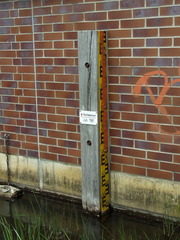
English: Kiekebuscher Wehr, which was built between 2002-2002 and replaced an earlier structure slightly further upstream, is located roughly on the administrative boundaries between Cottbus-Spremberger Vorstadt, -Sandow as well as -Branitz. It connects Volkspark Cottbus with Branitz and carries three long-distance cycling routes as well as local hiking trails across the river Spree. Last major refurbishment of the weir was undertaken in 2017/2018. Shown here is the water level indicator and all-time high-water mark during Spreehochwasser 1981. |
| Date | |
| Source | Own work |
| Author | Trio3D |
| Camera location | | View this and other nearby images on: OpenStreetMap |
|---|
This file is licensed under the Creative Commons Attribution-Share Alike 4.0 International license.
- You are free:
- to share – to copy, distribute and transmit the work
- to remix – to adapt the work
- Under the following conditions:
- attribution – You must give appropriate credit, provide a link to the license, and indicate if changes were made. You may do so in any reasonable manner, but not in any way that suggests the licensor endorses you or your use.
- share alike – If you remix, transform, or build upon the material, you must distribute your contributions under the same or compatible license as the original.
File history
Click on a date/time to view the file as it appeared at that time.
| Date/Time | Thumbnail | Dimensions | User | Comment | |
|---|---|---|---|---|---|
| current | 15:10, 5 May 2019 | | 1,944 × 2,592 (8.08 MB) | Trio3D (talk | contribs) | {{Information |description ={{en|1=Kiekebuscher Wehr, which was built between 2002-2002 and replaced an earlier structure slightly further upstream, is located roughly on the administrative boundaries between Cottbus-Spremberger Vorstadt, -Sandow as well as -Branitz. It connects Volkspark Cottbus with Branitz and carries three long-distance cycling routes as well as local hiking trails across the river Spree. Last major refurbishment of the weir was undertaken in 2017/2018.<br><br>Shown her... |
You cannot overwrite this file.
File usage on Commons
The following page uses this file: