File:Kerguelen topographic map-bg.svg
Jump to navigation
Jump to search

Size of this PNG preview of this SVG file: 576 × 599 pixels. Other resolutions: 231 × 240 pixels | 461 × 480 pixels | 738 × 768 pixels | 984 × 1,024 pixels | 1,968 × 2,048 pixels | 1,840 × 1,915 pixels.
Original file (SVG file, nominally 1,840 × 1,915 pixels, file size: 2.33 MB)
Captions
Captions
Add a one-line explanation of what this file represents
| Description |
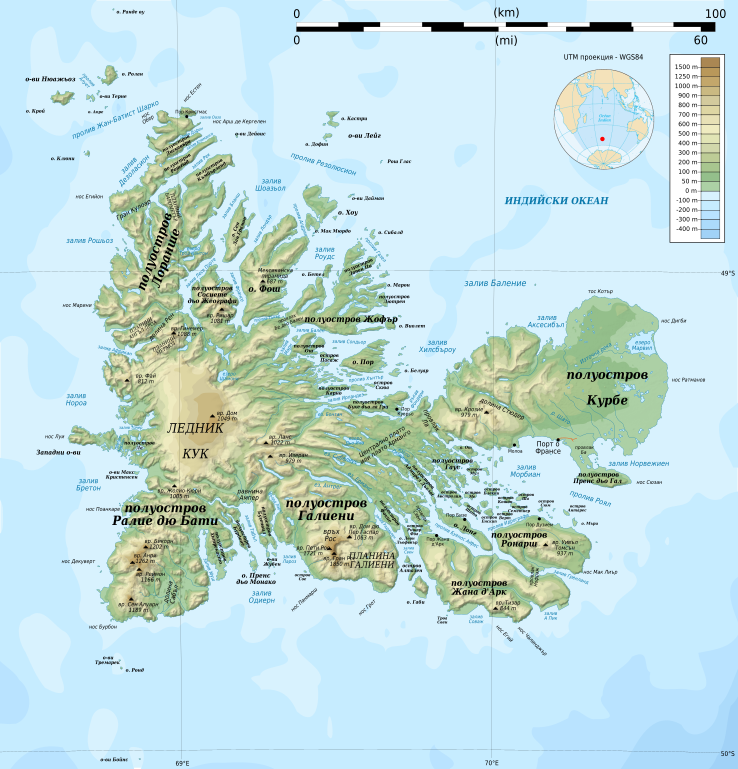
English: Topographic map of the Kerguelen Islands, Indian Ocean, France. Use the PNG version for inserting into articles as it is lighter. Français : Carte topographique des îles Kerguelen. Utiliser la version PNG dans les articles pour un chargement plus rapide et un meilleur rendu. * UTM projection, WGS84 datum * The shaded relief is an embedded raster image, delete it to make the file smaller. |
| Date | (UTC) |
| Source | |
| Author |
|
I, the copyright holder of this work, hereby publish it under the following licenses:
This file is licensed under the Creative Commons Attribution-Share Alike 3.0 Unported, 2.5 Generic, 2.0 Generic and 1.0 Generic license.
- You are free:
- to share – to copy, distribute and transmit the work
- to remix – to adapt the work
- Under the following conditions:
- attribution – You must give appropriate credit, provide a link to the license, and indicate if changes were made. You may do so in any reasonable manner, but not in any way that suggests the licensor endorses you or your use.
- share alike – If you remix, transform, or build upon the material, you must distribute your contributions under the same or compatible license as the original.

|
Permission is granted to copy, distribute and/or modify this document under the terms of the GNU Free Documentation License, Version 1.2 or any later version published by the Free Software Foundation; with no Invariant Sections, no Front-Cover Texts, and no Back-Cover Texts. A copy of the license is included in the section entitled GNU Free Documentation License. |
You may select the license of your choice.
Original upload log[edit]
This image is a derivative work of the following images:
- File:Kerguelen_topographic_map-fr.svg licensed with Cc-by-sa-3.0,2.5,2.0,1.0, GFDL
- 2010-04-25T14:12:49Z Korrigan 1840x1915 (2439890 Bytes) Correcting roads after advice from [[User:B.navez|B.navez]]
- 2009-03-17T21:02:42Z Korrigan 1840x1915 (2440538 Bytes) Typo ("prequ'île")
- 2009-03-17T19:46:33Z Korrigan 1840x1915 (2440559 Bytes) {{Information |Description={{en|Topographic map of the Kerguelen Islands, Indian Ocean, France. Use the [[:File:Kerguelen_topographic_map-fr.png|PNG version]] for inserting into articles as it is lighter.}} {{fr|Carte topogra
Uploaded with derivativeFX
File history
Click on a date/time to view the file as it appeared at that time.
| Date/Time | Thumbnail | Dimensions | User | Comment | |
|---|---|---|---|---|---|
| current | 11:02, 15 May 2010 | | 1,840 × 1,915 (2.33 MB) | Nk (talk | contribs) | |
| 11:00, 15 May 2010 |  | 1,840 × 1,915 (2.33 MB) | Nk (talk | contribs) | {{Information |Description={{en|Topographic map of the Kerguelen Islands, Indian Ocean, France. Use the PNG version for inserting into articles as it is lighter.}} {{fr|Carte topographique des îles Kerguelen. Ut |
You cannot overwrite this file.
File usage on Commons
There are no pages that use this file.
File usage on other wikis
The following other wikis use this file:
- Usage on bg.wikipedia.org