File:Katmai National Park Geologic Map.png
Jump to navigation
Jump to search

Size of this preview: 800 × 331 pixels. Other resolutions: 320 × 132 pixels | 640 × 265 pixels | 1,829 × 756 pixels.
Original file (1,829 × 756 pixels, file size: 1.9 MB, MIME type: image/png)
Captions
Captions
Add a one-line explanation of what this file represents
Summary
[edit]
| Description |
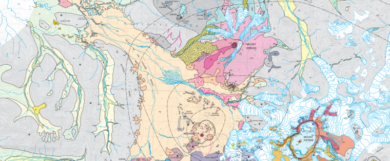
English: Katmai National Park Geologic Map, where nig is the Episode I valley-filling ignimbrite of 6-7 June 1912, bu is Late Jurassic Naknek Formation basement rock, nrd is the Novarupta rhyolite dome and ap its pumiceous alluvium, while ks, kbn and kn are Mount Katmai Late Pleistocene andesites and khi is the Horseshoe Island dacite. Mount Griggs' andesites are represented by gma, gyl and gyo, while gdo is the Knife Peak debris avalanche, and npe are phreatic explosion deposits. The Falling Mountain dacite dome is represented by tfc and glacial till deposits are represented by gh for Holocene and gp for Late Pleistocene. |
| Date | |
| Source | Geologic Map of the Katmai Cluster, Katmai National Park, Alaska, USGS Geologic Investigations Series I-2778 |
| Author | Wes Hildreth and Judy Fierstein |
Licensing
[edit]
This work is in the public domain in the United States because it is a work prepared by an officer or employee of the United States Government as part of that person’s official duties under the terms of Title 17, Chapter 1, Section 105 of the US Code.
Note: This only applies to original works of the Federal Government and not to the work of any individual U.S. state, territory, commonwealth, county, municipality, or any other subdivision. This template also does not apply to postage stamp designs published by the United States Postal Service since 1978. (See § 313.6(C)(1) of Compendium of U.S. Copyright Office Practices). It also does not apply to certain US coins; see The US Mint Terms of Use.
|
 | |
| This file has been identified as being free of known restrictions under copyright law, including all related and neighboring rights. | ||
File history
Click on a date/time to view the file as it appeared at that time.
| Date/Time | Thumbnail | Dimensions | User | Comment | |
|---|---|---|---|---|---|
| current | 17:22, 3 August 2018 | | 1,829 × 756 (1.9 MB) | Pi3.124 (talk | contribs) | removed white space |
| 17:08, 3 August 2018 |  | 1,825 × 1,023 (1.79 MB) | Pi3.124 (talk | contribs) | User created page with UploadWizard |
You cannot overwrite this file.
File usage on Commons
The following page uses this file:
File usage on other wikis
The following other wikis use this file:
- Usage on en.wikipedia.org
Metadata
Categories:
- Geological maps of Katmai National Park
- Valley of Ten Thousand Smokes
- Geological maps of Alaska
- Geology of Katmai National Park
- Naknek Formation
- Episode I valley-filling ignimbrite (Novarupta 1912)
- Maps of Novarupta
- Mount Katmai Pleistocene andesites
- Horseshoe Island Dacite
- Mount Griggs' andesites
- Pumiceous alluvium of Novarupta
- Knife Peak Debris Avalanche
- Phreatic explosion deposits in Katmai National Park
- Falling Mountain (Katmai)
- Holocene glacial till deposits in Alaska
- Pleistocene glacial till deposits in Alaska
- Maps of the Katmai Caldera
- Mount Katmai
- Mount Griggs
- Maps of glaciers of Alaska
- Maps of rivers in Alaska
- Glacial outwash plains in Alaska