File:Karte von Deutschland zur Übersicht der Eisenbahnen einschliesslich der projectirten Linien, der Gewässer und hauptsächlisten Strassen.jpg
Jump to navigation
Jump to search

Size of this preview: 800 × 587 pixels. Other resolutions: 320 × 235 pixels | 640 × 469 pixels | 1,024 × 751 pixels | 1,280 × 939 pixels | 2,560 × 1,878 pixels | 14,845 × 10,889 pixels.
Original file (14,845 × 10,889 pixels, file size: 30.39 MB, MIME type: image/jpeg)
Captions
Captions
Add a one-line explanation of what this file represents
Summary[edit]
| Warning | The original file is very high-resolution. It might not load properly or could cause your browser to freeze when opened at full size. |
|---|
| Description |
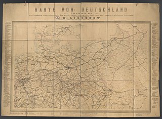
Deutsch: 1 Kt. : Grenzen kolor. (105 x 67 cm, gefaltet 21 x 30 cm) ; Maßstab 1:1.250.000 ; Koordinaten E 5°47'00"-E 25°31'00"/N 56°16'00"-N 48°39'00" ; Maßstab in graph. Form (geogr. Meilen). - Titel und Maßstab oberhalb des Kt.-Feldes. - Legende unterhalb des Kt.-Feldes. - Tabelle der Bahnlinien rechts und links vom Kt.-Feld. - Mit Bahnlinien verschiedener Ausbaustufen. - Mit Leinenrücken. - Ohne Relief |
| Date | |
| Source | Leibniz-Institut für Länderkunde e.V., Leipzig |
| Author | Liebenow, Wilhelm |
Altkarte ; Verkehrskarte ; Eisenbahn ; Straße
Licensing[edit]
| This file is made available under the Creative Commons CC0 1.0 Universal Public Domain Dedication. | |
| The person who associated a work with this deed has dedicated the work to the public domain by waiving all of their rights to the work worldwide under copyright law, including all related and neighboring rights, to the extent allowed by law. You can copy, modify, distribute and perform the work, even for commercial purposes, all without asking permission.
|
File history
Click on a date/time to view the file as it appeared at that time.
| Date/Time | Thumbnail | Dimensions | User | Comment | |
|---|---|---|---|---|---|
| current | 12:55, 6 December 2018 | | 14,845 × 10,889 (30.39 MB) | Higgenhorscht (talk | contribs) | User created page with UploadWizard |
You cannot overwrite this file.
File usage on Commons
There are no pages that use this file.