File:Karte Römischer Gutshof Büßlingen.png
Jump to navigation
Jump to search

Size of this preview: 458 × 599 pixels. Other resolutions: 183 × 240 pixels | 367 × 480 pixels | 587 × 768 pixels | 782 × 1,024 pixels | 2,203 × 2,883 pixels.
Original file (2,203 × 2,883 pixels, file size: 887 KB, MIME type: image/png)
Captions
Captions
Add a one-line explanation of what this file represents
Summary
[edit]
| Description |
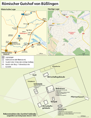
Deutsch: Karte des Römischen Gutshofs bei Büßlingen |
|||
| Date | see file history | |||
| Source |
Own work, using
|
|||
| Author | Maximilian Dörrbecker (Chumwa) | |||
| Permission (Reusing this file) |
This file is licensed under the Creative Commons Attribution-Share Alike 2.0 Generic license.
Sie dürfen das Bild zu den folgenden Bedingungen nutzen:
|
File history
Click on a date/time to view the file as it appeared at that time.
| Date/Time | Thumbnail | Dimensions | User | Comment | |
|---|---|---|---|---|---|
| current | 06:12, 13 November 2013 | | 2,203 × 2,883 (887 KB) | Chumwa (talk | contribs) | |
| 18:54, 11 November 2013 |  | 2,467 × 1,736 (750 KB) | Chumwa (talk | contribs) | == {{int:filedesc}} == {{Information |Description = {{de|1=Karte des Römischen Gutshofs bei Büßlingen}} |Source={{own}}, using * OpenStreetMap for the inset "Heutige Lage" * ihis map by {{U|Ziegelbrenner}} for the inset "... |
You cannot overwrite this file.
File usage on Commons
The following page uses this file:
File usage on other wikis
The following other wikis use this file:
- Usage on de.wikipedia.org