File:Karte EU-Erweiterungen.png
Jump to navigation
Jump to search

Size of this preview: 696 × 600 pixels. Other resolutions: 279 × 240 pixels | 557 × 480 pixels | 892 × 768 pixels | 1,189 × 1,024 pixels | 1,392 × 1,199 pixels.
Original file (1,392 × 1,199 pixels, file size: 394 KB, MIME type: image/png)
Captions
Captions
Add a one-line explanation of what this file represents
Summary[edit]
| Description |
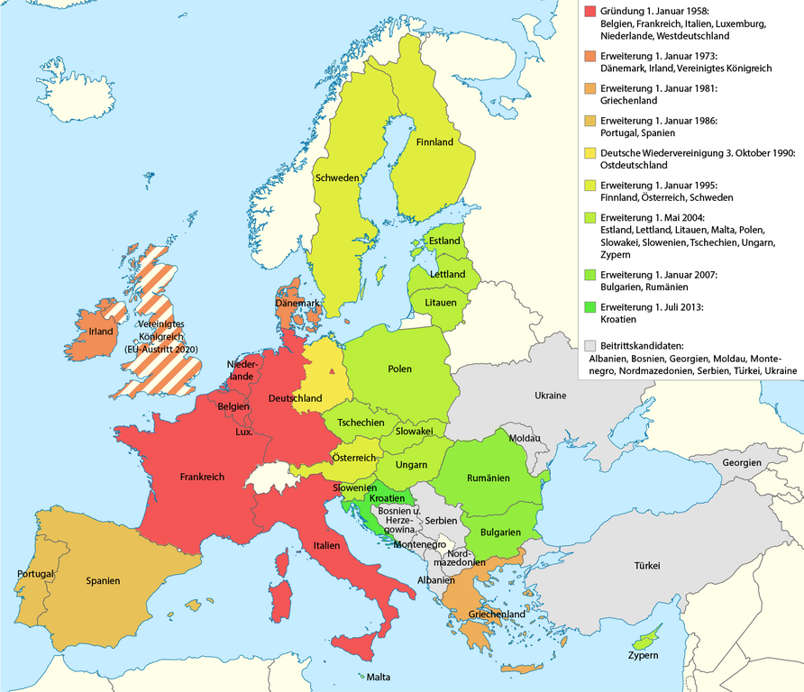
Deutsch: Erweiterungen der EU |
| Date | see file history |
| Source | Own work, using this base map by Alexrk2 |
| Author | Maximilian Dörrbecker (Chumwa) |
| Permission (Reusing this file) |
This file is licensed under the Creative Commons Attribution-Share Alike 2.0 Generic license.
|
| Other versions |
|


File history
Click on a date/time to view the file as it appeared at that time.
| Date/Time | Thumbnail | Dimensions | User | Comment | |
|---|---|---|---|---|---|
| current | 23:20, 17 December 2023 | | 1,392 × 1,199 (394 KB) | Iktsokh (talk | contribs) | Georgia is recognized as an official candidate. |
| 18:29, 16 December 2022 |  | 1,392 × 1,199 (254 KB) | NordNordWest (talk | contribs) | + Bosnien-Herzegowina | |
| 16:35, 5 December 2022 |  | 1,392 × 1,199 (253 KB) | NordNordWest (talk | contribs) | Brexit | |
| 10:52, 4 December 2022 |  | 1,392 × 1,199 (241 KB) | NordNordWest (talk | contribs) | upd 2022 | |
| 20:17, 7 June 2015 |  | 1,392 × 1,199 (232 KB) | Cmdrjameson (talk | contribs) | Compressed with pngout. Reduced by 125kB (35% decrease). | |
| 05:11, 26 March 2015 |  | 1,392 × 1,199 (357 KB) | Chumwa (talk | contribs) | Albanien ist jetzt Beitrittskandidat | |
| 18:27, 16 March 2015 |  | 1,392 × 1,199 (358 KB) | Chumwa (talk | contribs) | ||
| 18:25, 16 March 2015 |  | 1,392 × 1,199 (357 KB) | Chumwa (talk | contribs) | Island hat seine Beitrittskandidatur zurückgezogen | |
| 22:28, 17 December 2013 |  | 1,392 × 1,199 (357 KB) | Chumwa (talk | contribs) | ||
| 12:32, 17 December 2013 |  | 1,392 × 1,199 (239 KB) | Kopiersperre (talk | contribs) | OptiPNG: Traffic reduziert |
You cannot overwrite this file.
File usage on Commons
The following 5 pages use this file:
File usage on other wikis
The following other wikis use this file:
- Usage on de.wikipedia.org
- Erweiterung der Europäischen Union
- Geschichte der Europäischen Union
- Benutzer:Chumwa
- Außengrenzen der Europäischen Union
- Wikipedia Diskussion:Kartenwerkstatt/Archiv6
- Wikipedia:Kartenwerkstatt/Archiv/2013-12
- Wikipedia:Kartenwerkstatt/Karte des Tages/Galerie
- Benutzer:Chumwa/SomeOfMyFiles
- Wikipedia:Hauptseite/Archiv/1. Januar 2020