File:Karte-Kosovo-Eisenbahnnetz.png
Jump to navigation
Jump to search

Size of this preview: 582 × 599 pixels. Other resolutions: 233 × 240 pixels | 466 × 480 pixels | 746 × 768 pixels | 994 × 1,024 pixels | 1,500 × 1,545 pixels.
Original file (1,500 × 1,545 pixels, file size: 2.97 MB, MIME type: image/png)
Captions
Captions
Add a one-line explanation of what this file represents
Summary[edit]
| Description |
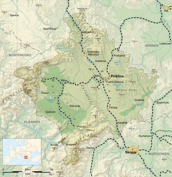
Deutsch: Karte der Bahnstrecken im Kosovo, deutsche Version English: Map of the railway network in Kosovo, German version Français : Carte du chemin de fer de Kosovo, en allemand. |
| Date | (UTC) |
| Source |
This file was derived from: Kosovo map-de.svg:  |
| Author |
|
| Other versions | SVG-Version |
| This is a retouched picture, which means that it has been digitally altered from its original version. The original can be viewed here: Kosovo map-de.svg:
|
Licensing[edit]
I, the copyright holder of this work, hereby publish it under the following licenses:
This file is licensed under the Creative Commons Attribution-Share Alike 3.0 Unported, 2.5 Generic, 2.0 Generic and 1.0 Generic license.
- You are free:
- to share – to copy, distribute and transmit the work
- to remix – to adapt the work
- Under the following conditions:
- attribution – You must give appropriate credit, provide a link to the license, and indicate if changes were made. You may do so in any reasonable manner, but not in any way that suggests the licensor endorses you or your use.
- share alike – If you remix, transform, or build upon the material, you must distribute your contributions under the same or compatible license as the original.

|
Permission is granted to copy, distribute and/or modify this document under the terms of the GNU Free Documentation License, Version 1.2 or any later version published by the Free Software Foundation; with no Invariant Sections, no Front-Cover Texts, and no Back-Cover Texts. A copy of the license is included in the section entitled GNU Free Documentation License. |
You may select the license of your choice.
Original upload log[edit]
This image is a derivative work of the following images:
- File:Kosovo_map-de.svg licensed with Cc-by-sa-3.0,2.5,2.0,1.0, GFDL
- 2012-12-18T22:38:14Z Muns 1777x1830 (3801768 Bytes) Anpassung von Namen gem. Diskussion in der Kartenwerkstatt
- 2008-04-20T10:16:07Z NordNordWest 1777x1830 (3902835 Bytes) == Description == {{Information |Description= {{de| Karte des [[:de:Kosovo|Kosovo]], deutsche Version}} {{en| Map of the [[:en:Kosovo|Kosovo]], German version}} {{fr| Carte du [[:fr:Kosovo|Kosovo]], en allemand.}} |Source=Own
Sources of the original map :
- Topographic background : NASA Shuttle Radar Topography Mission (public domain). SRTM3 v.2 for altitude levels, SWBD for the lakes shores.
- Rivers, summits, roads and railways : Demis (see the approval e-mail and the Demis forum archive copy at the Wayback Machine), additional data from Quid and Image:Kosovo map.png by Vladimir Bessarabov, cartographer of the CSUN (Cartographic Section of United Nations), under licence Public Domain.
- Location map : from Image:Blank map of Europe - Atelier graphique colors.svg by Historicair, under licence GFDL & CC-BY-SA.
- Scale : Image:Scale_kilometres_miles_svg.svg by Sémhur, under licence « Public Domain »

|
This map has been made or improved in the German Kartenwerkstatt (Map Lab). You can propose maps to improve as well.
|
File history
Click on a date/time to view the file as it appeared at that time.
| Date/Time | Thumbnail | Dimensions | User | Comment | |
|---|---|---|---|---|---|
| current | 07:53, 29 January 2013 | | 1,500 × 1,545 (2.97 MB) | Muns (talk | contribs) | falscher Zuschnitt |
| 07:49, 29 January 2013 |  | 1,500 × 1,517 (3.02 MB) | Muns (talk | contribs) | +Fushë Kosova | |
| 22:40, 22 December 2012 |  | 1,500 × 1,545 (2.97 MB) | Muns (talk | contribs) | Beschriftungen etwas verschoben, so dass sie nicht mehr durch Bahnlinien verdeckt werden; Datei etwas verkleinert. | |
| 22:25, 20 December 2012 |  | 2,000 × 2,060 (4.64 MB) | Muns (talk | contribs) | == {{int:filedesc}} == {{Information |Description={{de| Karte der Bahnstrecken im Kosovo, deutsche Version}} {{en| Map of the railway network in Kosovo, German version}} {{fr| Carte du chemin de fer de [[:fr:Kosovo|Kosovo]... |
You cannot overwrite this file.
File usage on Commons
The following page uses this file:
File usage on other wikis
The following other wikis use this file:
- Usage on az.wikipedia.org
- Usage on de.wikipedia.org
- Usage on he.wikivoyage.org
- Usage on ru.wikipedia.org
- Usage on uk.wikipedia.org