File:Karta morskikh otkrytīĭ Rosīĭskimi moreplavateli︠a︡mi na Tikhom i Ledovitom mori︠a︡kh - v raznykh godakh uchinennykh LOC 2009575229.jpg
Jump to navigation
Jump to search

Size of this preview: 800 × 504 pixels. Other resolutions: 320 × 202 pixels | 640 × 403 pixels | 1,024 × 645 pixels | 1,280 × 806 pixels | 2,560 × 1,613 pixels | 14,661 × 9,235 pixels.
Original file (14,661 × 9,235 pixels, file size: 16.73 MB, MIME type: image/jpeg)
Captions
Captions
Add a one-line explanation of what this file represents
Summary[edit]
| Warning | The original file is very high-resolution. It might not load properly or could cause your browser to freeze when opened at full size. |
|---|
| Description |
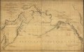
English: General map covering North Pacific Ocean, small part of Arctic Ocean north of Bering Strait, and the adjacent coastal regions of Russian Far East and Alaska. Printed map does not show specifically identified discoveries or explorers' routes. Relief shown pictorially. Title and place-names in old-orthography Russian; added notes in French. Facsim. reproductions (5 copies) of this map are separately cataloged under the class. no. G9236.S12 1802 .R8 1898; control no. 99-447844. Prime meridian: Ferro. Originally printed on 4 sheets (conjoined to form single sheet). Available also through the Library of Congress Web site as a raster image. LC copy mounted on paper backing and encapsulated. Includes handwritten notes in French describing specific later discoveries and latitude/longitude positions of place-names. |
||
| Title | Karta morskikh otkrytīĭ Rosīĭskimi moreplavateli︠a︡mi na Tikhom i Ledovitom mori︠a︡kh : v raznykh godakh uchinennykh | ||
| Shelf ID | G9236.S12 1802 .R8 | ||
| Date | |||
| Source | https://www.loc.gov/item/2009575229/ | ||
| Author | Russia. Depo Kart; Wilbrecht, Alexander | ||
| Permission (Reusing this file) |
|
||
| Other versions |
|
||
| Location | Alaska · United States · Arctic Ocean · North Pacific Ocean · Russian Federation · Russia (Federation) · Russian Far East | ||
| Part of | American Memory · General Maps · Catalog · Geography And Map Division | ||
| Subject | Coasts · Alaska · United States · Maps · Arctic Ocean · North Pacific Ocean · Russia (Federation) · Russian Far East · Discovery And Exploration |

Licensing[edit]
|
This is a faithful photographic reproduction of a two-dimensional, public domain work of art. The work of art itself is in the public domain for the following reason:
The official position taken by the Wikimedia Foundation is that "faithful reproductions of two-dimensional public domain works of art are public domain".
This photographic reproduction is therefore also considered to be in the public domain in the United States. In other jurisdictions, re-use of this content may be restricted; see Reuse of PD-Art photographs for details. | ||||
File history
Click on a date/time to view the file as it appeared at that time.
| Date/Time | Thumbnail | Dimensions | User | Comment | |
|---|---|---|---|---|---|
| current | 13:33, 22 May 2018 | | 14,661 × 9,235 (16.73 MB) | Fæ (talk | contribs) | LOC Maps https://www.loc.gov/item/2009575229/ #13324 |
You cannot overwrite this file.
File usage on Commons
The following 2 pages use this file: