File:Karst peaks with sea of clouds at sunrise, South view from the top of Mount Nam Xay, Vang Vieng, Laos.jpg
Jump to navigation
Jump to search
Size of this preview: 800 × 533 pixels. Other resolutions: 320 × 213 pixels | 640 × 427 pixels | 1,024 × 683 pixels | 1,280 × 853 pixels | 2,560 × 1,707 pixels | 6,129 × 4,086 pixels.
Original file (6,129 × 4,086 pixels, file size: 6.4 MB, MIME type: image/jpeg)
Captions
Captions
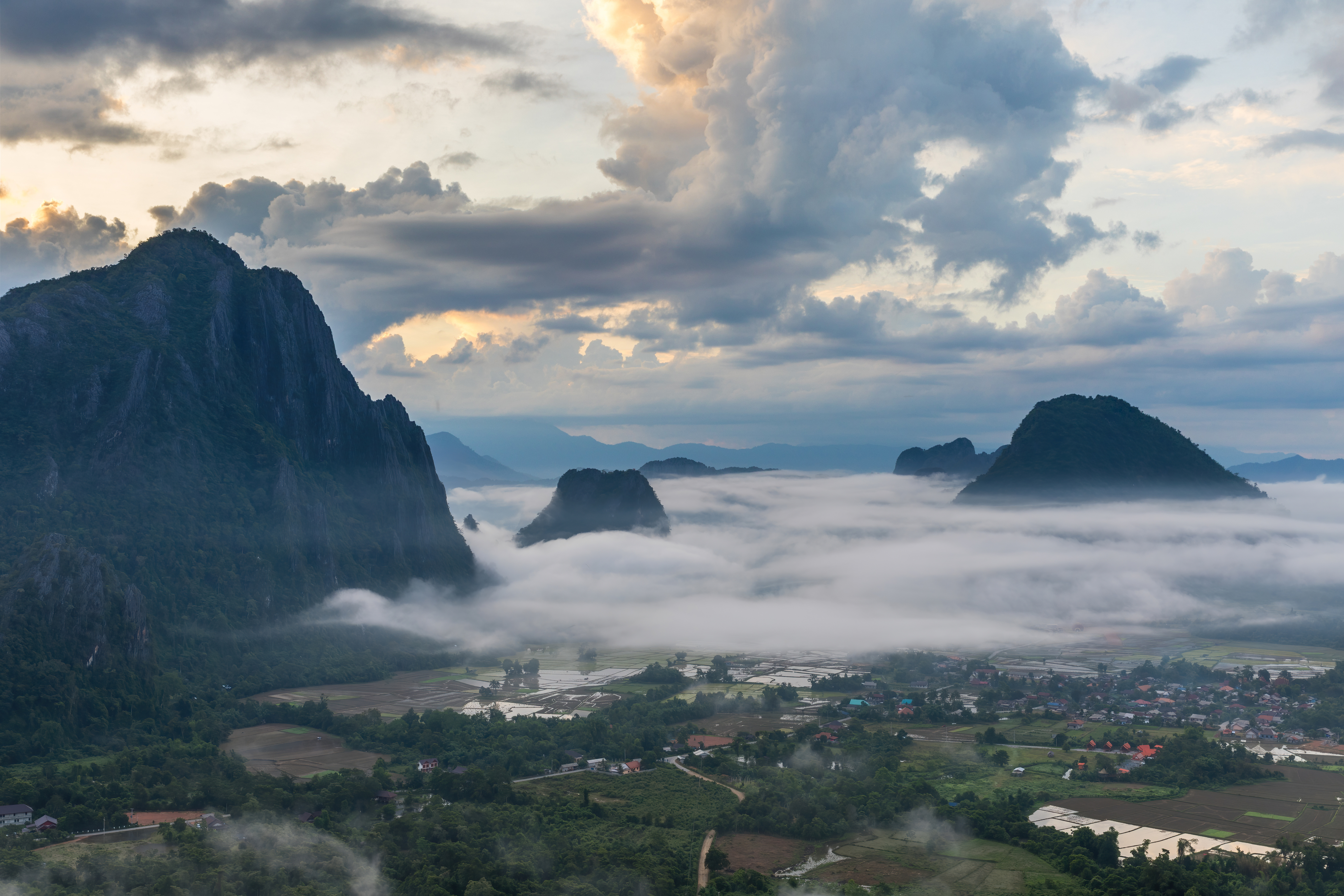
Karst peaks with sea of clouds at sunrise, South view from the top of Mount Nam Xay, Vang Vieng, Laos
Summary[edit]
| Description |
English: Karst peaks with colorful clouds above and sea of clouds below, covering the rice fields, at sunrise, South view from the top of Mount Nam Xay, during the monsoon, in Vang Vieng, Vientiane Province, Laos.
Français : Pitons karstiques au lever du soleil, avec des nuages colorés au-dessus et une mer de nuages au-dessous, recouvrant les rizières inondées, vue sud depuis le sommet du Mont Nam Xay, durant la mousson, à Vang Vieng, Province de Vientiane, Laos. |
| Date | |
| Source | Own work |
| Author | Basile Morin |
| Camera location | | View this and other nearby images on: OpenStreetMap |
|---|
|
Licensing[edit]
I, the copyright holder of this work, hereby publish it under the following license:
This file is licensed under the Creative Commons Attribution-Share Alike 4.0 International license.
- You are free:
- to share – to copy, distribute and transmit the work
- to remix – to adapt the work
- Under the following conditions:
- attribution – You must give appropriate credit, provide a link to the license, and indicate if changes were made. You may do so in any reasonable manner, but not in any way that suggests the licensor endorses you or your use.
- share alike – If you remix, transform, or build upon the material, you must distribute your contributions under the same or compatible license as the original.
File history
Click on a date/time to view the file as it appeared at that time.
| Date/Time | Thumbnail | Dimensions | User | Comment | |
|---|---|---|---|---|---|
| current | 00:12, 19 February 2021 | | 6,129 × 4,086 (6.4 MB) | Basile Morin (talk | contribs) | Minor improvement : blown highlights dialed down at the upper left corner |
| 09:30, 9 August 2020 |  | 6,129 × 4,086 (5.85 MB) | Basile Morin (talk | contribs) | Uploaded own work with UploadWizard |
You cannot overwrite this file.
File usage on Commons
The following 19 pages use this file:
- User:Derbeth/Various favs
- User:Dronebogus/Favorites
- User:Firefly/2020-B
- User:Meiræ/21
- User:Nardog/PotY
- User talk:Basile Morin/Archive 7 (2020)
- Commons:Featured picture candidates/File:Karst peaks with sea of clouds at sunrise, South view from the top of Mount Nam Xay, Vang Vieng, Laos.jpg
- Commons:Featured picture candidates/Log/December 2020
- Commons:Featured pictures/Natural phenomena
- Commons:Featured pictures/chronological/2020-B
- Commons:Featured pictures/chronological/December 2020
- Commons:Picture of the Year/2020/Candidates
- Commons:Picture of the Year/2020/R1/Gallery/2020-B
- Commons:Picture of the Year/2020/R1/Gallery/ALL
- Commons:Picture of the Year/2020/R1/Gallery/M12
- Commons:Picture of the Year/2020/R1/Gallery/Settlements
- Commons:Picture of the Year/2020/R1/v/Karst peaks with sea of clouds at sunrise, South view from the top of Mount Nam Xay, Vang Vieng, Laos.jpg
- Commons:Quality images/Subject/Sunsets
- Commons:Quality images candidates/Archives August 12 2020
File usage on other wikis
The following other wikis use this file:
- Usage on bcl.wiktionary.org
- Usage on bn.wikibooks.org
- Usage on de.wikipedia.org
- Usage on en.wikipedia.org
- Vang Vieng
- Wikipedia:Featured pictures/Places/Urban
- Talk:Vang Vieng
- User talk:Basile Morin
- User:Basile Morin
- Wikipedia:Featured picture candidates/February-2021
- Wikipedia:Featured picture candidates/Karst peaks with sea of clouds at sunrise, Vang Vieng, Laos
- Wikipedia:Featured pictures thumbs/70
- Wikipedia:Picture of the day/November 2023
- Template:POTD/2023-11-16
- User talk:TheFreeWorld/Archive 1
- Usage on fa.wikibooks.org
- Usage on fr.wikipedia.org
- Usage on hy.wikibooks.org
- Usage on lb.wikipedia.org
- Usage on uk.wikipedia.org
- Usage on www.wikidata.org
- Usage on zh.wikipedia.org