File:Karakalpakstan districts numbered.png
Jump to navigation
Jump to search

Size of this preview: 776 × 600 pixels. Other resolutions: 311 × 240 pixels | 621 × 480 pixels | 994 × 768 pixels | 1,280 × 989 pixels | 2,112 × 1,632 pixels.
Original file (2,112 × 1,632 pixels, file size: 58 KB, MIME type: image/png)
Captions
Captions
Add a one-line explanation of what this file represents
| Description |
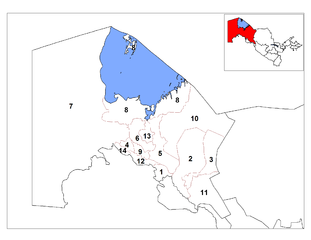
English: Map of the districts (tuman) of the Republic of Karakalpakstan in Uzbekistan.
Українська: Карта Каракалпакстану з номерами районів: 1. Амудар'їнський, 2. Берунійський, 3. Елліккалинський, 4. Канликульський, 5. Караузяцький, 6. Кегейлійський, 7. Кунградський, 8. Муйнацький, 9. Нукуський, 10. Тахтакупирський, 11. Турткульський, 12. Ходжейлійський, 13. Чимбайський, 14. Шуманайський. |
| Date | |
| Source | |
| Author |
|
| This is a retouched picture, which means that it has been digitally altered from its original version. Modifications: Change numbers, removed Bo’zotov District. The original can be viewed here: Karakalpakstan districts.png:
|
This file is licensed under the Creative Commons Attribution-Share Alike Attribution-Share Alike 4.0 International, 3.0 Unported, 2.5 Generic, 2.0 Generic and 1.0 Generic license.
- You are free:
- to share – to copy, distribute and transmit the work
- to remix – to adapt the work
- Under the following conditions:
- attribution – You must give appropriate credit, provide a link to the license, and indicate if changes were made. You may do so in any reasonable manner, but not in any way that suggests the licensor endorses you or your use.
- share alike – If you remix, transform, or build upon the material, you must distribute your contributions under the same or compatible license as the original.
Original upload log
[edit]
This image is a derivative work of the following images:
- File:Karakalpakstan_districts.png licensed with PD-self, PD-self/uk
- 2008-10-20T16:41:56Z Rarelibra 2112x1632 (55847 Bytes) bigger numbers [[Category:Maps of Uzbekistan]] [[Category:Districts of Uzbekistan]]
- 2008-10-20T15:35:02Z Rarelibra 2112x1632 (54053 Bytes) {{Information |Description={{en|1=Map of the districts (tuman) of the province (viloyat) of Karakalpakstan in Uzbekistan.}} |Source=Own work by uploader |Author=[[User:Rarelibra|Rarelibra]] |Date=10/20/2008 |Permission= |othe
Uploaded with derivativeFX
File history
Click on a date/time to view the file as it appeared at that time.
| Date/Time | Thumbnail | Dimensions | User | Comment | |
|---|---|---|---|---|---|
| current | 11:59, 11 February 2009 | | 2,112 × 1,632 (58 KB) | Ahonc (talk | contribs) | Vozrozhdeniya Island is also Mo’ynoq District (8) |
| 21:32, 30 January 2009 |  | 2,112 × 1,632 (57 KB) | Ahonc (talk | contribs) | {{Information |Description={{en|1=Map of the districts (tuman) of the Republic of Karakalpakstan in Uzbekistan.}} {{Uk|Карта Каракалпакстану з номерами районів:<br>1. Амудар'їнський, 2. Берунійськ |
You cannot overwrite this file.
File usage on Commons
There are no pages that use this file.
File usage on other wikis
The following other wikis use this file:
- Usage on uk.wikipedia.org