File:Kaart oefenterrein Vlakte van Waalsdorp.png
Jump to navigation
Jump to search

Size of this preview: 486 × 599 pixels. Other resolutions: 195 × 240 pixels | 389 × 480 pixels | 623 × 768 pixels | 830 × 1,024 pixels | 1,772 × 2,185 pixels.
Original file (1,772 × 2,185 pixels, file size: 4.81 MB, MIME type: image/png)
Captions
Captions
Add a one-line explanation of what this file represents
Summary
[edit]
| Description |
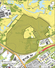
Nederlands: Kaart militair terrein – militair terrein – oefenterrein Vlakte van Waalsdorp uit de Regeling van de Minister van Infrastructuur en Milieu, van 13 juni 2016, nr. IENM/BSK-2016/86680, tot wijziging van de Regeling algemene regels ruimtelijke ordening (periodieke actualisatie en herstel van enkele gebreken). De begrenzing van het oefenterrein Vlakte van Waalsdorp is gewijzigd als gevolg van een gedeeltelijke afstoting en van een uitbreiding van een naastgelegen bedrijf waardoor de ontsluitingsweg gedeeltelijk is verlegd. |
| Date | |
| Source | https://zoek.officielebekendmakingen.nl/stcrt-2016-29608.html |
| Author | Staatscourant |
Licensing
[edit]
| This file is in the public domain because, according to the Dutch Copyright Act, no copyright subsists in laws, decrees or ordinances issued by public authorities, or in judicial or administrative decisions (Art. 11 Auteurswet).
To uploader: Please provide the date of first publication and the document source.
|
 |
File history
Click on a date/time to view the file as it appeared at that time.
| Date/Time | Thumbnail | Dimensions | User | Comment | |
|---|---|---|---|---|---|
| current | 19:59, 5 September 2021 | | 1,772 × 2,185 (4.81 MB) | Hannolans (talk | contribs) | Uploaded a work by Staatscourant from https://zoek.officielebekendmakingen.nl/stcrt-2016-29608.html with UploadWizard |
You cannot overwrite this file.
File usage on Commons
There are no pages that use this file.
File usage on other wikis
The following other wikis use this file:
- Usage on nl.wikipedia.org