File:KATW Destinations.gif
Jump to navigation
Jump to search
No higher resolution available.
KATW_Destinations.gif (720 × 360 pixels, file size: 20 KB, MIME type: image/gif)
Captions
Captions
Add a one-line explanation of what this file represents
Summary
[edit]
| Description |
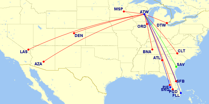
English: Map of current routes from Appleton International Airport (KATW) |
| Date | |
| Source | http://www.gcmap.com/mapui?P=ATW-ORD/CLT/DTW/ATL/MSP/LAS/PIE/AZA/SFB/DEN/PGD/BNA,c:green,ATW-SAV,c:blue,ATW-SRQ/FLL&MS=wls2&DU=mi |
| Author | Great Circle Mapper |
Licensing
[edit]
http://www.gcmap.com/faq/using#wikipedia

|
The copyright holder of this file allows anyone to use it for any purpose, provided that the copyright holder is properly attributed. Redistribution, derivative work, commercial use, and all other use is permitted. |
|
|
File history
Click on a date/time to view the file as it appeared at that time.
| Date/Time | Thumbnail | Dimensions | User | Comment | |
|---|---|---|---|---|---|
| current | 14:31, 26 December 2021 | | 720 × 360 (20 KB) | KDTW Flyer (talk | contribs) | Update data as of December 2021 |
| 18:48, 22 August 2020 |  | 720 × 360 (19 KB) | KDTW Flyer (talk | contribs) | Update Map | |
| 13:03, 29 January 2019 |  | 720 × 360 (18 KB) | KDTW Flyer (talk | contribs) | Update for new DEN and PDG services | |
| 00:42, 26 April 2017 |  | 720 × 360 (15 KB) | KDTW Flyer (talk | contribs) | {{Information |Description ={{en|1={{en|1=Map of current and future passenger routes from Appleton International Airport (KATW)}}}} |Source =http://www.gcmap.com/mapui?P=ATW-ORD,ATW-DTW,ATW-ATL,ATW-MSP,ATW-LAS,ATW-PIE,ATW-AZA,ATW-SFB&MS=wls2... |
You cannot overwrite this file.
File usage on Commons
The following 6 pages use this file:
- User:Chumwa/OgreBot/Potential transport maps/2019 January 21-31
- User:Chumwa/OgreBot/Transport Maps/2019 January 21-31
- User:Chumwa/OgreBot/Transport Maps/2020 August 21-31
- User:Chumwa/OgreBot/Transport Maps/2021 December 21-31
- User:Chumwa/OgreBot/Travel and communication maps/2019 January 21-31
- Commons:WikiProject Aviation/recent uploads/2019 January 29