File:Johnson’s Turkey in Asia, Persia, Arabia, etc. WDL11747.png
Jump to navigation
Jump to search

Size of this preview: 777 × 600 pixels. Other resolutions: 311 × 240 pixels | 622 × 480 pixels | 995 × 768 pixels | 1,280 × 988 pixels | 1,327 × 1,024 pixels.
Original file (1,327 × 1,024 pixels, file size: 2.62 MB, MIME type: image/png)
Captions
Captions
Add a one-line explanation of what this file represents
Summary
[edit]
| Author |
Русский: Джонсон, Э. Дж. (Элвин Джуитт), 1827–1884 гг.
Français : Colton, J. H. (Joseph Hutchins), 1800-1893
English: Colton, J. H. (Joseph Hutchins), 1800-1893
中文:A. J. (阿尔文·朱厄特)·约翰逊,1827 - 1884 年
Português: Colton, J. H. (Joseph Hutchins), 1800 a 1893
العربية: جونسون، أ. ج. (ألفين جيويت)، 1827-1884
Español: Colton, J. H. (Joseph Hutchins), 1800-1893 |
| Title |
Русский: Азиатская часть Турции, Персия, Аравия и т. д. в атласе Джонсона
Français : La Turquie asiatique, la Perse, l'Arabie, etc. de Johnson
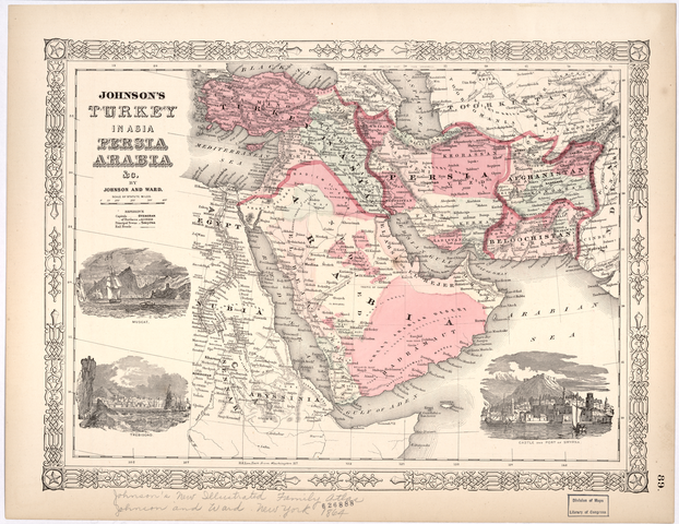
English: Johnson’s Turkey in Asia, Persia, Arabia, etc.
中文:《约翰逊的亚洲土耳其、波斯,阿拉伯和其他》
Português: Turquia asiática, Pérsia, Arábia etc. de Johnson
العربية: خريطة جونسون لتركيا الآسيوية وبلاد فارس وشبه الجزيرة العربية، إلخ.
Español: Turquía en Asia, Persia, Arabia, etcétera, de Johnson |
| Description |
Русский: Эта карта Среднего Востока, Центральной и Южной Азии, охватывающая территории от долины Нила до границы Афганистана с Британской Индией, входит в "Новый иллюстрированный семейный атлас Джонсона", изданный в Нью-Йорке в 1864 г. На карте указаны столицы государств, провинций, основные города и железные дороги. Суэцкий канал, который в то время еще только строился, помечен как предполагаемый объект. На карте обозначено множество больших и малых городов, расположенных вдоль реки Нил в Египте, Нубии (территория современного Южного Египта и Северного Судана) и Сеннаре (современный Судан), а также основные пороги. На иллюстрациях изображены портовые города Мускат в Омане и Требизонд и Смирна в Турции. Как и многие другие карты в "Новом иллюстрированном семейном атласе Джонсона", эта карта первоначально была издана нью-йоркской фирмой "J.H. Colton & Company". Ее отличает декоративное обрамление, характерное для большинства карт Колтона.
Аравийский залив; Аравийский полуостров; Персидский залив Français : Cette carte du Moyen-Orient et de l'Asie centrale et du Sud est extraite du Nouvel atlas familial illustré de Johnson publié à New York en 1864. Elle comprend les territoires s'étendant de la vallée du Nil à la frontière entre l'Afghanistan et l'Inde britannique. Elle indique les capitales nationales et provinciales, les villes principales et les lignes de chemin de fer. Le canal de Suez, en construction à l'époque, est indiqué tel qu'il fut proposé. La carte procure un aperçu détaillé des villes et des villages situés le long du Nil en Égypte, de la Nubie (aujourd'hui région du sud de l'Égypte et du nord du Soudan), du Sennar (Soudan actuel) et des principales cataractes du fleuve. Elle contient des illustrations des villes portuaires de Mascate, dans le Sultanat d'Oman ainsi que de Trébizonde et Smyrne, en Turquie. Comme de nombreuses cartes parues dans le Nouvel atlas familial illustré de Johnson, la carte présentée ici fut à l'origine produite par l'entreprise new-yorkaise J.H. Colton & Company dont elle présente la bordure décorative distinctive, une caractéristique que l'on retrouve sur la plupart des cartes de Colton.
Golfe Arabique; Péninsule arabique; Golfe Persique English: This map of the Middle East and Central and South Asia extending from the Nile Valley to the boundary of Afghanistan with British India is from Johnson’s New Illustrated Family Atlas, published in New York in 1864. The map shows national capitals, provincial capitals, principal towns, and railroads. The Suez Canal, under construction at this time, is shown as proposed. The map provides a detailed overview of the towns and cities along the Nile in Egypt, Nubia (present-day southern Egypt and northern Sudan), and Sennar (present-day Sudan), and of the river’s major cataracts. Illustrations depict the port cities of Muscat in Oman and Trebizond and Smyrna in Turkey. Like many of the maps in Johnson’s New Illustrated Family Atlas, this map originally was produced by J.H. Colton & Company of New York and displays the distinctive decorative border characteristic of most Colton maps.
Arabian Gulf; Arabian Peninsula; Persian Gulf 中文:这张中东、中亚和南亚地图载于 1864 年在纽约出版的 Johnson’s New Illustrated Family Atlas(《约翰逊全新图解系列地图集》),其西端起于尼罗河河谷,东端止于阿富汗和英属印度的边界线。在地图上可以看到国家首都、省会、主要城镇和铁路。当时正在开凿的苏伊士运河,在地图上作为拟建运河标识。地图还显示了埃及、努比亚(今埃及南部和苏丹北部)和森纳尔(今苏丹)境内尼罗河沿岸的城镇和城市以及尼罗河主要急流的详细概况。图示则描绘了阿曼的港口城市马斯喀特以及土耳其的特拉布宗和士麦那。与《约翰逊全新图解系列地图集》中的许多地图一样,这张地图原由纽约 J·H·科尔顿公司 (J.H. Colton & Company of New York) 绘制,也有多数科尔顿公司地图中极富特色的装饰性花边。
阿拉伯湾; 阿拉伯半岛; 波斯湾 Português: Este mapa do Oriente Médio e da Ásia Central e Meridional, que vai do Vale do Nilo até a fronteira do Afeganistão com a Índia Britânica, é do Novo Atlas Familiar Ilustrado de Johnson, publicado em Nova York em 1864. O mapa mostra capitais nacionais, capitais provinciais, principais vilas e ferrovias. O Canal de Suez, sob construção naquele momento, é exibido conforme proposto. O mapa fornece uma visão geral detalhada das vilas e cidades ao longo do Nilo, no Egito, na Núbia (atual sul do Egito e norte do Sudão), no Sennar (atual Sudão) e das principais cataratas do rio. As ilustrações representam as cidades portuárias de Muscate, no Omã, e de Trebizond e Smyrna, na Turquia. Como muitos dos mapas no Novo Atlas Familiar Ilustrado de Johnson, este mapa foi produzido originalmente pela J.H. Colton & Company, de Nova York, e exibe as típicas bordas decorativas que caracterizam a maioria dos mapas de Colton.
Golfo Arábico; Península Arábica; Golfo Pérsico العربية: تُوجد هذه الخريطة للشرق الأوسط ووسط وجنوب آسيا الممتدة من وادي النيل وحتى حدود أَفْغَانِسْتَان مع الهند البريطانية، ضمن أطلس جونسون العائلي المصور الجديد الذي نُشر بنيويورك في عام 1864. وتُظهر الخريطة العواصم القومية والعواصم الإقليمية والمدن الرئيسية والسكك الحديدية. تظهر قناة السويس، التي كانت تحت الإنشاء في ذلك الوقت، على أنها مُقترَحة. تعرض الخريطة لمحة عامة مفصلة عن المدن والبلدات على امتداد نهر النيل بمصر والنوبة (جنوب مصر وشمال السودان الحالية) وسنار (السودان الحالية) وعن شلالات النهر الرئيسية. تُصور الرسوم التوضيحية المدن الساحلية المتمثلة في مسقط بعمان وطرابزون وسميرنا بتركيا. أعدت مؤسسة ج. هـ. كولتون وشركاه بنيويورك هذه الخريطة في الأصل، شأنها في ذلك شأن العديد من الخرائط في أطلس جونسون العائلي المصور الجديد، ويَظهر حولها الإطار المزخرف الذي يُميز معظم خرائط كولتون.
الخليج العربي; شبه الجزيرة العربية; الخليج الفارسي Español: Este mapa de Oriente Medio y Asia Meridional y Asia Central, que abarca desde el valle del Nilo hasta la frontera de Afganistán con la India británica pertenece al Nuevo altas familiar ilustrado de Johnson, publicado en Nueva York en 1864. El mapa muestra las capitales nacionales, las capitales de provincia, las ciudades importantes y los ferrocarriles. Se muestra el proyecto del canal de Suez, que en ese entonces estaba en construcción. El mapa ofrece una visión detallada de las principales cataratas del Nilo y de los pueblos y las ciudades a lo largo de este río, pasando por Egipto, Nubia (actual sur de Egipto y norte de Sudán) y Sennar (actual Sudán). Las ilustraciones representan los puertos de Mascate, en Omán, y de Trebisonda y de Esmirna, en Turquía. Como muchos de los mapas en Nuevo altas familiar ilustrado de Johnson, este fue producido originalmente por J. H. Colton & Company de Nueva York y muestra el borde decorativo distintivo y característico de la mayoría de los mapas de Colton.
Golfo Arábigo; Península de Arabia; Golfo Pérsico |
| Date | 1864 |
| Medium |
Русский: Карты
Français : Cartes
English: Maps
中文:地图
Português: Mapas
العربية: خرائط
Español: Mapas |
| Dimensions |
English: 1 map : color ; 27 x 38 centimeters |
| Collection |
Русский: Библиотека Конгресса
Français : Bibliothèque du Congrès
English: Library of Congress
中文:国会图书馆
Português: Biblioteca do Congresso
العربية: مكتبة الكونغرس
Español: Biblioteca del Congreso |
| Place of creation |
Русский: Эритрея
Français : Erythrée
English: Eritrea
中文:厄立特里亚
Português: Eritreia
العربية: إريتريا
Español: Eritrea |
| Notes |
Original language title: Johnson's Turkey in Asia: Persia Arabia &c. Русский: Примерный масштаб 1:15 000 000
Français : Échelle : 1:15 000 000 env.
English: Scale approximately 1:15,000,000
中文:比例尺约为 1:15,000,000
Português: Escala de aproximadamente 1:15.000.000
العربية: مقياس الرسم بالتقريب 1:15,000,000
Español: Escala aproximada: 1:15 000 000 |
| References | http://hdl.loc.gov/loc.wdl/dlc.11747 |
| Source/Photographer |
|
Licensing
[edit]
|
This is a faithful photographic reproduction of a two-dimensional, public domain work of art. The work of art itself is in the public domain for the following reason:
The official position taken by the Wikimedia Foundation is that "faithful reproductions of two-dimensional public domain works of art are public domain".
This photographic reproduction is therefore also considered to be in the public domain in the United States. In other jurisdictions, re-use of this content may be restricted; see Reuse of PD-Art photographs for details. | ||||
File history
Click on a date/time to view the file as it appeared at that time.
| Date/Time | Thumbnail | Dimensions | User | Comment | |
|---|---|---|---|---|---|
| current | 23:34, 10 March 2014 | | 1,327 × 1,024 (2.62 MB) | Fæ (talk | contribs) | =={{int:filedesc}}== {{Artwork |artist = |author ={{ru|1=Джонсон, Э. Дж. (Элвин Джуитт), 1827–1884 гг.}} {{fr|1=Colton, J. H. (Joseph Hutchins), 1800-1893}} {{en|1=Colton, J. H. (Joseph Hutchins), 1800-1893}} {{zh|1=A. J. (�... |
You cannot overwrite this file.
File usage on Commons
The following page uses this file: