File:Joh. Bapt. Homann - Geographische Vorstellung der jämerlichen Wasser-Flutt in Nieder-Teutschland.jpg
Original file (6,920 × 5,840 pixels, file size: 16.03 MB, MIME type: image/jpeg)
Captions
Captions
Summary
[edit]| Description |
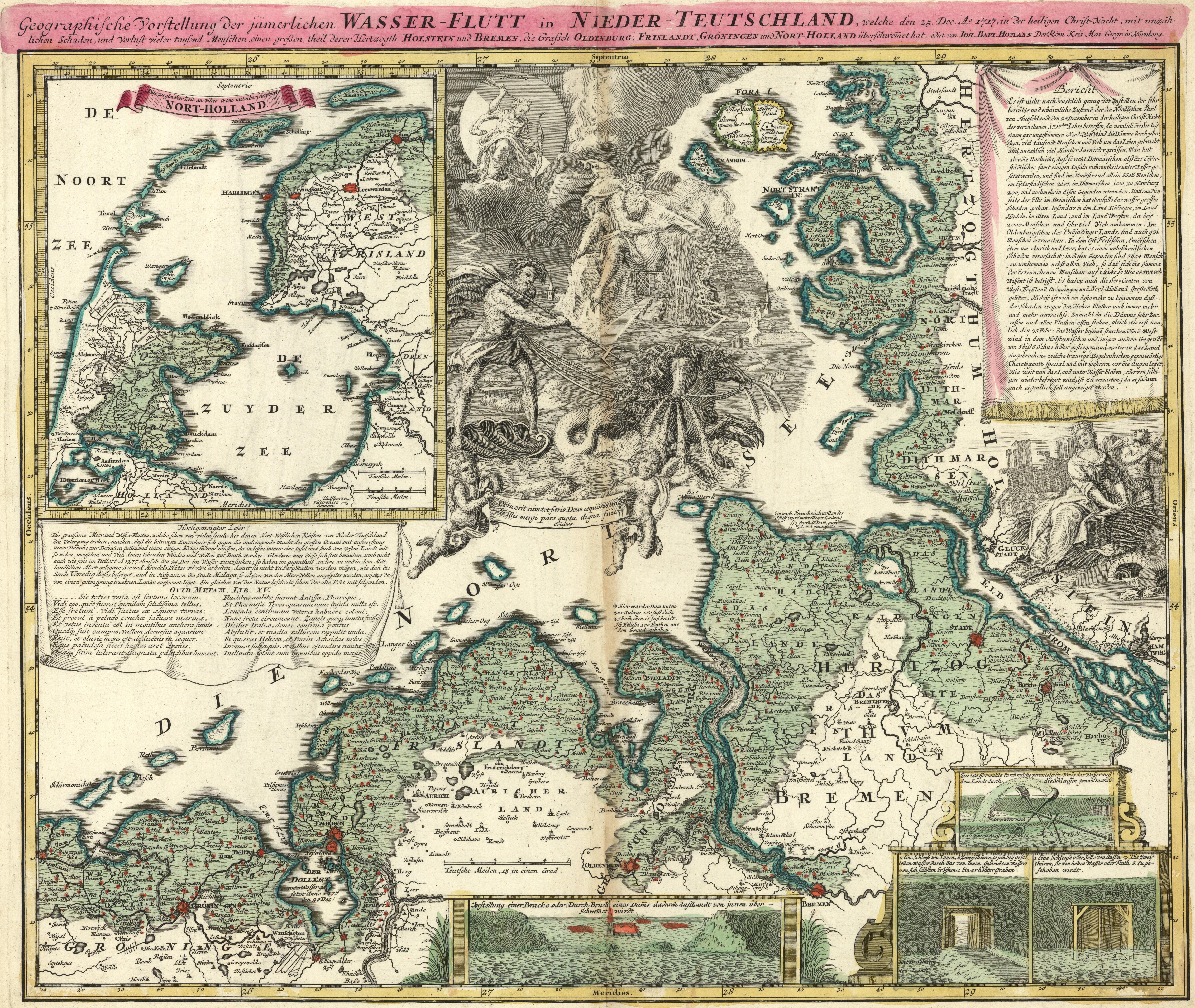
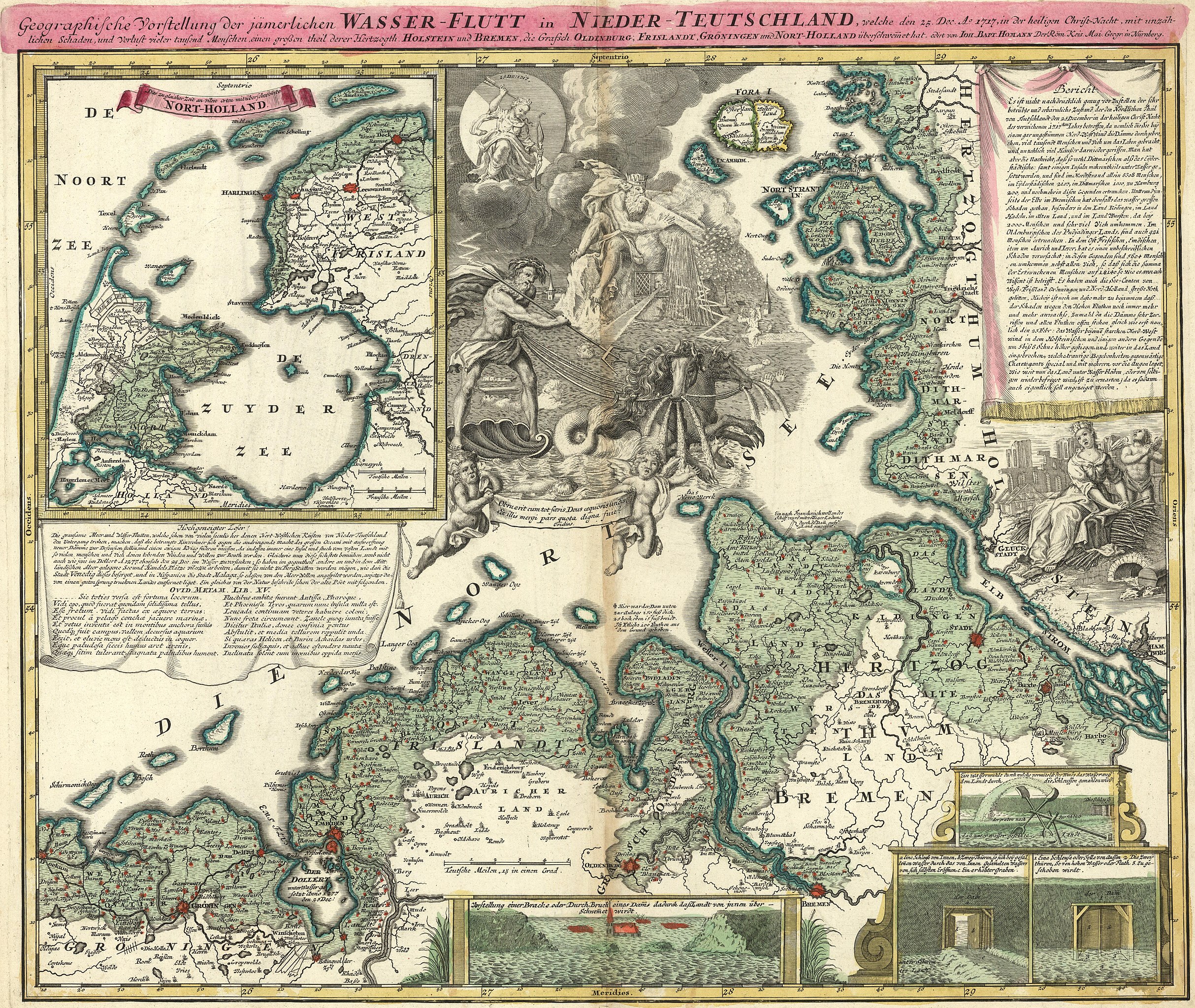
Nederlands: Kaart van Johann Baptist Homann uit 1720 van de Kerstvloed in een poging om de grenzen van de overstroomde gebieden weer te geven: De volledige titel luidt: Geographische Vorstellung der jämmerlichen WASSER-FLUTT in NIEDERTEUTSCHLAND, welche den 25.Dec. Ao. 1717, in der heiligen Christ-Nacht, mit unzählichen Schaden und Verlust vieler tausend Menschen einen großen theil derer Hertzogth. HOLSTEIN und BREMEN, die Grafsch. OLDENBURG, FRISLANDT, GRÖNINGEN und NORT-HOLLAND überschwemmet hat.
Vertaling: Geografische voorstelling van de jammerlijke watervloed in Neder-Duitsland, die op 25 december 1717, tijdens Kerstnacht, met ontzagwekkende schade en verlies van vele duizenden mensenlevens een groot deel van het Hertogdom Holstein en Bremen, het Graafschap Oldenburg, Friesland, Groningen en Noord-Holland heeft overstroomd. De kaart geeft een globaal beeld. Lang niet alle grenzen klopten precies met de werkelijkheid. |
|||||||||||||||||||||||
| Date | ||||||||||||||||||||||||
| Source | Beeldbank Groningen | |||||||||||||||||||||||
| Author |
|
|||||||||||||||||||||||
| Other versions |
|
|||||||||||||||||||||||
.jpg)


Licensing
[edit]
|
This work is in the public domain in its country of origin and other countries and areas where the copyright term is the author's life plus 70 years or fewer. This work is in the public domain in the United States because it was published (or registered with the U.S. Copyright Office) before January 1, 1929. | |
| This file has been identified as being free of known restrictions under copyright law, including all related and neighboring rights. | |
File history
Click on a date/time to view the file as it appeared at that time.
| Date/Time | Thumbnail | Dimensions | User | Comment | |
|---|---|---|---|---|---|
| current | 16:30, 22 December 2017 | | 6,920 × 5,840 (16.03 MB) | Hardscarf (talk | contribs) | User created page with UploadWizard |
You cannot overwrite this file.
File usage on Commons
The following 5 pages use this file:
File usage on other wikis
The following other wikis use this file:
- Usage on de.wikipedia.org
- Usage on en.wikipedia.org
- Usage on nds.wikipedia.org
- Usage on nl.wikipedia.org
- Usage on www.wikidata.org
Metadata
- Christmas flood 1717
- Old weather and climate maps
- 1720 maps
- Maps of weather in 1717
- Maps of floods
- Maps of weather and climate of Denmark
- 1720s maps of Denmark
- Old maps of Lower Saxony
- Lower Saxony in the 1710s
- Old maps of Schleswig-Holstein
- 1720s maps of Germany
- 1720s maps of the Netherlands
- Maps of weather events in the Netherlands
- Hydrographic maps of the Netherlands
- Maps of the Dollard