File:Java Locator Topography.png
Jump to navigation
Jump to search

Size of this preview: 800 × 515 pixels. Other resolutions: 320 × 206 pixels | 640 × 412 pixels | 1,024 × 660 pixels | 1,280 × 825 pixels | 2,525 × 1,627 pixels.
Original file (2,525 × 1,627 pixels, file size: 1.36 MB, MIME type: image/png)
Captions
Captions
Add a one-line explanation of what this file represents
Summary[edit]
| Description |
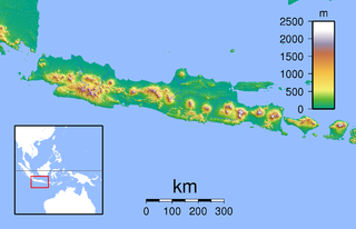
Topographic location map of Java (Indonesia). Created with GMT from SRTM data Left: 104.5, Right: 117.0, Bottom: -12.0666667 Top: -4.0. For non-locator version, see Image:Java Topography.png |
| Date | |
| Source | Own work |
| Author | Sadalmelik |
Licensing[edit]
| I, the copyright holder of this work, release this work into the public domain. This applies worldwide. In some countries this may not be legally possible; if so: I grant anyone the right to use this work for any purpose, without any conditions, unless such conditions are required by law. |
File history
Click on a date/time to view the file as it appeared at that time.
| Date/Time | Thumbnail | Dimensions | User | Comment | |
|---|---|---|---|---|---|
| current | 22:24, 8 June 2010 | | 2,525 × 1,627 (1.36 MB) | Ras67 (talk | contribs) | cropped |
| 18:13, 30 August 2007 |  | 2,546 × 1,644 (1.37 MB) | Sadalmelik (talk | contribs) | {{Information |Description=Topographic location map of Java (Indonesia). Created with GMT from SRTM data Left: 104.5, Right: 117.0, Bottom: -12.0666667 Top: -4.0 |Source=self-made |Date=30 August, 2007 |Author= Sadalmelik }} [[Categor |
You cannot overwrite this file.
File usage on Commons
The following 2 pages use this file:
File usage on other wikis
The following other wikis use this file:
- Usage on an.wikipedia.org
- Usage on ar.wikipedia.org
- Usage on ceb.wikipedia.org
- Usage on cs.wikipedia.org
- Usage on en.wikipedia.org
- Usage on es.wikipedia.org
- Usage on fr.wikipedia.org
- Temple de Borobudur
- Merapi
- Bromo
- Caldeira Tengger
- Îles Karimunjawa
- Wilis
- Kamojang
- Mont Gede
- Mont Penanggungan
- Parc national d'Ujung Kulon
- Péninsule de Blambangan
- Semeru
- Merapi (Ijen)
- Kawah Ijen
- Guntur (Indonésie)
- Parc national de Meru Betiri
- Arjuno-Welirang
- Lawu
- Homme de Java
- Kelud
- Raung
- Plateau de Dieng
- Parc national de Bromo-Tengger-Semeru
- Butak
- Kawi (volcan)
- Argapura
- Parc national d'Alas Purwo
- Baluran
- Parc national de Baluran
- Segara Anakan
- Slamet
- Massacre de Rawagede
- Ciremai
- Parc national Halimun Salak
View more global usage of this file.