File:Japanese expansion april 1942.svg
Jump to navigation
Jump to search

Size of this PNG preview of this SVG file: 800 × 467 pixels. Other resolutions: 320 × 187 pixels | 640 × 374 pixels | 1,024 × 598 pixels | 1,280 × 747 pixels | 2,560 × 1,494 pixels | 1,064 × 621 pixels.
Original file (SVG file, nominally 1,064 × 621 pixels, file size: 460 KB)
Captions
Captions
Add a one-line explanation of what this file represents
Summary
[edit]| Description |
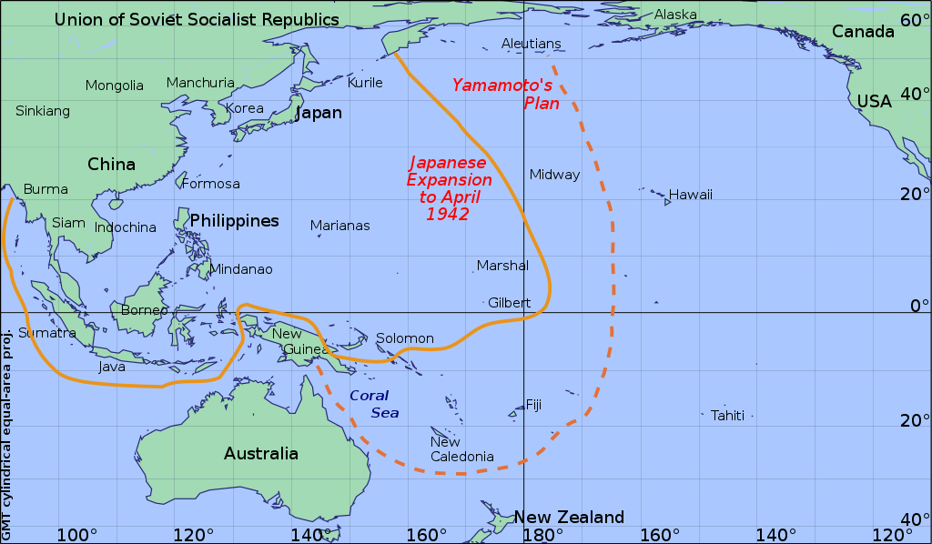
English: Japanese expansion April 1942. |
||||||||||
| Date | |||||||||||
| Source |
Own work using:
|
||||||||||
| Author | Createaccount | ||||||||||
| Permission (Reusing this file) |
|

Licensing
[edit]
I, the copyright holder of this work, hereby publish it under the following license:
| This file is made available under the Creative Commons CC0 1.0 Universal Public Domain Dedication. | |
| The person who associated a work with this deed has dedicated the work to the public domain by waiving all of their rights to the work worldwide under copyright law, including all related and neighboring rights, to the extent allowed by law. You can copy, modify, distribute and perform the work, even for commercial purposes, all without asking permission.
|
File history
Click on a date/time to view the file as it appeared at that time.
| Date/Time | Thumbnail | Dimensions | User | Comment | |
|---|---|---|---|---|---|
| current | 23:23, 9 October 2019 | | 1,064 × 621 (460 KB) | Amílcar (talk | contribs) | Reverted to version as of 13:38, 14 December 2016 (UTC) |
| 15:56, 28 August 2019 |  | 1,064 × 621 (441 KB) | Amílcar (talk | contribs) | File uploaded using svgtranslate tool (https://tools.wmflabs.org/svgtranslate/). Added translation for es. | |
| 13:38, 14 December 2016 |  | 1,064 × 621 (460 KB) | Bkell (talk | contribs) | fixed spellings in name of map projection | |
| 13:29, 11 July 2013 |  | 1,064 × 621 (460 KB) | Keysanger (talk | contribs) | User created page with UploadWizard |
You cannot overwrite this file.
File usage on Commons
The following 18 pages use this file:
- User:Chumwa/OgreBot/Potential transport maps/2016 December 11-20
- User:Chumwa/OgreBot/Potential transport maps/2019 August 21-31
- User:Chumwa/OgreBot/Potential transport maps/2019 October 1-10
- User:Chumwa/OgreBot/Transport Maps/2016 December 11-20
- User:Chumwa/OgreBot/Transport Maps/2019 August 21-31
- User:Chumwa/OgreBot/Transport Maps/2019 October 1-10
- User:Chumwa/OgreBot/Travel and communication maps/2016 December 11-20
- User:Chumwa/OgreBot/Travel and communication maps/2019 August 21-31
- User:Chumwa/OgreBot/Travel and communication maps/2019 October 1-10
- User:Holly Cheng/Recent uploads/Hawaii/2016 December 14
- User:Holly Cheng/Recent uploads/Hawaii/2019 August 28
- User:Holly Cheng/Recent uploads/Hawaii/2019 October 9
- User:Magog the Ogre/Maps of conflicts/2016 December
- User:Magog the Ogre/Maps of conflicts/2019 August
- User:Magog the Ogre/Maps of conflicts/2019 October
- Commons:WikiProject Aviation/recent uploads/2016 December 14
- Commons:WikiProject Aviation/recent uploads/2019 August 28
- Commons:WikiProject Aviation/recent uploads/2019 October 9
File usage on other wikis
The following other wikis use this file:
- Usage on azb.wikipedia.org
- Usage on cs.wikipedia.org
- Usage on en.wikipedia.org
- Usage on fy.wikipedia.org
- Usage on ka.wikipedia.org
- Usage on mk.wikipedia.org
- Usage on no.wikipedia.org
- Usage on pt.wikipedia.org
- Usage on simple.wikipedia.org
- Usage on sk.wikipedia.org
- Usage on ur.wikipedia.org