File:Japan (MODIS 2015-05-10).jpg

Original file (6,400 × 7,600 pixels, file size: 6.07 MB, MIME type: image/jpeg)
Captions
Captions
Summary
[edit].jpg&action=edit§ion=1)
| Description |
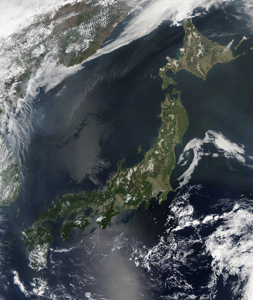
English: On May 2, 2015 the Moderate Resolution Imaging Spectroradiometer (MODIS) aboard NASA�s Aqua satellite flew over Japan and captured this true-color image of the region.
In this image, vegetation appears green, while tan represents non-vegetated land or early spring grassland that has not greened with new growth. The mottled white over parts of Japan are small clouds which have formed over higher elevations. To the north, a long cloud bank hides much of the Korean Peninsula and extends over China and parts of southeastern Russia. Smoke from fires burning in North Korea, eastern Russia and China hangs over the Sea of Japan. The Russian fires can be seen as a cluster of red hot-spots, while other fires are hidden under heavy cloud cover. Japan is an island nation made up of over 6,850 islands. The four largest islands make up about 97 percent of the land area of Japan, and are easily identified in this image. Hokkaido is the northern-most island, and appears roughly diamond-shaped. Just south of Hokkaido is Honshu � the largest and longest island. Shikoku lies just south of Honshu, and Kyushu is the most southerly of the large islands. Japan is a volcanic archipelago and is located at the junction of four shifting tectonic plates. With over 100 active volcanoes, Japan has approximately 10% of the world�s active volcanoes. The region is also seismically active, so earthquakes are common. In late April and early May, 2015, seismic activity increased, especially under the Owakudani hydrothermic field near the Hakone volcano. The intense earthquake swarms, along with slight deformation of the ground around the volcano, caused the Japan Meteorological Agency (JMA) to raise the alert for the Hakone volcano to level 2, and to close access to the popular tourist region near the volcano on May 7. |
||
| Date | Taken on 2 May 2015 | ||
| Source |
|
||
| Author | Jeff Schmaltz, MODIS Land Rapid Response Team, NASA GSFC |
| This media is a product of the Aqua mission Credit and attribution belongs to the mission team, if not already specified in the "author" row |
Licensing
[edit].jpg&action=edit§ion=2)
| This file is in the public domain in the United States because it was solely created by NASA. NASA copyright policy states that "NASA material is not protected by copyright unless noted". (See Template:PD-USGov, NASA copyright policy page or JPL Image Use Policy.) | ||
 |
Warnings:
|
File history
Click on a date/time to view the file as it appeared at that time.
| Date/Time | Thumbnail | Dimensions | User | Comment | |
|---|---|---|---|---|---|
| current | 21:39, 14 February 2024 | | 6,400 × 7,600 (6.07 MB) | OptimusPrimeBot (talk | contribs) | #Spacemedia - Upload of http://modis.gsfc.nasa.gov/gallery/images/image05102015_250m.jpg via Commons:Spacemedia |
You cannot overwrite this file.
File usage on Commons
There are no pages that use this file.
.jpg&oldid=851753865)