File:Japan’s Meiji Industrial Revolution sites map Hagi City center.svg
Jump to navigation
Jump to search

Size of this PNG preview of this SVG file: 533 × 600 pixels. Other resolutions: 213 × 240 pixels | 427 × 480 pixels | 683 × 768 pixels | 910 × 1,024 pixels | 1,820 × 2,048 pixels | 1,200 × 1,350 pixels.
Original file (SVG file, nominally 1,200 × 1,350 pixels, file size: 768 KB)
Captions
Captions
Add a one-line explanation of what this file represents
Summary[edit]
| Description |
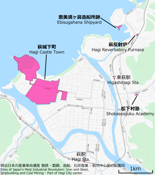
English: Map of Japan’s Meiji Industrial Revolution, World Heritage Sites in Hagi City center. |
|||
| Date | ||||
| Source | You may find a page on the OpenStreetMap wiki page for Hagi | |||
| Creator |
OpenStreetMap contributors, and Pekachu OpenStreetMap contributors |
|||
| Permission (Reusing this file) |
OpenStreetMap data is available under the Open Database License (details). Map tiles are licensed under the Creative Commons Attribution-ShareAlike 2.0 license (CC-BY-SA 2.0).
This file is licensed under the Creative Commons Attribution-Share Alike 2.0 Generic license.
|
|||
| Georeferencing | If inappropriate please set warp_status = skip to hide. |
File history
Click on a date/time to view the file as it appeared at that time.
| Date/Time | Thumbnail | Dimensions | User | Comment | |
|---|---|---|---|---|---|
| current | 12:17, 18 July 2015 | | 1,200 × 1,350 (768 KB) | Pekachu (talk | contribs) | フォント修正 |
| 10:27, 16 July 2015 |  | 1,200 × 1,350 (581 KB) | Pekachu (talk | contribs) | User created page with UploadWizard |
You cannot overwrite this file.
File usage on Commons
There are no pages that use this file.
File usage on other wikis
The following other wikis use this file:
- Usage on hr.wikipedia.org
- Usage on ja.wikipedia.org
- Usage on pl.wikipedia.org
- Usage on zh.wikipedia.org