File:Jabodebek LRT system map.jpg
Jump to navigation
Jump to search

Size of this preview: 800 × 600 pixels. Other resolutions: 320 × 240 pixels | 640 × 480 pixels | 1,024 × 768 pixels | 1,280 × 960 pixels | 2,560 × 1,920 pixels | 4,000 × 3,000 pixels.
Original file (4,000 × 3,000 pixels, file size: 2.93 MB, MIME type: image/jpeg)
Captions
Captions
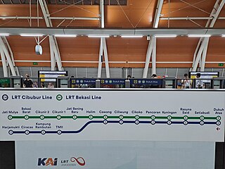
Jabodebek LRT system map taken at Dukuh Atas LRT Station platform 2's PSD
Summary[edit]
| Description |
English: Jabodebek LRT system map taken at Dukuh Atas LRT Station platform 2's PSD
Bahasa Indonesia: Foto peta rute jalur LRT Jabodebek diambil dari PSD peron 2 stasiun LRT Dukuh Atas |
| Date | |
| Source | Own work |
| Author | Tappyoca |
| Camera location | | View this and other nearby images on: OpenStreetMap |
|---|
Licensing[edit]
I, the copyright holder of this work, hereby publish it under the following license:
This file is licensed under the Creative Commons Attribution-Share Alike 4.0 International license.
- You are free:
- to share – to copy, distribute and transmit the work
- to remix – to adapt the work
- Under the following conditions:
- attribution – You must give appropriate credit, provide a link to the license, and indicate if changes were made. You may do so in any reasonable manner, but not in any way that suggests the licensor endorses you or your use.
- share alike – If you remix, transform, or build upon the material, you must distribute your contributions under the same or compatible license as the original.
File history
Click on a date/time to view the file as it appeared at that time.
| Date/Time | Thumbnail | Dimensions | User | Comment | |
|---|---|---|---|---|---|
| current | 16:15, 28 October 2023 | | 4,000 × 3,000 (2.93 MB) | Tappyoca (talk | contribs) | Uploaded own work with UploadWizard |
You cannot overwrite this file.
File usage on Commons
There are no pages that use this file.