File:J J Duffus Plaque Peterborough Ontario Canada (1).jpg

Original file (4,000 × 3,000 pixels, file size: 4.25 MB, MIME type: image/jpeg)
Captions
Captions
Summary
[edit].jpg&action=edit§ion=1)
| Description |
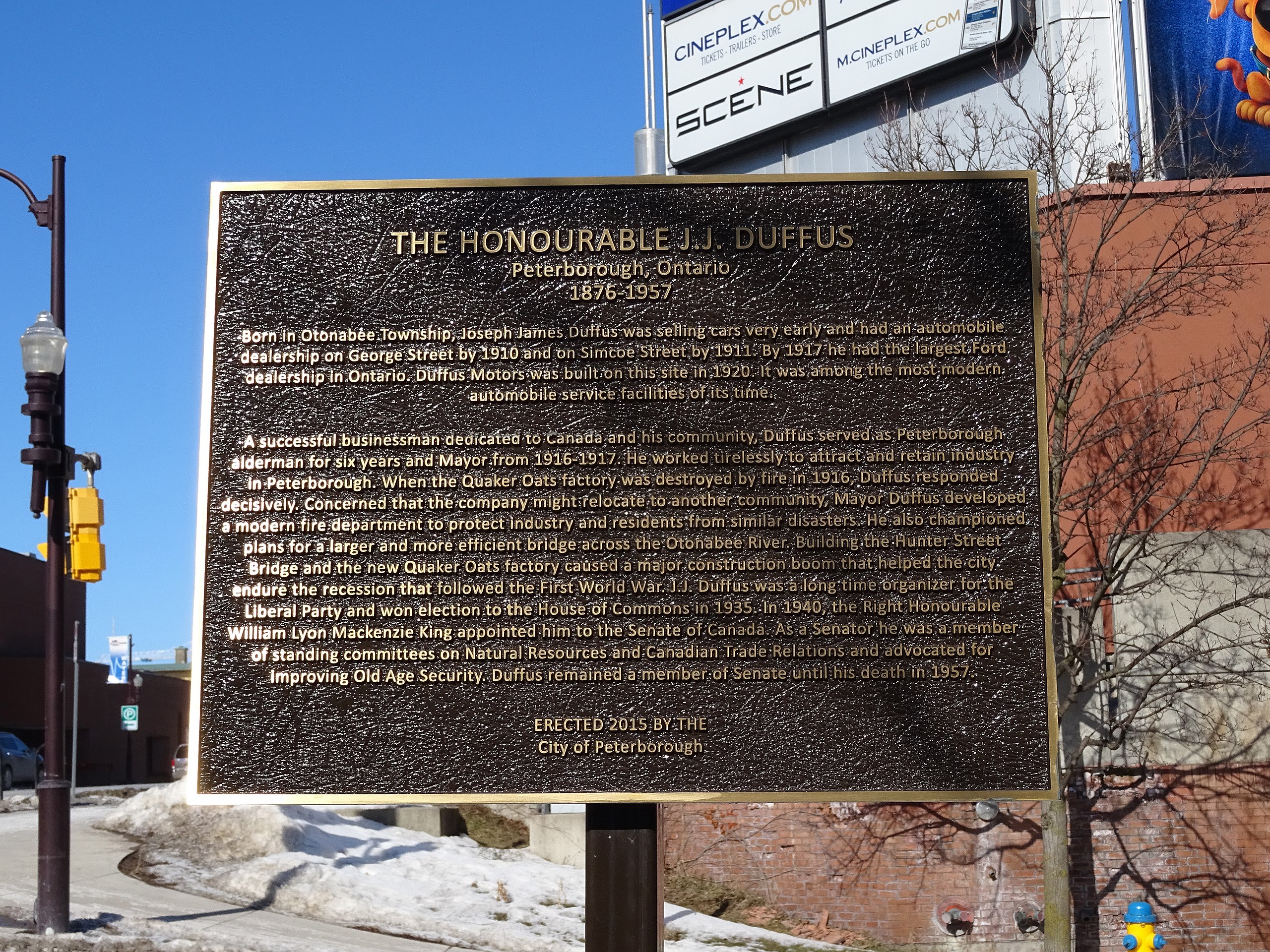
English: J J Duffus Plaque Peterborough Ontario Canada - Corner of Water St and Charlotte St, Peterborough, ON
"THE HONOURABLE J.J DUFFUS Peterborough, Ontario 1876-1957 Born in Otonabée Township, Joseph James, Duffus was selling cars very early and had an automobile, dealership on George Street by 1910 and on Simcoe Street by 1911. By 1917 he had the largest Ford Dealership in Ontario. Duffus Motors was built:on this site in 1925: 1t was among the most modern automobile service facilities of its time. A successful businessman dedicated to Canada and his community, Duffüs served as Peterborough alderman for six years and Mayor from 1916-1917. He worked tirelessly to attract and retain industry in Peterborough. When the Quaker Oats factory was destroyed by fire in 1916, Duffus responded decisively. Concerned that the company might relocate to another community, Mayor Duffus developed a modern fire department to protect industry and residents from similar disasters. He also championed plans for a larger and more efficient bridge across the Otonabee River. Building the Hunter Street Bridge and the new Quaker Oats factory, caused a major construction boom that helped the-city endure the recession that followed the First World War. J.J. Duffus was a long time organizer for the Liberal Party and won election to the House of Commons in 1935. In 1940, the Right Honourable William Lyon Mackenzie King appointed him to the Senate of Canada. As a Senator, he was a member of standing committees on Natural Resources and Canadian Trade Relations and advocated for improving Old Age Security. Duffus remained a member of Senate until his death in 1957" Erected by City of Peterborough on 15 October 2015 |
| Date | |
| Source | Own work |
| Author | Spudgun67 |
| Camera location | | View this and other nearby images on: OpenStreetMap |
|---|
.jpg¶ms=044.303320_N_-078.318713_E_globe:Earth_type:camera__&language=en)
Licensing
[edit].jpg&action=edit§ion=2)
- You are free:
- to share – to copy, distribute and transmit the work
- to remix – to adapt the work
- Under the following conditions:
- attribution – You must give appropriate credit, provide a link to the license, and indicate if changes were made. You may do so in any reasonable manner, but not in any way that suggests the licensor endorses you or your use.
- share alike – If you remix, transform, or build upon the material, you must distribute your contributions under the same or compatible license as the original.
File history
Click on a date/time to view the file as it appeared at that time.
| Date/Time | Thumbnail | Dimensions | User | Comment | |
|---|---|---|---|---|---|
| current | 15:07, 8 March 2020 | | 4,000 × 3,000 (4.25 MB) | Spudgun67 (talk | contribs) | Uploaded own work with UploadWizard |
You cannot overwrite this file.
File usage on Commons
There are no pages that use this file.
.jpg&oldid=598264293)