File:Istria County OpenStreetMap.svg
Jump to navigation
Jump to search

Size of this PNG preview of this SVG file: 469 × 599 pixels. Other resolutions: 188 × 240 pixels | 376 × 480 pixels | 601 × 768 pixels | 801 × 1,024 pixels | 1,603 × 2,048 pixels | 1,268 × 1,620 pixels.
Original file (SVG file, nominally 1,268 × 1,620 pixels, file size: 81.06 MB)
Captions
Captions
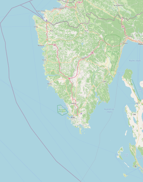
Road map of Istria County in Croatia
| Description |
This map of Istarska županija was created from OpenStreetMap project data, collected by the community. This map may be incomplete, and may contain errors. Don't rely solely on it for navigation. |
| Date | (see file history) |
| Source | openstreetmap.org |
| Creator |
OpenStreetMap contributors |
| Permission (Reusing this file) |
OpenStreetMap data and maps are licensed under the Creative Commons Attribution-ShareAlike 2.0 license (CC-BY-SA 2.0). This file is licensed under the Creative Commons Attribution-Share Alike 2.0 Generic license.
|
| Georeferencing | If inappropriate please set warp_status = skip to hide. |
File history
Click on a date/time to view the file as it appeared at that time.
| Date/Time | Thumbnail | Dimensions | User | Comment | |
|---|---|---|---|---|---|
| current | 08:46, 13 December 2022 | | 1,268 × 1,620 (81.06 MB) | Argo Navis (talk | contribs) | coordinates arew wrong, Reverted to version as of 10:21, 10 February 2022 (UTC) |
| 22:08, 29 November 2022 |  | 623 × 905 (1.48 MB) | Silverije (talk | contribs) | Reverted to version as of 23:19, 9 January 2022 (UTC) | |
| 10:21, 10 February 2022 |  | 1,268 × 1,620 (81.06 MB) | Argo Navis (talk | contribs) | Reverted to version as of 22:00, 6 February 2021 (UTC), coordinates are wrong | |
| 23:19, 9 January 2022 |  | 623 × 905 (1.48 MB) | Silverije (talk | contribs) | Reverted to version as of 20:50, 8 March 2010 (UTC) | |
| 22:00, 6 February 2021 |  | 1,268 × 1,620 (81.06 MB) | Vedran V (talk | contribs) | Updated version of map | |
| 21:48, 6 February 2021 |  | 1,380 × 1,763 (97.96 MB) | Vedran V (talk | contribs) | Reverting to updated version of map | |
| 02:37, 8 November 2019 |  | 623 × 905 (1.48 MB) | Ex13 (talk | contribs) | Reverted to version as of 20:50, 8 March 2010 (UTC) | |
| 19:35, 20 October 2019 |  | 1,380 × 1,763 (97.96 MB) | Vedran V (talk | contribs) | Updated version of map | |
| 20:50, 8 March 2010 |  | 623 × 905 (1.48 MB) | Ex13 (talk | contribs) | {{OpenStreetMap|location=Istarska županija}} Category:Istria County Category:Maps of counties of Croatia |
You cannot overwrite this file.
File usage on Commons
There are no pages that use this file.
File usage on other wikis
The following other wikis use this file:
- Usage on bs.wikipedia.org
- Usage on de.wikipedia.org
- Usage on en.wikipedia.org
- Usage on hr.wikipedia.org
- Sveti Juraj (otok kod Vrsara)
- Sveti Jerolim (otok)
- Kozada
- Veruda (otok)
- Uljanik (otok)
- Sveta Katarina (Pulski zaljev)
- Sveti Andrija (Pulski zaljev)
- Vanga
- Ceja
- Fenera
- Bodulaš
- Sveti Nikola (otok kod Poreča)
- Maškin
- Frašker
- Sveti Ivan (Rovinjsko otočje)
- Levan
- Kuvrsada
- Vela Sestrica (Rovinj)
- Gaz (otok)
- Vrsar (otok)
- Galija (Brijuni)
- Pusti (otok)
- Obljak (Mali Brijun)
- Salamun Veli
- Grunj
- Veliki Brijun
- Mali Brijun
- Lunga (Vrsar)
- Figarola
- Fraškerić
- Fenoliga
- Sturag
- Mala Sestrica (Rovinj)
- Veštar
- Pulari
- Premanturski školjić
- Fržital
- Šekovac
- Pomerski školjić
- Gusti Školj
- Supin (otok)
- Raša (rijeka)
- Sveta Katarina (Rovinj)
- Trumbuja
View more global usage of this file.