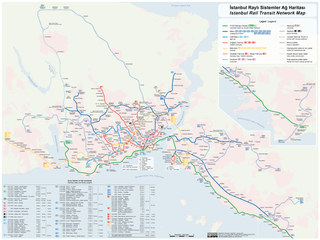
File:Istanbul Rapid Transit Map.png

Original file (4,159 × 3,118 pixels, file size: 2.02 MB, MIME type: image/png)
Captions
Captions

|
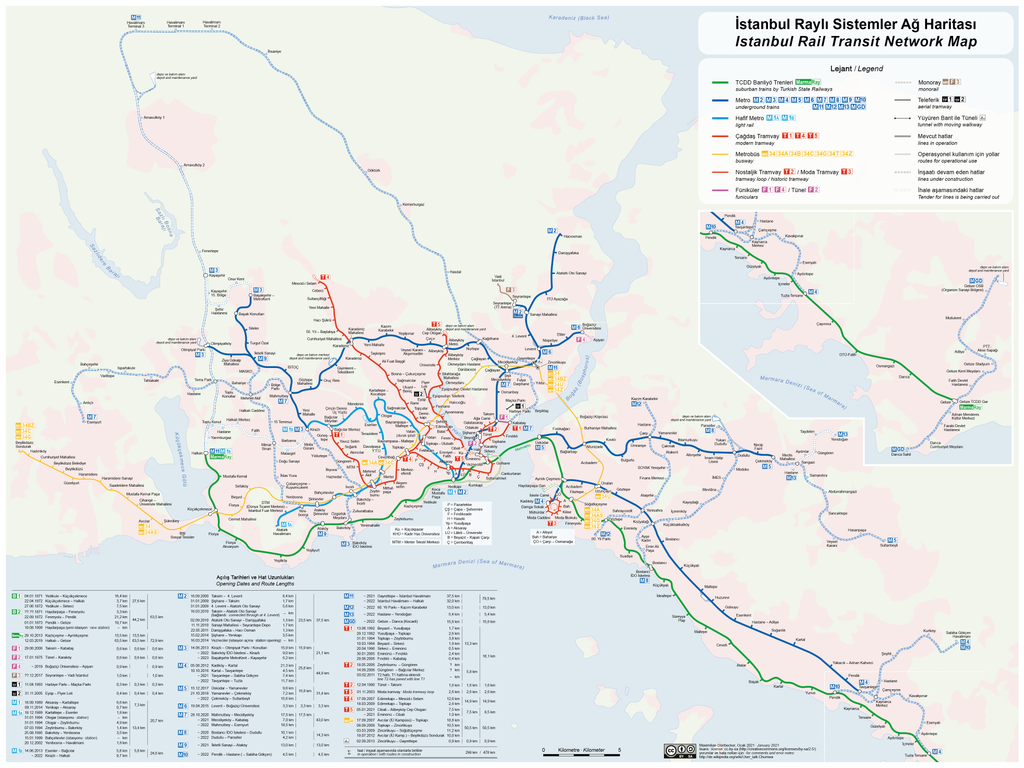
File:Istanbul Railway Systems Network Map.svg is a vector version of this file. It should be used in place of this PNG file when not inferior.
File:Istanbul Rapid Transit Map.png → File:Istanbul Railway Systems Network Map.svg
For more information, see Help:SVG. |
 |
Need Assistance!
I don't live in Turkey and the map basically was drawn after some informations from the Web which are often incorrect or very inaccurate. So if you want the network map as accurate as possible too, please announce your error hints and corrections on my German discussion page.
Thank you in advance!

|
This transport map image could be re-created using vector graphics as an SVG file. This has several advantages; see Commons:Media for cleanup for more information. If an SVG form of this image is available, please upload it and afterwards replace this template with
{{vector version available|new image name}}.
It is recommended to name the SVG file “Istanbul Rapid Transit Map.svg”—then the template Vector version available (or Vva) does not need the new image name parameter. |
| Description |
|
|||
| Date | see file history | |||
| Source | Own work | |||
| Author | Maximilian Dörrbecker (Chumwa) | |||
| Permission (Reusing this file) |
I, the copyright holder of this work, hereby publish it under the following license: This file is licensed under the Creative Commons Attribution-Share Alike 2.5 Generic license.
Sie dürfen das Bild zu den folgenden Bedingungen nutzen:
|
|||
| Other versions |
Current maps:
Older maps (not longer maintained):
|

.png)


.png)
.png)
File history
Click on a date/time to view the file as it appeared at that time.
| Date/Time | Thumbnail | Dimensions | User | Comment | |
|---|---|---|---|---|---|
| current | 06:31, 3 January 2021 | | 4,159 × 3,118 (2.02 MB) | Chumwa (talk | contribs) | update |
| 08:59, 7 November 2020 |  | 4,159 × 3,118 (2 MB) | Chumwa (talk | contribs) | update | |
| 07:57, 13 June 2020 |  | 4,159 × 3,118 (2.03 MB) | Chumwa (talk | contribs) | update | |
| 19:34, 1 April 2019 |  | 3,993 × 3,118 (1.99 MB) | Chumwa (talk | contribs) | ||
| 19:05, 31 March 2019 |  | 3,993 × 3,118 (1.98 MB) | Chumwa (talk | contribs) | corr | |
| 17:33, 31 March 2019 |  | 3,993 × 3,118 (1.97 MB) | Chumwa (talk | contribs) | update | |
| 20:39, 14 March 2019 |  | 3,993 × 2,311 (1.79 MB) | Chumwa (talk | contribs) | update | |
| 20:46, 30 October 2018 |  | 3,993 × 2,311 (1.85 MB) | Chumwa (talk | contribs) | update | |
| 17:36, 26 July 2018 |  | 3,993 × 2,311 (1.86 MB) | Chumwa (talk | contribs) | update | |
| 08:02, 8 July 2018 |  | 3,993 × 2,311 (1.82 MB) | Chumwa (talk | contribs) | update |
You cannot overwrite this file.
File usage on Commons
More than 100 pages use this file. The following list shows the first 100 pages that use this file only. A full list is available.
- Top 200 transport map images that should use vector graphics
- User:Chumwa/Gallery
- User:Chumwa/Istanbul.kml
- User:Chumwa/Istanbul Public Transport Maps
- User:Chumwa/OgreBot/Potential transport maps/2016 August 21-31
- User:Chumwa/OgreBot/Potential transport maps/2016 December 11-20
- User:Chumwa/OgreBot/Potential transport maps/2016 June 1-10
- User:Chumwa/OgreBot/Potential transport maps/2016 May 1-10
- User:Chumwa/OgreBot/Potential transport maps/2016 November 11-20
- User:Chumwa/OgreBot/Potential transport maps/2016 November 21-30
- User:Chumwa/OgreBot/Potential transport maps/2017 April 21-30
- User:Chumwa/OgreBot/Potential transport maps/2017 December 11-20
- User:Chumwa/OgreBot/Potential transport maps/2017 December 21-31
- User:Chumwa/OgreBot/Potential transport maps/2018 July 1-10
- User:Chumwa/OgreBot/Potential transport maps/2018 July 21-31
- User:Chumwa/OgreBot/Potential transport maps/2018 October 21-31
- User:Chumwa/OgreBot/Public transport information/2015 April 11-20
- User:Chumwa/OgreBot/Public transport information/2015 August 11-20
- User:Chumwa/OgreBot/Public transport information/2015 February 1-9
- User:Chumwa/OgreBot/Public transport information/2015 June 11-20
- User:Chumwa/OgreBot/Public transport information/2015 May 1-10
- User:Chumwa/OgreBot/Public transport information/2016 August 21-31
- User:Chumwa/OgreBot/Public transport information/2016 December 11-20
- User:Chumwa/OgreBot/Public transport information/2016 June 1-10
- User:Chumwa/OgreBot/Public transport information/2016 May 1-10
- User:Chumwa/OgreBot/Public transport information/2016 November 11-20
- User:Chumwa/OgreBot/Public transport information/2016 November 21-30
- User:Chumwa/OgreBot/Public transport information/2017 April 21-30
- User:Chumwa/OgreBot/Public transport information/2017 December 11-20
- User:Chumwa/OgreBot/Public transport information/2017 December 21-31
- User:Chumwa/OgreBot/Public transport information/2018 July 1-10
- User:Chumwa/OgreBot/Public transport information/2018 July 21-31
- User:Chumwa/OgreBot/Public transport information/2018 October 21-31
- User:Chumwa/OgreBot/Public transport information/2019 March 11-20
- User:Chumwa/OgreBot/Transport Maps/2015 April 11-20
- User:Chumwa/OgreBot/Transport Maps/2015 August 11-20
- User:Chumwa/OgreBot/Transport Maps/2015 February 1-9
- User:Chumwa/OgreBot/Transport Maps/2015 June 11-20
- User:Chumwa/OgreBot/Transport Maps/2015 May 1-10
- User:Chumwa/OgreBot/Transport Maps/2016 August 21-31
- User:Chumwa/OgreBot/Transport Maps/2016 December 11-20
- User:Chumwa/OgreBot/Transport Maps/2016 June 1-10
- User:Chumwa/OgreBot/Transport Maps/2016 May 1-10
- User:Chumwa/OgreBot/Transport Maps/2016 November 11-20
- User:Chumwa/OgreBot/Transport Maps/2016 November 21-30
- User:Chumwa/OgreBot/Transport Maps/2017 April 21-30
- User:Chumwa/OgreBot/Transport Maps/2017 December 11-20
- User:Chumwa/OgreBot/Transport Maps/2017 December 21-31
- User:Chumwa/OgreBot/Transport Maps/2018 July 1-10
- User:Chumwa/OgreBot/Transport Maps/2018 July 21-31
- User:Chumwa/OgreBot/Transport Maps/2018 October 21-31
- User:Chumwa/OgreBot/Transport Maps/2019 March 11-20
- User:Chumwa/OgreBot/Travel and communication maps/2016 August 21-31
- User:Chumwa/OgreBot/Travel and communication maps/2016 December 11-20
- User:Chumwa/OgreBot/Travel and communication maps/2016 June 1-10
- User:Chumwa/OgreBot/Travel and communication maps/2016 May 1-10
- User:Chumwa/OgreBot/Travel and communication maps/2016 November 11-20
- User:Chumwa/OgreBot/Travel and communication maps/2016 November 21-30
- User:Chumwa/OgreBot/Travel and communication maps/2017 April 21-30
- User:Chumwa/OgreBot/Travel and communication maps/2017 December 11-20
- User:Chumwa/OgreBot/Travel and communication maps/2017 December 21-31
- User:Chumwa/OgreBot/Travel and communication maps/2018 July 1-10
- User:Chumwa/OgreBot/Travel and communication maps/2018 July 21-31
- User:Chumwa/OgreBot/Travel and communication maps/2018 October 21-31
- User:Chumwa/OgreBot/Travel and communication maps/2019 March 11-20
- User:Chumwa/OtherVersions - Public transport Maps - Istanbul
- User:Liesel/Rail transport/2015 February 1-9
- File:Istanbul M2 Linienband.png
- File:Istanbul M3 Linienband.png
- File:Istanbul M4 Linienband.png
- File:Istanbul Metrobüs Lines.png
- File:Istanbul Rapid Transit Map.png
- File:Istanbul Rapid Transit Map (including future projects).png
- File:Istanbul Rapid Transit Map (schematic).png
- File:Istanbul Rapid Transit Map with Metrobüs (schematic).png
- File:Istanbul public transport - Banliyö Treni line symbol.png
- File:Istanbul public transport - F1 line symbol.png
- File:Istanbul public transport - M1 line symbol.png
- File:Istanbul public transport - M2 line symbol.png
- File:Istanbul public transport - M3 line symbol.png
- File:Istanbul public transport - M4 line symbol.png
- File:Istanbul public transport - M5 line symbol.png
- File:Istanbul public transport - M6 line symbol.png
- File:Istanbul public transport - M7 line symbol.png
- File:Istanbul public transport - M8 line symbol.png
- File:Istanbul public transport - M9 line symbol.png
- File:Istanbul public transport - MM line symbol.png
- File:Istanbul public transport - Metrobüs line symbol.png
- File:Istanbul public transport - Nostaljik Tramvay symbol.png
- File:Istanbul public transport - T1 line symbol.png
- File:Istanbul public transport - T3 line symbol.png
- File:Istanbul public transport - T4 line symbol.png
- File:Istanbul public transport - Teleferik line symbol.png
- File:Istanbul public transport - Tünel line symbol.png
- File:Istanbul public transport icons.svg
- File:Map of the Districts of Istanbul.png
- File:Map of the Istanbul Metro line M1A and M1B.png
- File:Map of the Istanbul Metrobüs.png
- File:Metrobüs - Fahrtenangebot.png
- File:SchienenverkehrIstanbul2006.png
View more links to this file.
File usage on other wikis
The following other wikis use this file:
- Usage on ca.wikipedia.org
- Usage on de.wikipedia.org
- Benutzer:Chumwa
- Diskussion:Marmaray
- Benutzer Diskussion:Chumwa/Archiv/2010/1. Quartal
- Benutzer Diskussion:Chumwa/Archiv/2011/1. Quartal
- Wikipedia:Kartenwerkstatt/Karte des Tages/Galerie
- Benutzer:Chumwa/SomeOfMyFiles
- Benutzer Diskussion:Chumwa/Archiv/2016/2. Quartal
- Benutzer Diskussion:Chumwa/Archiv/2016/4. Quartal
- Benutzer Diskussion:Chumwa/Archiv/2017/2. Quartal
- Benutzer Diskussion:Chumwa/Archiv/2020/4. Quartal
- Benutzer Diskussion:Chumwa/Archiv/2022/4. Quartal
- Usage on en.wikipedia.org
- Usage on fr.wikipedia.org
- Usage on ru.wikipedia.org
- Тюнель
- Стамбульский трамвай
- Мармарай
- Стамбульский метрополитен
- Общественный транспорт Стамбула
- Линия 2 (Стамбульский метрополитен)
- Линия 3 (Стамбульский метрополитен)
- Линия 6 (Стамбульский метрополитен)
- Линия 1 (Стамбульский метрополитен)
- Линия 5 (Стамбульский метрополитен)
- Линия 4 (Стамбульский метрополитен)
- İstanbul Deniz Otobüsleri
- Istanbulkart
- Фуникулёр Кабаташ—Таксим
- Эюп (канатная дорога)
- Мачка (канатная дорога)
- Линия 7 (Стамбульский метрополитен)
- Линия 8 (Стамбульский метрополитен)
- Линия 9 (Стамбульский метрополитен)
- Шаблон:Общественный транспорт Стамбула
- Metro Istanbul