File:Isle of Man TT Course (OpenStreetMap).svg
Jump to navigation
Jump to search

Size of this PNG preview of this SVG file: 492 × 600 pixels. Other resolutions: 197 × 240 pixels | 394 × 480 pixels | 630 × 768 pixels | 840 × 1,024 pixels | 1,681 × 2,048 pixels | 549 × 669 pixels.
Original file (SVG file, nominally 549 × 669 pixels, file size: 1.04 MB)
Captions
Captions
Add a one-line explanation of what this file represents
| Description |
English:
Source: Open Street Map of the Isle of Man |
||||||||||||
| Date | |||||||||||||
| Source | OpenStreetMap | ||||||||||||
| Author | Dan Karran | ||||||||||||
| Permission (Reusing this file) |
This file is licensed under the Creative Commons Attribution-Share Alike 2.0 Generic license.
|
||||||||||||
| Other versions | Isle of Man TT Course (OpenStreetMap).png | ||||||||||||
| SVG development |
.png)
| Camera location | | View this and other nearby images on: OpenStreetMap |
|---|
.svg¶ms=054.229070_N_-004.445000_E_globe:Earth_type:camera__&language=en)
File history
Click on a date/time to view the file as it appeared at that time.
| Date/Time | Thumbnail | Dimensions | User | Comment | |
|---|---|---|---|---|---|
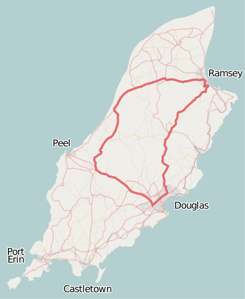
| current | 16:43, 16 September 2008 | | 549 × 669 (1.04 MB) | Dankarran (talk | contribs) | {{openstreetmap|name=Isle of Man}} {{Information |Description={{en|1= Overview map of the Isle of Man from OpenStreetMap project with the Snaefell mountain course course highlighted. Source: [http://www.openstreetmap.org/index.html?lat=54.22907&l |
| 08:40, 16 September 2008 |  | 549 × 669 (1.05 MB) | Dankarran (talk | contribs) | {{Information |Description={{en|1={{openstreetmap|name=Isle of Man}} Overview map of the Isle of Man from OpenStreetMap project with the Snaefell mountain course course highlighted. Source: [http://www.openstreetmap.org/index.html?lat=54.22907&l | |
| 00:18, 16 September 2008 |  | 549 × 669 (1.05 MB) | Dankarran (talk | contribs) | {{Information |Description={{en|1={{openstreetmap|name=Isle of Man}} Overview map of the Isle of Man from OpenStreetMap project with the Snaefell mountain course course highlighted. Source: [http://www.openstreetmap.org/index.html?lat=54.22907&l |
You cannot overwrite this file.
File usage on Commons
The following 4 pages use this file:
File usage on other wikis
The following other wikis use this file:
- Usage on ca.wikipedia.org
- Usage on de.wikipedia.org
- Usage on en.wikipedia.org
- Isle of Man TT
- 2006 Isle of Man TT
- Manx Grand Prix
- 2005 Isle of Man TT
- 2002 Isle of Man TT
- 2000 Isle of Man TT
- 1996 Isle of Man TT
- 1995 Isle of Man TT
- Isle of Man TT Mountain Course
- 2007 Isle of Man TT
- 1949 Isle of Man TT
- 1954 Isle of Man TT
- 1955 Isle of Man TT
- 1952 Isle of Man TT
- 1956 Isle of Man TT
- 1960 Isle of Man TT
- 2008 Isle of Man TT
- List of Grand Prix motorcycle circuits
- 2009 Isle of Man TT
- 2010 Isle of Man TT
- 2011 Isle of Man TT
- 2012 Isle of Man TT
- 1976 Isle of Man TT
- 1977 Isle of Man TT
- 2013 Isle of Man TT
- 2014 Isle of Man TT
- List of named corners of the Snaefell Mountain Course
- 2016 Isle of Man TT
- 1975 Isle of Man TT
- 1986 Isle of Man TT
- 2019 Isle of Man TT
- 2023 Isle of Man TT
- 2022 Isle of Man TT
- 2018 Isle of Man TT
- 2017 Isle of Man TT
- 2015 Isle of Man TT
- 2004 Isle of Man TT
- 2003 Isle of Man TT
- 1999 Isle of Man TT
- 1998 Isle of Man TT
- 1997 Isle of Man TT
- 1992 Isle of Man TT
- 2024 Isle of Man TT
- Usage on es.wikipedia.org
- Usage on eu.wikipedia.org
- Usage on id.wikipedia.org
View more global usage of this file.
.svg)
.svg&oldid=769086016)