File:Islands of UAE, E Qatar 2a.jpg
Jump to navigation
Jump to search

Size of this preview: 800 × 556 pixels. Other resolutions: 320 × 222 pixels | 640 × 444 pixels | 1,024 × 711 pixels | 1,280 × 889 pixels | 2,560 × 1,778 pixels | 4,967 × 3,449 pixels.
Original file (4,967 × 3,449 pixels, file size: 1.66 MB, MIME type: image/jpeg)
Captions
Captions
Add a one-line explanation of what this file represents
Summary[edit]
| Description |
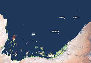
English: Map showing islands of Eastern Qatar and the United Arab Emirates, including Sir Abu Nu'ayr (Sir Abu Nuer). |
| Date | |
| Source | NOAA |
| Author | NOAA, DBrnstn |
Licensing[edit]
This image is in the public domain because it contains materials that originally came from the U.S. National Oceanic and Atmospheric Administration, taken or made as part of an employee's official duties.
|
Categories[edit]
File history
Click on a date/time to view the file as it appeared at that time.
| Date/Time | Thumbnail | Dimensions | User | Comment | |
|---|---|---|---|---|---|
| current | 12:28, 28 November 2009 | | 4,967 × 3,449 (1.66 MB) | DBrnstn~commonswiki (talk | contribs) | {{Information |Description={{en|1=Map showing islands of Eastern Qatar and the United Arab Emirates, including Sir Abu Nu'ayr (Sir Abu Nuer). }} |Source=NOAA |Author=NOAA, DBrnstn |Date=2005-06-15 |Permission= |other_versions= }} |
You cannot overwrite this file.
File usage on Commons
There are no pages that use this file.
File usage on other wikis
The following other wikis use this file:
- Usage on ar.wikipedia.org
- جزيرة السينية
- طنب الكبرى
- طنب الصغرى
- جزيرة أبو موسى
- حضارة أم النار
- جزيرة دلما
- جزيرة أبو ظبي
- جزيرة ياس
- قائمة جزر الخليج العربي
- جزيرة داس
- الجزيرة الحمراء
- جزيرة اللؤلؤ
- جزيرة بوطينة
- قائمة جزر الإمارات العربية المتحدة
- قالب:جزر الإمارات
- جزيرة السعديات
- جزيرة أرزنة
- جزيرة زركوه
- جزيرة دينا
- جزيرة قرنين
- جزيرة عش
- جزيرة أبو الأبيض
- جزيرة غاغة
- Usage on de.wikipedia.org