File:Island of Guadalupe.jpg
Jump to navigation
Jump to search

Size of this preview: 724 × 600 pixels. Other resolutions: 290 × 240 pixels | 580 × 480 pixels | 927 × 768 pixels | 1,237 × 1,024 pixels | 2,473 × 2,048 pixels | 4,096 × 3,392 pixels.
Original file (4,096 × 3,392 pixels, file size: 8.88 MB, MIME type: image/jpeg)
Captions
Captions
Add a one-line explanation of what this file represents
Summary[edit]
| Description |
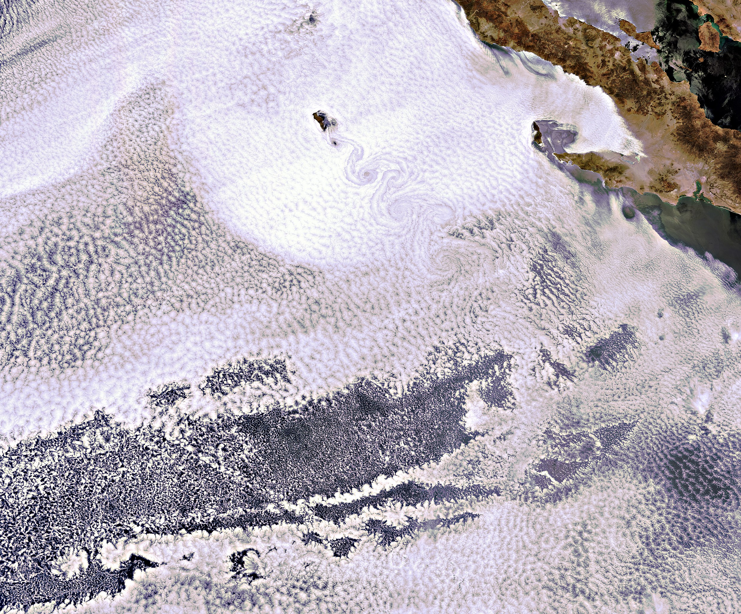
English: This Envisat image, acquired on 15 June 2011, shows the volcanic island of Guadalupe peeking through the clouds. The island lies in the Pacific Ocean around 250 km off the west coast of Mexico's Baja California peninsula. The swirling clouds to the south of the island are the result of a meteorological phenomenon known as a 'von Karman vortex'. As wind-driven clouds encounter Guadalupe, they flow around the high volcanic outcrop to form the large spinning eddies that can clearly be seen in the image. |
| Date | |
| Source | http://www.esa.int/spaceinimages/Images/2011/07/Island_of_Guadalupe |
| Author | European Space Agency |
| Permission (Reusing this file) |
ESA,CC BY-SA 3.0 IGO |
| Other versions |
|
| Title | Island of Guadalupe |
| Keywords | Atmosphere |
| Set | Earth observation image of the week |
| Mission | Envisat |
| Activity | Observing the Earth |

Licensing[edit]
This file is licensed under the Creative Commons Attribution-ShareAlike 3.0 IGO license.
Attribution: ESA
- You are free:
- to share – to copy, distribute and transmit the work
- to remix – to adapt the work
- Under the following conditions:
- attribution – You must give appropriate credit, provide a link to the license, and indicate if changes were made. You may do so in any reasonable manner, but not in any way that suggests the licensor endorses you or your use.
- share alike – If you remix, transform, or build upon the material, you must distribute your contributions under the same or compatible license as the original.
File history
Click on a date/time to view the file as it appeared at that time.
| Date/Time | Thumbnail | Dimensions | User | Comment | |
|---|---|---|---|---|---|
| current | 06:23, 24 February 2017 | | 4,096 × 3,392 (8.88 MB) | Revent (talk | contribs) | =={{int:filedesc}}== {{Photograph |photographer = Envisat satellite |title = Island of Guadalupe |description = {{en|This Envisat image, acquired on 15 June 2011, shows the volcanic island of Guadalupe peeking through the c... |
You cannot overwrite this file.
File usage on Commons
The following page uses this file: