File:Isabela Channel and Sulu Sea.jpg
Jump to navigation
Jump to search

Size of this preview: 799 × 599 pixels. Other resolutions: 320 × 240 pixels | 640 × 480 pixels | 1,024 × 768 pixels | 1,280 × 960 pixels | 2,560 × 1,920 pixels | 3,929 × 2,947 pixels.
Original file (3,929 × 2,947 pixels, file size: 6.01 MB, MIME type: image/jpeg)
Captions
Captions
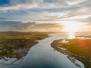
Sun setting on Sulu sea on the west end of Isabela Channel
Summary
[edit]
| Description |
English: On the northern coast of Isabela City, Basilan Province is the Isabela Channel. A body of water separated by Malamawi Island and Isabela City, Basilan Island. Isabela Channel is deep enough for small ships to navigate and has been a waterway for small “bangkas” to travel to and from Isabela City and Malamawi Island. The photo is taken via drone camera. This is during sunset. The sun sets in the other end of the channel which I also a part of Sulu Sea. |
| Date | |
| Source | Own work |
| Author | Aldous Mariano Cariño |
| Camera location | | View this and other nearby images on: OpenStreetMap |
|---|
Licensing
[edit]
I, the copyright holder of this work, hereby publish it under the following license:
This file is licensed under the Creative Commons Attribution-Share Alike 4.0 International license.
- You are free:
- to share – to copy, distribute and transmit the work
- to remix – to adapt the work
- Under the following conditions:
- attribution – You must give appropriate credit, provide a link to the license, and indicate if changes were made. You may do so in any reasonable manner, but not in any way that suggests the licensor endorses you or your use.
- share alike – If you remix, transform, or build upon the material, you must distribute your contributions under the same or compatible license as the original.
This image was uploaded as part of Wiki Loves Earth 2022.
|
 |
File history
Click on a date/time to view the file as it appeared at that time.
| Date/Time | Thumbnail | Dimensions | User | Comment | |
|---|---|---|---|---|---|
| current | 03:17, 18 May 2022 | | 3,929 × 2,947 (6.01 MB) | AldousMC (talk | contribs) | Uploaded own work with UploadWizard |
You cannot overwrite this file.
File usage on Commons
There are no pages that use this file.
File usage on other wikis
The following other wikis use this file:
- Usage on lv.wikipedia.org