File:Irrawaddy Delta (MODIS 2016-11-28).jpg

Original file (1,844 × 1,364 pixels, file size: 278 KB, MIME type: image/jpeg)
Captions
Captions
Summary[edit]
.jpg&action=edit§ion=1)
| Description |
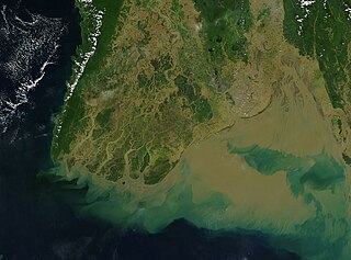
English: Muddy brown sediment poured from the Irrawaddy Delta at the end of a long and extremely wet monsoonal season in 2016. The Moderate Resolution Imaging Spectroradiometer (MODIS) aboard NASA’s Aqua satellite captured this true-color image on November 19.
The rainy season in Myanmar (Burma) begins in mid-May and typically ends in mid-November. According to Relief Web, floods brought by monsoon rains began pounding parts of Myanmar in late July, displacing at least 377,000 people from their homes as the waters gradually moved south towards the Irrawaddy Delta. By mid-October, the worst of the rains had passed and the floodwaters were receding; however, the waterways along the Delta continued to pour sediment into the Gulf of Martaban (east) and the Andaman Sea. Although increased by the monsoon, such sediment is not unusual – it has been estimated that the Irrawaddy River is likely the third-largest contributor of sediment load in the world. The delta of the Irrawaddy River begins about 58 miles (93 km) above the port city of Hinthada (Henzada) and spreads about 180 km (290 km) southward to the Andaman Sea. The region is heavily populated, and also is intensively cropped for rice. Much of the delta lies only about 9.8 feet (3 meters) above sea level, while the ocean floor is very shallow (less than 18 feet/5.5 meters). The soil consists of fine silt, which has been carried down the muddy river channels and deposited as the water speed slows as it approaches the Andaman Sea. |
||
| Date | Taken on 19 November 2016 | ||
| Source |
|
||
| Author | Jeff Schmaltz, MODIS Land Rapid Response Team, NASA GSFC |
| This media is a product of the Aqua mission Credit and attribution belongs to the mission team, if not already specified in the "author" row |
Licensing[edit]
.jpg&action=edit§ion=2)
| This file is in the public domain in the United States because it was solely created by NASA. NASA copyright policy states that "NASA material is not protected by copyright unless noted". (See Template:PD-USGov, NASA copyright policy page or JPL Image Use Policy.) | ||
 |
Warnings:
|
File history
Click on a date/time to view the file as it appeared at that time.
| Date/Time | Thumbnail | Dimensions | User | Comment | |
|---|---|---|---|---|---|
| current | 19:12, 15 February 2024 | | 1,844 × 1,364 (278 KB) | OptimusPrimeBot (talk | contribs) | #Spacemedia - Upload of http://modis.gsfc.nasa.gov/gallery/images/image11282016_250m.jpg via Commons:Spacemedia |
You cannot overwrite this file.
File usage on Commons
There are no pages that use this file.
.jpg&oldid=852064826)