File:Irrawaddy Delta, Myanmar ESA381810.jpg

Original file (3,000 × 2,389 pixels, file size: 9.9 MB, MIME type: image/jpeg)
Captions
Captions
Summary[edit]
| Description |
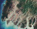
English: The Sentinel-2A satellite takes us over the peninsulas and islands of the Irrawaddy Delta in Myanmar.
Click on the box in the lower-right corner to view this image at its full 10 m resolution directly in your browser. With a length of over 2200 km, the Irrawaddy River is the country's largest, flowing north-to-south before fanning out into the delta and emptying into the Andaman Sea. Evident by the brown colour of the rivers and streams, sediments carried by the water are deposited in the delta. These deposits make the area very fertile, and the accumulation of deposits over time causes the coastline to advance. Owing to the rich soils, the region is the country’s largest rice producer. This image was captured in March after the harvesting season but before the planting, so bare ground appears beige. Green areas show dense mangrove forests, especially the Mein-ma-hla Kyun Wildlife Sanctuary in the lower right, known for its saltwater crocodiles. Even though this area is protected, some villagers living on the banks nearby sneak into the sanctuary and chop down trees for wood, degrading the forest. Wood collection, rice farming and fishing – these and other human activities have damaged the delta’s mangroves over the years. When Cyclone Nargis hit in 2008, the remaining mangrove forests were not enough to act as a natural buffer against the storm surge, and resulted in an extensive loss of life. This image, also featured on theEarth from Space video programme, combines two acquisitions by the Copernicus Sentinel-2A satellite in March 2017. |
| Date | |
| Source | http://www.esa.int/spaceinimages/Images/2017/07/Irrawaddy_Delta_Myanmar |
| Author | European Space Agency |
| Permission (Reusing this file) |
contains modified Copernicus Sentinel data (2017), processed by ESA,CC BY-SA 3.0 IGO |
| Other versions |
|
| Title | Irrawaddy Delta, Myanmar |
| Set | Earth observation image of the week |
| System | Copernicus |
| Mission | Sentinel-2 |
| Location | Myanmar |
| Activity | Observing the Earth |
| Keywords | River delta; Satellite image; Sedimentation; mangrove; Forests and deforestation |
Licensing[edit]
- You are free:
- to share – to copy, distribute and transmit the work
- to remix – to adapt the work
- Under the following conditions:
- attribution – You must give appropriate credit, provide a link to the license, and indicate if changes were made. You may do so in any reasonable manner, but not in any way that suggests the licensor endorses you or your use.
- share alike – If you remix, transform, or build upon the material, you must distribute your contributions under the same or compatible license as the original.

|
This image contains data from a satellite in the Copernicus Programme, such as Sentinel-1, Sentinel-2 or Sentinel-3. Attribution is required when using this image.
Attribution: Contains modified Copernicus Sentinel data {{{year}}}
The use of Copernicus Sentinel Data is regulated under EU law (Commission Delegated Regulation (EU) No 1159/2013 and Regulation (EU) No 377/2014). Relevant excerpts:
Free access shall be given to GMES dedicated data [...] made available through GMES dissemination platforms [...].
Access to GMES dedicated data [...] shall be given for the purpose of the following use in so far as it is lawful:
GMES dedicated data [...] may be used worldwide without limitations in time.
GMES dedicated data and GMES service information are provided to users without any express or implied warranty, including as regards quality and suitability for any purpose. |
File history
Click on a date/time to view the file as it appeared at that time.
| Date/Time | Thumbnail | Dimensions | User | Comment | |
|---|---|---|---|---|---|
| current | 16:00, 28 July 2017 | | 3,000 × 2,389 (9.9 MB) | Fæ (talk | contribs) | European Space Agency, Id 381810, http://www.esa.int/spaceinimages/Images/2017/07/Irrawaddy_Delta_Myanmar, User:Fæ/Project_list/ESA |
You cannot overwrite this file.
File usage on Commons
The following 2 pages use this file:
.jpg&redirect=no)
File usage on other wikis
The following other wikis use this file:
- Usage on la.wikipedia.org