File:Irish ferries route map.svg
Jump to navigation
Jump to search

Size of this PNG preview of this SVG file: 449 × 593 pixels. Other resolutions: 182 × 240 pixels | 363 × 480 pixels | 581 × 768 pixels | 775 × 1,024 pixels | 1,551 × 2,048 pixels.
Original file (SVG file, nominally 449 × 593 pixels, file size: 33 KB)
Captions
Captions
Add a one-line explanation of what this file represents
Summary
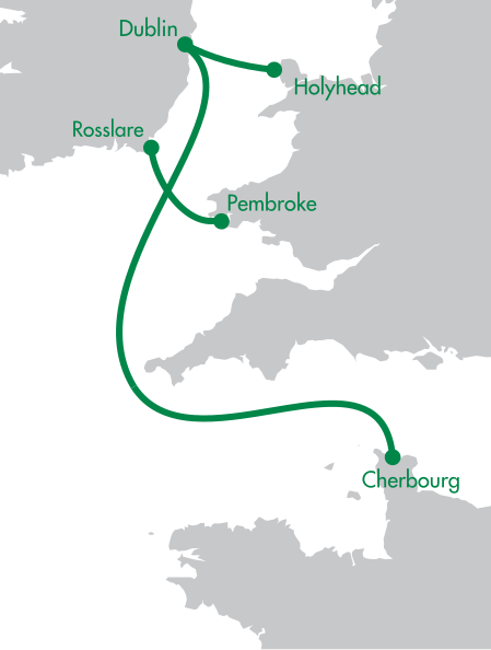
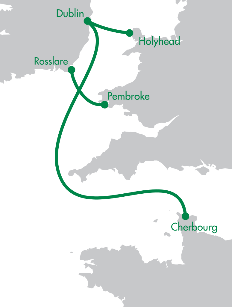
[edit]| Description | Irish Ferries route map | ||
| Date | |||
| Source | United Kingdom and North-West France.svg by Alexrk2 | ||
| Author | Pethrus; Philphos | ||
| SVG development | This map was created with Adobe Illustrator, and with Inkscape.
|
Licensing
[edit]I, the copyright holder of this work, hereby publish it under the following license:
This file is licensed under the Creative Commons Attribution-Share Alike 3.0 Unported license.
- You are free:
- to share – to copy, distribute and transmit the work
- to remix – to adapt the work
- Under the following conditions:
- attribution – You must give appropriate credit, provide a link to the license, and indicate if changes were made. You may do so in any reasonable manner, but not in any way that suggests the licensor endorses you or your use.
- share alike – If you remix, transform, or build upon the material, you must distribute your contributions under the same or compatible license as the original.
Original upload log
[edit]This image is a derivative work of the following images:
- United Kingdom and North-West France.svg licensed with Cc-by-sa-3.0
- 2010-04-26T11:43:17Z Pethrus 270x482 (59564 Bytes) {{Information |Description={{en|Map of the United Kingdom and the North-East of France}}{{fr|Carte des îles britanniques et du Nord-Ouest de la France}} |Source=*[[:File:Europe_blank_laea_location_map.svg|]] |Date=2010-04-26
Uploaded with derivativeFX

File history
Click on a date/time to view the file as it appeared at that time.
| Date/Time | Thumbnail | Dimensions | User | Comment | |
|---|---|---|---|---|---|
| current | 18:05, 18 March 2019 | | 449 × 593 (33 KB) | Joe200576 (talk | contribs) | Updated routes |
| 21:16, 29 November 2013 |  | 449 × 593 (36 KB) | Joe200576 (talk | contribs) | added new route | |
| 17:25, 29 April 2011 |  | 449 × 593 (35 KB) | Joe200576 (talk | contribs) | vector joins fixed / colour adjusted | |
| 17:12, 29 October 2010 |  | 449 × 593 (45 KB) | Joe200576 (talk | contribs) | Colours changed to match company logo | |
| 15:50, 29 October 2010 |  | 449 × 593 (45 KB) | Joe200576 (talk | contribs) | {{Information |Description=Irish Ferries route map |Source=*File:United_Kingdom_and_North-West_France.svg |Date=2010-10-29 15:48 (UTC) |Author=*File:United_Kingdom_and_North-West_France.svg: *[[:File:Europe_blank_laea_location_map.svg|Europe_b |
You cannot overwrite this file.
File usage on Commons
The following page uses this file:
File usage on other wikis
The following other wikis use this file:
- Usage on de.wikipedia.org
- Usage on en.wikipedia.org
- Usage on et.wikipedia.org
- Usage on eu.wikipedia.org
- Usage on fr.wikipedia.org