File:Ioke 2006-08-31 0205Z.jpg
Jump to navigation
Jump to search

Size of this preview: 500 × 600 pixels. Other resolutions: 200 × 240 pixels | 400 × 480 pixels | 640 × 768 pixels | 853 × 1,024 pixels | 1,707 × 2,048 pixels | 8,000 × 9,600 pixels.
Original file (8,000 × 9,600 pixels, file size: 8.94 MB, MIME type: image/jpeg)
Captions
Captions
Add a one-line explanation of what this file represents
| Warning | The original file is very high-resolution. It might not load properly or could cause your browser to freeze when opened at full size. |
|---|
Summary[edit]
| Description |
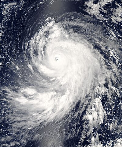
English: Super Typhoon Ioke (01C) over Wake Island |
| Date | |
| Source | https://lance-modis.eosdis.nasa.gov/cgi-bin/imagery/single.cgi?image=Ioke.A2006243.0205.250m.jpg |
| Author | National Aeronautics and Space Administration, LANCE/EOSDIS Rapid Response, captured on Aqua satellite |
| Metadata | https://lance-modis.eosdis.nasa.gov/cgi-bin/imagery/single.cgi?metadata=Ioke.A2006243.0205.txt |
| Satellite | Aqua |
| Camera location | | View this and other nearby images on: OpenStreetMap |
|---|
Licensing[edit]
| This file is in the public domain in the United States because it was solely created by NASA. NASA copyright policy states that "NASA material is not protected by copyright unless noted". (See Template:PD-USGov, NASA copyright policy page or JPL Image Use Policy.) | ||
 |
Warnings:
|
File history
Click on a date/time to view the file as it appeared at that time.
| Date/Time | Thumbnail | Dimensions | User | Comment | |
|---|---|---|---|---|---|
| current | 19:02, 2 February 2012 | | 8,000 × 9,600 (8.94 MB) | Meow (talk | contribs) | Original image. |
| 23:14, 31 August 2006 |  | 8,000 × 9,600 (7.81 MB) | Good kitty (talk | contribs) | == Summary == {{Information |Description=Super Typhoon Ioke started as all tropical cyclones do, as a depression—an area of low atmospheric pressure. After forming August 19, 2006, the depression quickly developed into a tropical storm, the threshold fo |
You cannot overwrite this file.
File usage on Commons
The following 5 pages use this file:
File usage on other wikis
The following other wikis use this file:
- Usage on cs.wikipedia.org
- Usage on de.wikipedia.org
- Usage on en.wikipedia.org
- Usage on ko.wikipedia.org
- Usage on pt.wikipedia.org
- Usage on simple.wikipedia.org
- Usage on zh.wikipedia.org