File:Indus River - Envisat.jpg
Jump to navigation
Jump to search

Size of this preview: 630 × 599 pixels. Other resolutions: 252 × 240 pixels | 505 × 480 pixels | 807 × 768 pixels | 1,076 × 1,024 pixels | 1,440 × 1,370 pixels.
Original file (1,440 × 1,370 pixels, file size: 1.09 MB, MIME type: image/jpeg)
Captions
Captions
Add a one-line explanation of what this file represents
Summary[edit]
| Indus River | |
|---|---|
| Photographer |
Envisat satellite |
| Title |
Indus River |
| Description |
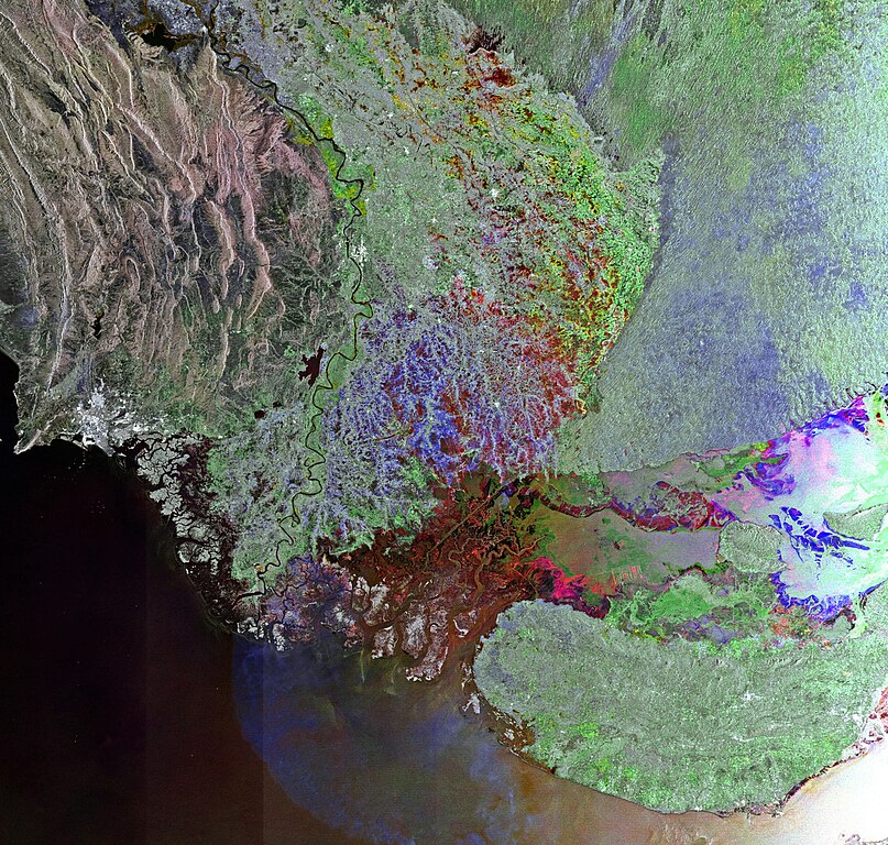
English: This Envisat image shows western India and southern Pakistan, with the Indus River snaking through Pakistan’s Sindh province before emptying into the Arabian Sea. The red area in the lower-central portion of the image covers a seasonal salt marsh over Pakistan’s border with western India.
This image is a compilation of three passes by Envisat’s radar on 15 May, 14 July and 12 September 2011. Each is assigned a colour (red, green and blue) and combined to produce this representation. The colours reveal changes in the surface between Envisat’s passes. |
| Depicted place | Indus River |
| Date | between 15 May 2011 and 12 September 2011 |
| Collection | European Space Agency |
| Accession number |
231287 |
| Credit line | ESA |
| Source | http://www.esa.int/spaceinimages/Images/2011/12/Indus_River |
Licensing[edit]
This file is licensed under the Creative Commons Attribution-ShareAlike 3.0 IGO license.
- You are free:
- to share – to copy, distribute and transmit the work
- to remix – to adapt the work
- Under the following conditions:
- attribution – You must give appropriate credit, provide a link to the license, and indicate if changes were made. You may do so in any reasonable manner, but not in any way that suggests the licensor endorses you or your use.
- share alike – If you remix, transform, or build upon the material, you must distribute your contributions under the same or compatible license as the original.
File history
Click on a date/time to view the file as it appeared at that time.
| Date/Time | Thumbnail | Dimensions | User | Comment | |
|---|---|---|---|---|---|
| current | 04:41, 23 February 2017 | | 1,440 × 1,370 (1.09 MB) | Revent (talk | contribs) | =={{int:filedesc}}=={{Photograph |photographer = Envisat satellite |title = Indus River |description = {{en|This Envisat image shows western India and southern Pakistan, with the Indus River snaking through Pakistan’s Sin... |
You cannot overwrite this file.
File usage on Commons
The following 3 pages use this file:
File usage on other wikis
The following other wikis use this file:
- Usage on or.wikipedia.org
- Usage on www.wikidata.org