File:Indonesia and the Flores Sea (MODIS 2018-05-04).jpg
Jump to navigation
Jump to search

Size of this preview: 688 × 599 pixels. Other resolutions: 276 × 240 pixels | 551 × 480 pixels | 882 × 768 pixels | 1,175 × 1,024 pixels | 2,351 × 2,048 pixels | 2,929 × 2,552 pixels.
Original file (2,929 × 2,552 pixels, file size: 644 KB, MIME type: image/jpeg)
Captions
Captions
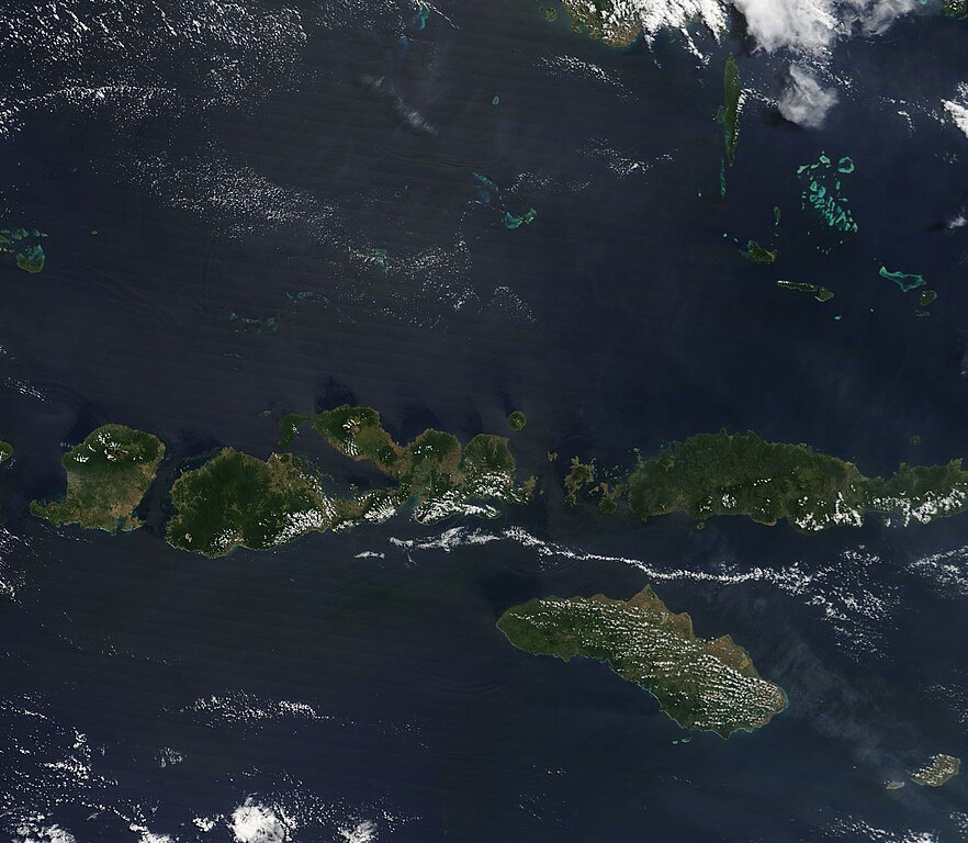
On May 1 2018, NASA’s Terra satellite flew over Indonesia, allowing the Moderate Resolution Imaging Spectroradiometer (MODIS) on board to acquire a true-color image of the Flores Sea and the Lesser Sunda Islands.
Summary[edit]
.jpg&action=edit§ion=1)
| Description |
English: On May 1 2018, NASA’s Terra satellite flew over Indonesia, allowing the Moderate Resolution Imaging Spectroradiometer (MODIS) on board to acquire a true-color image of the Flores Sea and the Lesser Sunda Islands.
The bright blue waters of the Flores Sea stretch more than 93,000 square miles (240,000 square kilometers) from the Lesser Sunda Islands in the south to the island of Celebes in the north. The basin is complex, containing a broad underwater plateau in the west, submarine mounts capped by coral atolls, ridges and troughs, and – just north of the some of the Lesser Sunda Islands – a deep trough that drops 16,860 feet (5,140 meters). The World Wildlife Fund (WWF) notes that the combined waters of the Flores Sea and, to it’s east, the Banda Sea, is considered part of the most complex and biodiverse marine environment in the world, hosting more than 2,000 marine fish species and over 80 genera of corals. They also note that the Lesser Sunda Islands form a series of bio-geographic stepping stones which connect the Australian fauna of Easter Indonesia and Papua New Guinea with the Eurasian fauna of Sumatra and the Southeast Asian Mainland. |
||
| Date | Taken on 1 May 2018 | ||
| Source |
Indonesia and the Flores Sea (direct link)
|
||
| Author | Jeff Schmaltz, MODIS Land Rapid Response Team, NASA GSFC |
| This media is a product of the Terra mission Credit and attribution belongs to the mission team, if not already specified in the "author" row |
Licensing[edit]
.jpg&action=edit§ion=2)
| This file is in the public domain in the United States because it was solely created by NASA. NASA copyright policy states that "NASA material is not protected by copyright unless noted". (See Template:PD-USGov, NASA copyright policy page or JPL Image Use Policy.) | ||
 |
Warnings:
|
File history
Click on a date/time to view the file as it appeared at that time.
| Date/Time | Thumbnail | Dimensions | User | Comment | |
|---|---|---|---|---|---|
| current | 01:46, 17 February 2024 | | 2,929 × 2,552 (644 KB) | OptimusPrimeBot (talk | contribs) | #Spacemedia - Upload of http://modis.gsfc.nasa.gov/gallery/images/image05042018_250m.jpg via Commons:Spacemedia |
You cannot overwrite this file.
File usage on Commons
There are no pages that use this file.
.jpg&oldid=852762336)