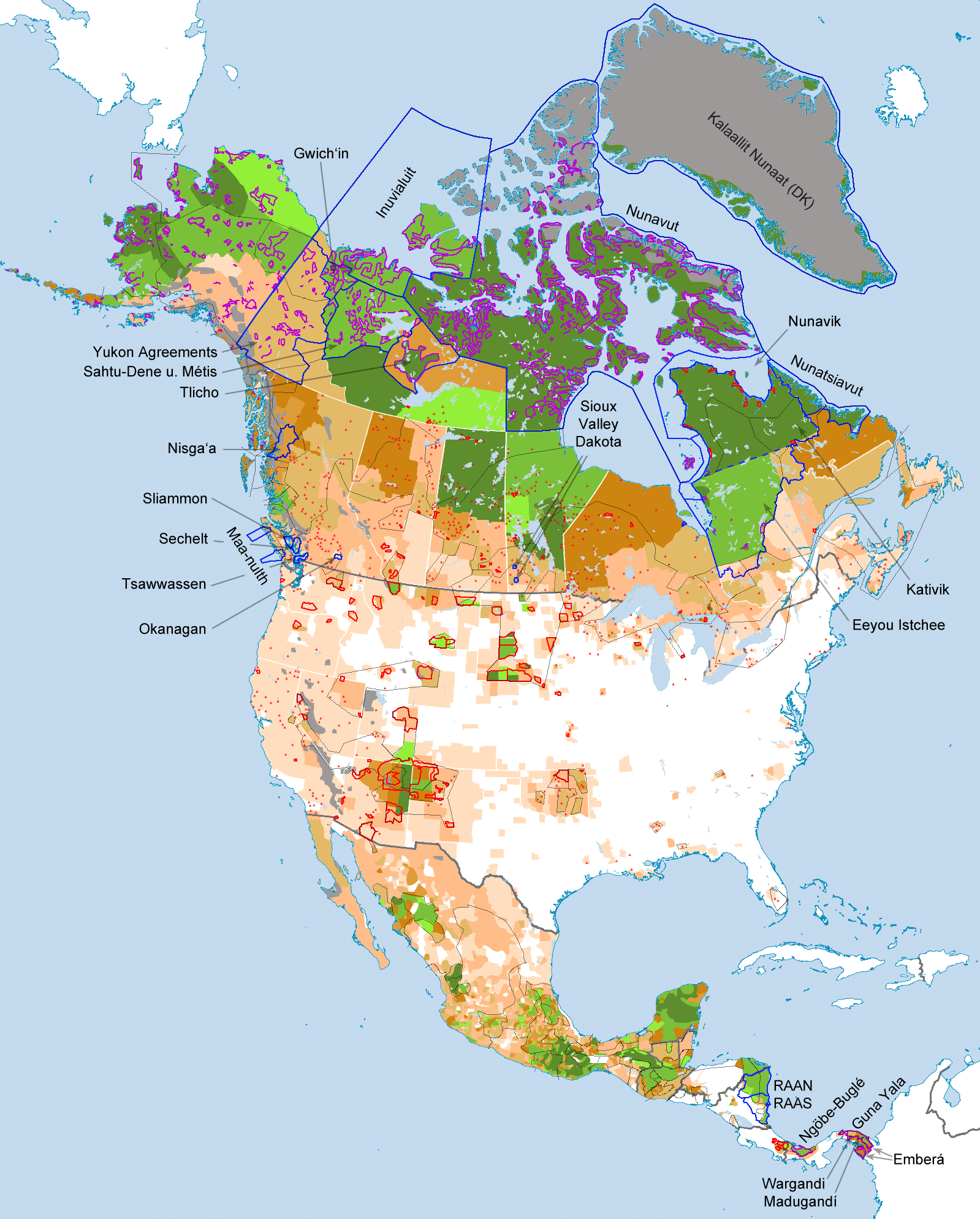
File:Indigenous-peoples-of-North-America,-Population-Density-and-Territories.png
Original file (1,599 × 1,988 pixels, file size: 616 KB, MIME type: image/png)
Captions
Captions
Summary[edit]
| Description |
English: Map of the population density and territories of indigenous peoples of North America at the beginning of the 21st century
Deutsch: Karte der Bevölkerungsdichte und der Territorien der indigenen Gruppen Nordamerikas zu Beginn des 21. Jahrhunderts |
| Date | |
| Source | Own work |
| Author | Fährtenleser |
Legende (German)[edit]
| Anteile indigener Bevölkerungsgruppen nach nationalen Censusregionen >80 %
61–80 %
51–60 %
36–50 %
26–35 %
16–25 %
6–15 %
1–5 %
<1 %
unbewohnbar
|
Von den jeweiligen Staaten anerkannte indigene Territorien 𐌏 Uneingeschränktes Landeigentum |
Legend (English)[edit]
| Portion of the indigenous sections of the population covered to national Census regions >80 %
61–80 %
51–60 %
36–50 %
26–35 %
16–25 %
6–15 %
1–5 %
<1 %
unfit for habitation
|
From the respective countries approved indigenous territories 𐌏 Landed property under private law |
Quellen / Sources[edit]
Abweichungen[edit]
Aufgrund sehr unterschiedlicher Kategorieneinteilungen der verwendeten Kartenquellen können für Mittelamerika (außer Mexiko) in einigen Teilregionen Abweichungen von bis zu 10 %-Punkten vorkommen.
Kartenquellen[edit]
Grundlage: Wikimedia-Karte BLANK_in_North_America_(-mini_map_-rivers).svg/2000px-BLANK_in_North_America_(-mini_map_-rivers).svg.png
Anteile Indigener / Censusgebiete[edit]
- Alaska: Karte zur Übertragung der Censusgebiete + Daten aus Census´ 2010/14
- Restliche USA: Commons-File:Percent_native_american_in_the_U.S._by_census_district_2000.png + Census 2010
- Kanada: Census 2011 + Abgleich mit Subcensus 2006
- Grönland: [1]
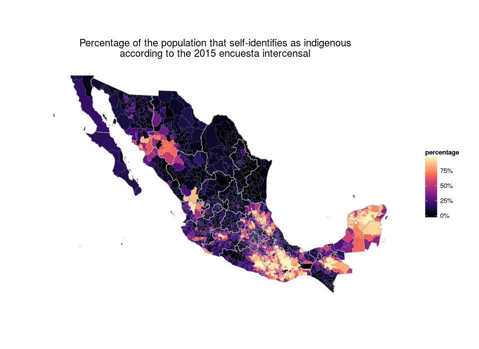
- Mexiko: Selbstzuschreibung als Indigene 2015
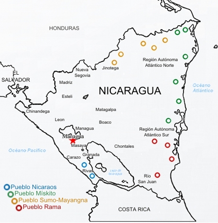
- Mittelamerika: Central-America: Percentage of Self-Identified Indigenous People by Municipio Censuses Guatemala 2002, Belize 2010, Honduras 2001, El Salvador 2007, Nicaragua 2005, Costa Rica 2011, Panama 2010 + Abgleich mit Población indígena porcentual en América Latina, 2015
„Offizielles“ Indianerland[edit]
Nur Flächen, die größer als 250 bis 500 km² (je nach Form) sind in der Karte dargestellt
- Kanada: Vertraglich abgetretenes Landeigentum indianischer Nationen: Modern treaties and Self-Government Agreements (2016) -sowie- Reservationen u.ä.: Karte „Aboriginal Peoples and Lands“ auf geo.aandc-aadnc.gc.ca (2016) -sowie- Commons-File:Kativik.png (2011)
- US-Reservationen: Commons-File:Bia-map-indian-reservations-usa.png (2006)
- Alaska: Who-Owns-Manages-Alaska.gif archive copy at the Wayback Machine auf acmedia.alaskacommons.com (2009)
- Nicaragua: Commons-Files: RAAN,_Nicaragua.svg -und- Region Autonoma del Atlantico Norte in Nicaragua.svg (beide 2010) -sowie- GIZ Länderpapier Nicaragua (Internet Archive)
- Costa Rica: Commons-File: Mapa_General.jpg (2009)
- Panama: Karte zu „Indigenous Comarca lands“ und „Other indigenous claimed lands“ in america.aljazzere.com (2014)
Indigene Völker[edit]
- Nordamerika allg.: Willi Stegner (Hrsg.): TaschenAtlas Völker und Sprachen. 1. Auflage, Klett-Perthes, Gotha 2006, ISBN 978-3-12-828123-0.
- Kanada: Aboriginal Languages in Canada (2009)
- USA: Wiki-Recherchen -sowie- George Fronval u. Frederik Hetmann: Das große Buch der Indianer. Boje, Stuttgart 1973, ISBN 3-414-10730-9. S. 126–127 (Einband innen).
- Mexiko: Commons-Files: Mapa_de_lenguas_de_México_%2B_100_000.png -und- Mapa_de_lenguas_de_México_20.000-100.000.png -und- Mapa_de_lenguas_de_México_-_20_000.png -sowie- Major indigenous groups Tony Burton, 2007 -und- Grupos Indígenas de México Instituto Nacional Indigenista -und- Mapa Lenguas Indígenas Atlas de México, 2010 (Internet Archive)
- Mittelamerika: Indigenous Language Map of Central America
- Nicaragua: Mapa Comunidades Indígenes
- Guatemala: www.pueblosoriginariosenamerica.org: Guatemala (Internet Archive)

|
This map image could be re-created using vector graphics as an SVG file. This has several advantages; see Commons:Media for cleanup for more information. If an SVG form of this image is available, please upload it and afterwards replace this template with
{{vector version available|new image name}}.
It is recommended to name the SVG file “Indigenous-peoples-of-North-America,-Population-Density-and-Territories.svg”—then the template Vector version available (or Vva) does not need the new image name parameter. |
Licensing[edit]
- You are free:
- to share – to copy, distribute and transmit the work
- to remix – to adapt the work
- Under the following conditions:
- attribution – You must give appropriate credit, provide a link to the license, and indicate if changes were made. You may do so in any reasonable manner, but not in any way that suggests the licensor endorses you or your use.
- share alike – If you remix, transform, or build upon the material, you must distribute your contributions under the same or compatible license as the original.
File history
Click on a date/time to view the file as it appeared at that time.
| Date/Time | Thumbnail | Dimensions | User | Comment | |
|---|---|---|---|---|---|
| current | 13:21, 4 June 2022 | | 1,599 × 1,988 (616 KB) | Fährtenleser (talk | contribs) | Korrekturen (Text kleiner, Originalnamen, Grenzen in Quebec), Ergänzungen (Namen in Ost-Kanada) |
| 16:06, 18 December 2016 |  | 1,599 × 1,988 (616 KB) | Fährtenleser (talk | contribs) | {{Information |Description ={{en|1=Map of the population density and territories of indigenous peoples of North America at the beginning of the 21. centuries }} {{de|1=Karte der Bevölkerungsdichte und der Territorien der indigenen Gruppen Nordam... |
You cannot overwrite this file.
File usage on Commons
The following page uses this file:
File usage on other wikis
The following other wikis use this file:
- Usage on de.wikipedia.org
- Usage on en.wikipedia.org