File:Indie 2006.png
Jump to navigation
Jump to search

Size of this preview: 459 × 599 pixels. Other resolutions: 184 × 240 pixels | 368 × 480 pixels | 588 × 768 pixels | 784 × 1,024 pixels | 1,389 × 1,813 pixels.
Original file (1,389 × 1,813 pixels, file size: 400 KB, MIME type: image/png)
Captions
Captions
Add a one-line explanation of what this file represents
| Description |
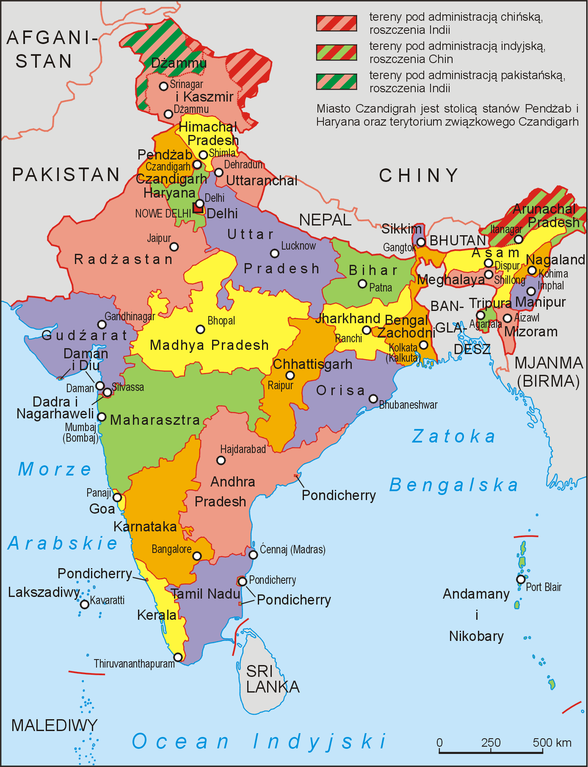
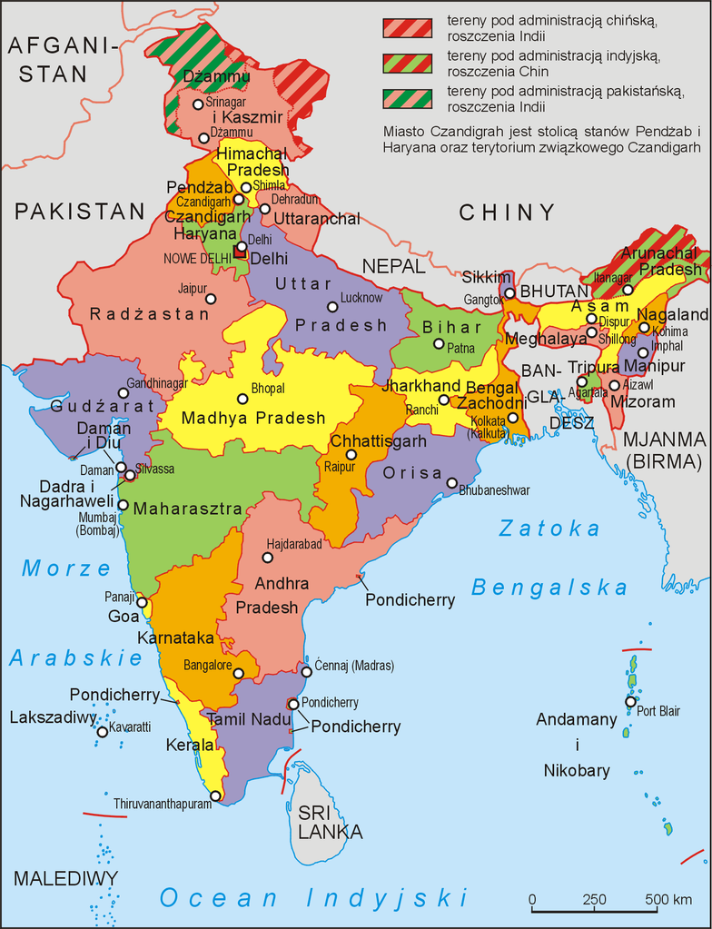
Polski: Podział administracyjny Indii w 2000 roku. Podano polskie nazwy jednostek administracyjnych i ich stolic w formie zalecanej przez Komisję Standaryzacji Nazw Geograficznych (http://ksng.gugik.gov.pl/pliki/wpngs_azja.pdf), w przypadku braku takich nazw, podano nazwy angielskie English: current districts of India |
||||||||
| Source | Praca własna na podstawie map administracyjnych Indii i opisów zmiany podziału administracyjnego zamieszczonego na stronie http://www.statoids.com/uin.html | ||||||||
| Author | Aotearoa | ||||||||
| Permission (Reusing this file) |
|


|
This locator map image could be re-created using vector graphics as an SVG file. This has several advantages; see Commons:Media for cleanup for more information. If an SVG form of this image is available, please upload it and afterwards replace this template with
{{vector version available|new image name}}.
It is recommended to name the SVG file “Indie 2006.svg”—then the template Vector version available (or Vva) does not need the new image name parameter. |
File history
Click on a date/time to view the file as it appeared at that time.
| Date/Time | Thumbnail | Dimensions | User | Comment | |
|---|---|---|---|---|---|
| current | 08:30, 18 June 2012 | | 1,389 × 1,813 (400 KB) | Aotearoa (talk | contribs) | Aktualne polskie nazwy zalecane przez KSNG |
| 06:09, 2 August 2006 |  | 1,041 × 1,360 (180 KB) | Roman 92 (talk | contribs) | {{Information |Description='''pl''': aktualny podział administracyjny Indii.<br/>'''en''': current districts of India |Source= |Date= |Author=Aotearoa |Permission={{GFDL-user-w|w:pl|Polish Wikipedia|Aotearoa}} |other_versions= }}[[ |
You cannot overwrite this file.
File usage on Commons
The following page uses this file:
File usage on other wikis
The following other wikis use this file:
- Usage on es.wikipedia.org
- Usage on pl.wikipedia.org
- Usage on pl.wikinews.org
- Usage on pl.wikivoyage.org
- Usage on sw.wikipedia.org
- Uhindi
- Kashmir
- Gujarat
- Kigezo:Mbegu-jio-Uhindi
- Majimbo ya Uhindi
- Andhra Pradesh
- Arunachal Pradesh
- Assam
- Bihar
- Chhattisgarh
- Goa
- Haryana
- Himachal Pradesh
- Jharkhand
- Karnataka
- Kerala
- Madhya Pradesh
- Maharashtra
- Manipur
- Meghalaya
- Mizoram
- Nagaland
- Orissa
- Rajasthan
- Sikkim
- Tamil Nadu
- Tripura
- Uttar Pradesh
- Uttarakhand
- West Bengal
- Bhubaneswar
- Agartala
- Aizawl
- Bangalore
- Bhopal
- Chennai
- Daman, Uhindi
- Dehradun
View more global usage of this file.