File:India WDL388.png
Jump to navigation
Jump to search
Size of this preview: 491 × 600 pixels. Other resolutions: 196 × 240 pixels | 393 × 480 pixels | 629 × 768 pixels | 1,024 × 1,251 pixels.
Original file (1,024 × 1,251 pixels, file size: 2.81 MB, MIME type: image/png)
Captions
Captions
Add a one-line explanation of what this file represents
Summary
[edit]
| Русский: Индия
Français : Inde English: India 中文:印度 Português: Índia العربية: الهند Español: India |
|
|---|---|
| Author |
Русский: "Dodd, Mead and Company"
Français : Dodd, Mead & Company
English: Dodd, Mead and Company
中文:J·N· 马修斯公司
Português: Dodd, Mead and Company
العربية: دود، ميد وشركاؤهم
Español: Dodd, Mead and Company |
| Title |
Русский: Индия
Français : Inde
English: India
中文:印度
Português: Índia
العربية: الهند
Español: India |
| Description |
Русский: На этой карте начала XX века изображены территории Британской империи в Индии: сложная политическая структура, состоящая из провинций под непосредственным управлением Британии и местных, или княжеских государств, которые управлялись косвенно через индийских правителей, подчиненных британскому сюзеренитету. Также на карте показаны французские и португальские анклавы, независимые государства Непал и Бутан и остров Цейлон (ныне Шри-Ланка), находившийся под владычеством Великобритании, но не являвшийся частью Индийской империи. Индия обрела независимость в 1947 году, но была разделена на два государства Индию и Пакистан. Последнее в свою очередь разбилось в 1971 году на Пакистан и Бангладеш. Фирма "Dodd, Mead, and Company", выпустившая карту, была основана в Нью-Йорке в 1939 году Моисеем Вудраффом Доддом и Джоном С. Тейлором, и изначально занималась публикацией книг религиозного содержания. В 1870 году фирма перешла к племяннику Додда Эдварду С. Миду и стала называться "Dodd and Mead", а позднее "Dodd, Mead, and Company". Одним из наиболее известных изданий фирмы стала 20-томная "Новая международная энциклопедия" (1903-04 гг.), в которую была включена и настоящая карта.
Français : Cette carte du début de 20ème siècle montre l'Empire britannique en Inde, une structure politique complexe qui est composée de provinces directement régies par la Grande-Bretagne et d'États autochtones - ou princiers - qui ont été administrés indirectement par l'intermédiaire de souverains indiens soumis à la suzeraineté britannique. Figurent aussi sur la carte les enclaves françaises et portugaises, les États indépendants du Népal et du Bhoutan, et l'île de Ceylan (aujourd'hui le Sri Lanka), qui était sous administration britannique, mais ne faisait pas partie de l'Empire des Indes. L'Inde devient indépendante en 1947, mais fut divisée entre les États de l'Inde et du Pakistan. Ce dernier se divisa à son tour en 1971, en Pakistan et Bangladesh. La société éditrice de la carte, Dodd, Mead and Company, a été fondée à New York en 1839 par Moïse Woodruff Dodd et John S. Taylor, et était à l'origine une société éditrice de livres religieux. En 1870, lorsque le neveu de Dodd Edward S. Mead reprit l'entreprise, celle-ci devint Dodd Mead et, plus tard, Dodd, Mead, et compagnie. L'une de ses publications les plus connues est la Nouvelle Encyclopédie Internationale en 20 tomes (1903-04), dans laquelle figure également cette carte.
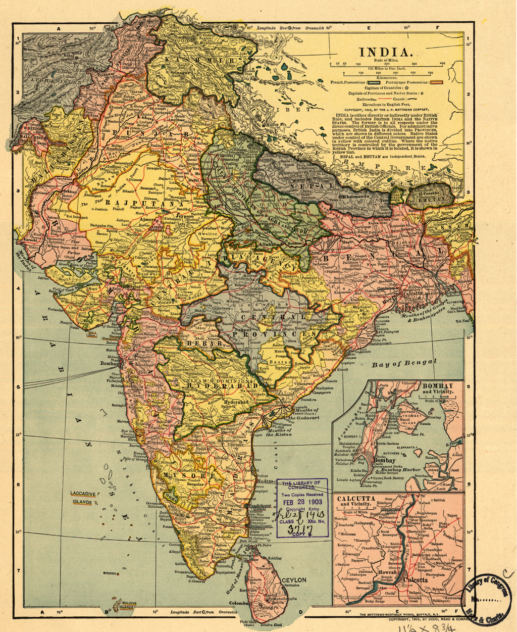
English: This early-20th century map shows the British Empire in India, a complex political structure that was made up of provinces directly ruled by Britain and the Native--or Princely--States, which were ruled indirectly through Indian sovereigns subject to British suzerainty. Also shown on the map are the French and Portuguese enclaves, the independent states of Nepal and Bhutan, and the island of Ceylon (present-day Sri Lanka), which was under British rule but not part of the Indian Empire. India became independent in 1947, but was partitioned into the states of India and Pakistan. The latter in turn split, in 1971, into Pakistan and Bangladesh. The publisher of the map, Dodd, Mead, and Company, was founded in New York in 1839 by Moses Woodruff Dodd and John S. Taylor, and was originally a publisher of religious books. In 1870, when Dodd's nephew Edward S. Mead took over the firm, it became Dodd and Mead, and later Dodd, Mead, and Company. One of its best known publications was the 20-volume New International Encyclopedia (1903-04), in which this map also appeared.
中文:这幅 20 世纪早期的地图描述了大英帝国统治下的印度,即一个由英国直接统治的省份与英国宗主权下的印度君主间接统治的本土或王侯州省组成的复杂政治结构。 地图上还显示了法国与葡萄牙的飞地,尼泊尔和不丹独立国,以及锡兰岛(今斯里兰卡),属于英国统治但不属于印度帝国的一部分。 1947 年印度独立,但分裂成两个国家,即印度与巴基斯坦。 巴基斯坦 1971 年再次分裂成巴基斯坦和孟加拉国。 本地图的出版商多德·米德公司 1839 年成立于纽约市,由摩西·伍德拉夫·多德和约翰·S·泰勒创建, 起初是一家宗教书籍出版社。 1870 年,多德的侄子爱德华·S· 米德接管公司时,公司更名为多德和米德,即后来的多德·米德公司。 公司最著名的出版物之一便是 20 卷的 《新国际百科全书》 (1903-04 年),本地图便是出自于此。
Português: Este mapa do início do século XX mostra o Império Britânico na Índia, uma estrutura política complexa composta por províncias, diretamente governadas pelo Reino Unido, e por Estados Nativos - ou Principescos- que eram governados indiretamente através de soberanos da Índia os quais eram sujeitos à suserania britânica. No mapa também aparecem os enclaves franceses e portugueses, os estados independentes do Nepal e Butão, e a Ilha de Ceilão (atual Sri Lanka), que estava sob domínio britânico, mas que não faziam parte do Império da Índia. A Índia tornou-se independente em 1947, mas foi dividida nos estados da Índia e do Paquistão. Este último, por sua vez, dividido, em 1971 em dois: Paquistão e Bangladesh. A editora do mapa, Dodd, Mead, and Company, foi fundada em Nova Iorque em 1839 por Moses Woodruff Dodd e John S. Taylor e foi, originalmente, uma editora de livros religiosos. Em 1870, quando o sobrinho de Dodd, Edward S. Mead assumiu a empresa, esta tornou-se Dodd and Mead e, mais tarde, Dodd, Mead, and Company. Uma de suas publicações mais conhecida foi a Nova Enciclopédia Internacional, com 20 volumes (1903-04), na qual este mapa também apareceu.
العربية: تبين هذه الخريطة التي التقطت في أوائل القرن العشرين الإمبراطورية البريطانية في الهند، التي كانت عبارة عن تركيبة سياسية معقدة تتألف من مقاطعات تخضع مباشرة لحكم بريطانيا ودول أهلية -- أميرية -- التي كانت تـحكم بشكل غير مباشر عن طريق ملوك هنود يخضعون للسيادة البريطانية. كما تبين الخريطة الجيوب الفرنسية والبرتغالية ودولتي نيبال وبوتان المستقلتين وجزيرة سيلان (سريلانكا اليوم) التي كانت تخصع للحكم البريطاني ولكنها لم تكن جزءا من الإمبراطورية الهندية. حصلت الهند على استقلالها في عام 1947، ولكنها قُسمت إلى دولتي الهند وباكستان. وانقسمت الأخيرة بدورها إلى دولتي باكستان وبنغلادش. أسس موسى ودْروف وجون س. تيلور شركة دود وميد وشركائهم الناشرة للخريطة في نيويورك عام 1839، وكانت في الأصل شركة ناشرة للكتب الدينية. وعندما تولى أمر الشركة ابن شقيق دود، إدوارد س. ميد، عام 1870، أصبح اسمها شركة دود وميد، ثم سُميت في وقت لاحق شركة دود وميد وشركائهم. ومن أشهر منشوراتها دائرة المعارف العالمية الجديدة التي تتألف من عشرين مجلدًا التي نُشرت في (1903- 1904)، والتي تظهر فيها هذه الخريطة.
Español: Este mapa de principios del siglo XX muestra el Imperio Británico en la India, una compleja estructura política formada por provincias directamente gobernadas por Gran Bretaña y por los Estados Nativos -- o de los Príncipes, que estaban gobernados de manera indirecta a través de los soberanos indios sujetos a la soberanía británica. También se muestran en el mapa los enclaves franceses y portugueses, los estados independientes de Nepal y Bután, y la isla de Ceilán (actualmente Sri Lanka), que estaba bajo el dominio británico pero que no era parte del Imperio en las Indias. India obtuvo la independencia en 1947, pero fue dividida en los estados de India y Pakistán. Este último se dividió a su vez en 1971, en Pakistán y Bangladesh. La editorial responsable de la publicación del mapa, Dodd, Mead, and Company, fue fundada en Nueva York en 1839 por Moses Woodruff Dodd y John S. Taylor, y fue, al principio, una editorial de libros religiosos. En 1870, cuando el sobrino de Dodd, Edward S. Mead, se hizo cargo de la firma, se convirtió en Dodd and Mead, y más tarde en Dodd, Mead, and Company. Una de sus publicaciones más famosas fue la New International Encyclopedia (Nueva Enciclopedia Internacional) (1903-04), en 20 volúmenes, en la que también apareció este mapa. |
| Date | 1903 |
| Medium |
Русский: Карты
Français : Cartes
English: Maps
中文:地图
Português: Mapas
العربية: خرائط
Español: Mapas |
| Dimensions |
English: 1 map : color ; 31 x 23 centimeters |
| Collection |
Русский: Библиотека Конгресса
Français : Bibliothèque du Congrès
English: Library of Congress
中文:国会图书馆
Português: Biblioteca do Congresso
العربية: مكتبة الكونغرس
Español: Biblioteca del Congreso |
| Place of creation |
Русский: Бангладеш
Français : Bangladesh
English: Bangladesh
中文:孟加拉国
Português: Bangladesh
العربية: بنغلاديش
Español: Bangladesh |
| References | http://hdl.loc.gov/loc.wdl/dlc.388 |
| Source/Photographer |
|
Licensing
[edit]
|
This is a faithful photographic reproduction of a two-dimensional, public domain work of art. The work of art itself is in the public domain for the following reason:
The official position taken by the Wikimedia Foundation is that "faithful reproductions of two-dimensional public domain works of art are public domain".
This photographic reproduction is therefore also considered to be in the public domain in the United States. In other jurisdictions, re-use of this content may be restricted; see Reuse of PD-Art photographs for details. | ||||
File history
Click on a date/time to view the file as it appeared at that time.
| Date/Time | Thumbnail | Dimensions | User | Comment | |
|---|---|---|---|---|---|
| current | 15:24, 11 March 2014 | | 1,024 × 1,251 (2.81 MB) | Fæ (talk | contribs) | =={{int:filedesc}}== {{Artwork |artist = |author ={{ru|1="Dodd, Mead and Company"}} {{fr|1=Dodd, Mead & Company}} {{en|1=Dodd, Mead and Company}} {{zh|1=J·N· 马修斯公司}} {{pt|1=Dodd, Mead and Company}} {{ar|1=دود، ميد وش... |
You cannot overwrite this file.
File usage on Commons
The following page uses this file:
File usage on other wikis
The following other wikis use this file:
- Usage on es.wikipedia.org