File:Illinois Basin Structure Map.jpg
Jump to navigation
Jump to search

Size of this preview: 800 × 548 pixels. Other resolutions: 320 × 219 pixels | 640 × 439 pixels | 1,068 × 732 pixels.
Original file (1,068 × 732 pixels, file size: 147 KB, MIME type: image/jpeg)
Captions
Captions
Illinois Basin Structure Map
Summary
[edit]
| Description |
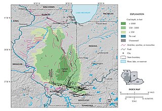
English: Illinois Basin Structure Map |
| Date | |
| Source | Geologic Overview, Chapter C of Resource Assessment of the Springfield, Herrin, Danville, and Baker Coals in the Illinois Basin, U.S. Geological Survey Professional Paper 1625–D, https://pubs.usgs.gov/pp/p1625d/Chapter_C.pdf |
| Author | J.R. Hatch and R.H. Affolter |
Licensing
[edit]
This image is in the public domain in the United States because it only contains materials that originally came from the United States Geological Survey, an agency of the United States Department of the Interior. For more information, see the official USGS copyright policy.
|
File history
Click on a date/time to view the file as it appeared at that time.
| Date/Time | Thumbnail | Dimensions | User | Comment | |
|---|---|---|---|---|---|
| current | 16:18, 9 November 2020 | | 1,068 × 732 (147 KB) | Pi3.124 (talk | contribs) | Uploaded a work by J.R. Hatch and R.H. Affolter from Geologic Overview, Chapter C of Resource Assessment of the Springfield, Herrin, Danville, and Baker Coals in the Illinois Basin, U.S. Geological Survey Professional Paper 1625–D, https://pubs.usgs.gov/pp/p1625d/Chapter_C.pdf with UploadWizard |
You cannot overwrite this file.
File usage on Commons
There are no pages that use this file.
File usage on other wikis
The following other wikis use this file:
- Usage on en.wikipedia.org