File:Iceland municipalities terrain map.gif
Jump to navigation
Jump to search
No higher resolution available.
Iceland_municipalities_terrain_map.gif (480 × 470 pixels, file size: 34 KB, MIME type: image/gif)
Captions
Captions
Add a one-line explanation of what this file represents
Summary
[edit]

|
This file was moved to Wikimedia Commons from en.wikipedia using a bot script. All source information is still present. It requires review. Additionally, there may be errors in any or all of the information fields; information on this file should not be considered reliable and the file should not be used until it has been reviewed and any needed corrections have been made. Once the review has been completed, this template should be removed. For details about this file, see below. Check now! |
| Description |
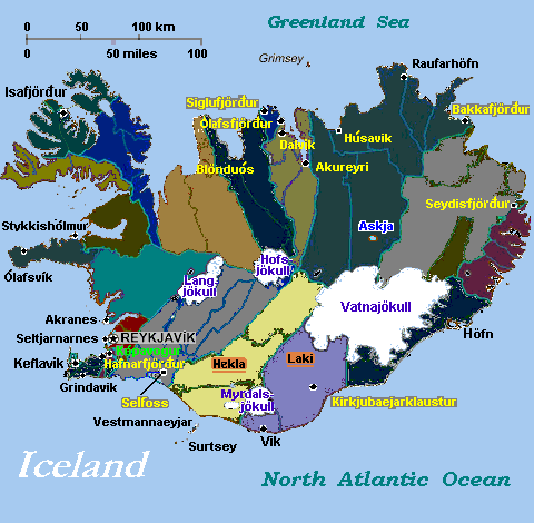
English: Map of Iceland with sections colored and some cities, glaciers, and volcanoes labeled, annotated from CIA World Factbook.
Image is trimmed/expanded 181% (16% larger detail) in GIF format, like source [GIF Image can be edited without loss of detail.] References
|
| Source | |
| Author |
Licensing
[edit]
This image is in the public domain because it contains materials that originally came from the United States Central Intelligence Agency's World Factbook.
|
 |
Original upload log
[edit]
The original description page was here. All following user names refer to en.wikipedia.
- 2007-01-24 14:39 Wikid77 480×470× (34478 bytes) narrowed 25px to auto-display 5% larger (25/505 pixels = 5%): narrow width displays larger lettering (re-reload).
- 2007-01-24 14:35 Wikid77 1000×470× (65682 bytes) narrowed 25px to auto-display 5% larger (25/505 pixels = 5%): narrow width displays larger lettering.
- 2007-01-24 07:44 Wikid77 505×470× (34804 bytes) re-spelled fjord names; added 3 (Kopavogur, Olafsvik, and Stykkisholmur); clarified lines to cut 10% from image file-size.
- 2007-01-23 15:42 Wikid77 505×470× (38618 bytes) Map of [[Iceland]] with sections colored and some cities, glaciers, and volcanoes labeled, annotated from [http://www.lib.utexas.edu/maps/cia03/iceland_sm03.gif CIA World Factbook]. Image is trimmed/expanded 181% (16% larger detail) in GIF format, like s
File history
Click on a date/time to view the file as it appeared at that time.
| Date/Time | Thumbnail | Dimensions | User | Comment | |
|---|---|---|---|---|---|
| current | 02:30, 19 February 2011 | | 480 × 470 (34 KB) | File Upload Bot (Magnus Manske) (talk | contribs) | {{BotMoveToCommons|en.wikipedia|year={{subst:CURRENTYEAR}}|month={{subst:CURRENTMONTHNAME}}|day={{subst:CURRENTDAY}}}} {{Information |Description={{en|Map of en:Iceland with sections colored and some cities, glaciers, and volcanoes labeled, annotat |
You cannot overwrite this file.
File usage on Commons
There are no pages that use this file.